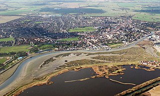
Maldon is a town and civil parish on the Blackwater estuary in Essex, England. It is the seat of the Maldon District and starting point of the Chelmer and Blackwater Navigation. It is known for Maldon Sea Salt which is produced in the area.

South Mimms is a village and civil parish in the Hertsmere district of Hertfordshire in the East of England. It is a small settlement located near to the junction of the M25 motorway with the A1(M) motorway.

Staindrop is a village and civil parish in County Durham, England. It is situated approximately 6 miles (9.7 km) north east of Barnard Castle, on the A688 road. According to the 2011 UK Census the population was 1,310, this includes the hamlets of Cleatlam and Killerby.

Bovey Tracey is a small town and civil parish in Devon, England, on the edge of Dartmoor, its proximity to which gives rise to the "slogan" used on the town's boundary signs, "The Gateway to the Moor". It is often known locally as "Bovey". It is about 10 miles south-west of Exeter and lies on the A382 road, about halfway between Newton Abbot and Moretonhampstead. The village is at the centre of the electoral ward of Bovey. At the 2011 census the population of this ward was 7,721.

St Giles' Parish Church is the parish church of Wrexham, Wales. The church is recognised as one of the finest examples of ecclesiastical architecture in Wales and is a Grade I listed building, described by Sir Simon Jenkins as 'the glory of the Marches' and by W. D. Caröe as a “glorious masterpiece.”

St Athan is a village and community in the Vale of Glamorgan in South Wales. The village and its parish church are dedicated to Saint Tathan. The church dates to the 13th–14th century, though an earlier church was dated to the Norman period. The village and the adjacent dormitory village of Eglwys Brewis are known primarily for the MOD St Athan RAF base. There are two pubs in the village, as well as a football team at St Athan Football Club and the St Athan Golf Club. The community includes West Aberthaw.

Eydon is a village and civil parish in West Northamptonshire, about 8 miles (13 km) north-east of Banbury. The village is between 510 and 540 feet (160 m) above sea level on the east side of a hill, which rises to 580 feet (180 m) and is the highest point in the parish. The parish is bounded to the west by the River Cherwell, to the south by a stream that is one of its tributaries, and to the east and north by field boundaries.

Caddington is a village and civil parish in the Central Bedfordshire district of Bedfordshire, England. It is between the Luton/Dunstable urban area, and Hertfordshire.

Elmstead Market is a village in the civil parish of Elmstead, in the Tendring district of Essex, England. It lies 3 km north-east of Wivenhoe and 6 km east of Colchester. It is on the A133 road which runs to Clacton-on-Sea to the south-east and Colchester to the west. In 2018 it had an estimated population of 1,684.

St Mary's Church is an Anglican church at the end of a lane to the south of the village of Nether Alderley, Cheshire, England. It dates from the 14th century, with later additions and a major restoration in the late-19th century. The church is recorded in the National Heritage List for England as a designated Grade I listed building.

St Lawrence's Church, Over Peover is in the civil parish of Peover Superior. Close to Peover Hall and farm. It lies some 3 miles (5 km) south of the town of Knutsford. The church is recorded in the National Heritage List for England as a designated Grade I listed building. The church is an active Anglican parish church in the diocese of Chester, the archdeaconry of Macclesfield and the deanery of Knutsford. Its benefice is combined with that of St Oswald, Lower or Nether Peover. It is noted for its old chapels and for the monuments to the Mainwaring family.

Appleton is a village in the civil parish of Appleton-with-Eaton, about 4 miles (6.4 km) northwest of Abingdon. Appleton was part of Berkshire until the 1974 boundary changes transferred it to Oxfordshire. The 2011 Census recorded Appleton-with-Eaton's parish population as 915.

Friskney is a village and civil parish within the East Lindsey district of Lincolnshire, England.
Lewknor is a village and civil parish about 5 miles (8 km) south of Thame in Oxfordshire.The civil parish includes the villages of Postcombe and South Weston. The 2011 Census recorded the parish's population as 663.

Elmsted is a village and civil parish in the Folkestone and Hythe District of Kent, England. It is located west of Stone Street, the Roman road which today takes traffic between Canterbury and Lympne. Within the parish are the settlements of Bodsham, North Leigh and Evington. There are six elected members of the Parish Council.

Sutton is a village and civil parish in the District of Rochford in Essex, England. It is located between the River Roach and the adjoining Borough of Southend-on-Sea, and includes the hamlet of Shopland. It has a population of 127, increasing at the 2011 Census to 135, the smallest in the District, although at the time of the Domesday Book it had a flourishing village with its own market and fair.

Rickling is a village and former civil parish, now in the parish of Quendon and Rickling, in the Uttlesford district of Essex, England. The village is situated approximately 6 miles (10 km) north from the town of Bishop's Stortford. Saffron Walden, at 5 miles (8 km), and the larger village of Newport, at 2 miles (3 km), lie to the north-east. In 1931 the parish had a population of 378.

Monk Street is an historic street in the town of Monmouth, Monmouthshire, Wales. A portion of it was in existence by the 14th century, and appears on the 1610 map of the town by cartographer John Speed. It runs in a north-south direction, extending northward from its intersection with Whitecross Street. The name of the street relates to the nearby Priory, as well as the gate which was originally on this road and provided part of the town's defences, Monk's Gate. Monk Street is lined with numerous listed buildings.

St Mary the Virgin Church is located in Latton, Harlow, Essex, England. It is an Anglican church and is liberal catholic in tradition. The church building is Grade I listed.

The Church of All Saints is the Anglican parish church in the village of Campton, Shefford, Bedfordshire, England. Its official title is Campton and Chicksands Parish and encompasses the villages of Campton and Chicksands and the nearby military base, despite the base having its own church dedicated to Saint Gilbert of Sempringham. The military church is a non-denominational church, so it is not a part of the Anglican parish.

