
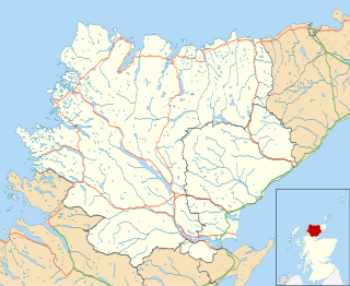
Sutherland is a historic county, registration county and lieutenancy area in the Highlands of Scotland. Its county town is Dornoch. Sutherland borders Caithness and Moray Firth to the east, Ross-shire and Cromartyshire to the south and the Atlantic to the north and west. Like its southern neighbour Ross-shire, Sutherland has some of the most dramatic scenery in the whole of Europe, especially on its western fringe where the mountains meet the sea. These include high sea cliffs, and very old mountains composed of Precambrian and Cambrian rocks.

Knockan is a township of six crofts in the community of Ardtun, in the south of the Isle of Mull off the west coast of Scotland.

Suilven is a mountain in Scotland. Lying in a remote area in the west of Sutherland, it rises from a wilderness landscape of moorland, bogs, and lochans known as Inverpolly National Nature Reserve. Suilven forms a steep-sided ridge some two kilometres in length. The highest point, Caisteal Liath, lies at the northwest end of this ridge. There are two other summits: Meall Meadhonach at the central point of the ridge is 723 metres (2,372 ft) high, whilst Meall Beag lies at the southeastern end.
Lochinver is a village that is located at the head of the sea loch Loch Inver, on the coast in the Assynt district of Sutherland, Highland, Scotland. A few miles northeast is Loch Assynt which is the source of the River Inver which flows into Loch Inver at the village. There are 200 or so lochans in the area which makes the place very popular with anglers. Lochinver is dominated by the "sugar loaf" shape of Caisteal Liath, the summit peak of nearby Suilven.
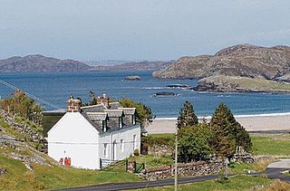
Clashnessie is a small crofting community on the North-West coast of Scotland; specifically in the Assynt area of Sutherland.

Cawdor is a village and parish in the Highland council area, Scotland. The village is 5 miles south-southwest of Nairn and 12 miles east of Inverness. The village is in the Historic County of Nairnshire.
Achmelvich is a settlement situated in the Highland region of Scotland. The name comes from the Gaelic "Achadh" - a plain or meadow and "mealbhaich" - sandy dunes.

Assynt is a sparsely populated area in the south-west of Sutherland, lying north of Ullapool on the west coast of Scotland. Assynt is known for its landscape and its remarkable mountains, which have led to the area, along with neighbouring Coigach, being designated as the Assynt-Coigach National Scenic Area, one of 40 such areas in Scotland.

Insch is a village in the Garioch, Aberdeenshire, Scotland. It is located approximately 28 miles (45 km) from the city of Aberdeen. Insch, pronounced Inch, is the smallest village in Scotland.
Coigach is a peninsula north of Ullapool, in Wester Ross in the Northwest Highlands of Scotland. The area consists of a traditional crofting and fishing community of a couple of hundred houses located between mountain and shore on a peninsula looking over the Summer Isles and the sea. The main settlement is Achiltibuie. Like its northerly neighbour, Assynt in Sutherland, Coigach has mountains which rise sharply from quiet, lochan-studded moorland, and a highly indented rocky coast with many islands, bays and headlands. The highest summit is Ben Mor Coigach at 743 metres; the distinctive profile of Stac Pollaidh is the other main peak within Coigach. The scenic qualities of Coigach, along with neighbouring Assynt, have led to the area being designated as the Assynt-Coigach National Scenic Area, one of 40 such areas in Scotland.

The River Oykel is a major river in northern Scotland that is famous for its salmon fishing. It rises on Ben More Assynt, a few miles from Ullapool on the west coast of Scotland, and drains into the North Sea via the Kyle of Sutherland. Traditionally it has marked the boundary between Ross to the south and Sutherland to the north.

Ben More Assynt is a mountain in Assynt in the far north-west of Scotland, 30 kilometres north-northeast of Ullapool. The name translates as "big mountain of Assynt", and with a height of 998 metres it is the highest point in Sutherland.

Glencaple is a small settlement in the Dumfries and Galloway area of Scotland. Situated on the banks of the River Nith, it once served as a port for nearby Dumfries. Glencaple is a Gaelic name meaning 'horse valley' from the words gleann 'narrow valley' and capall 'horse, mare'.

Lumphanan is a village in Aberdeenshire, Scotland located 25 miles (40 km) from Aberdeen and 10 miles (16 km) from Banchory.

Loch Assynt is a freshwater loch in Sutherland, Scotland, 8 kilometres (5.0 mi) east-north east of Lochinver.
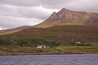
Inchnadamph is a hamlet in Assynt, Sutherland, Scotland. The name is an anglicisation of the Gaelic name Innis nan Damh meaning 'meadow of the stags'. Assynt is a remote area with a low population density. Inchnadamph contains a few houses, a lodge, a hotel and a historic old church, graveyard and mausoleum.

Knockan Crag lies within the North West Highlands Geopark in the Assynt region of Scotland 21 kilometres (13 mi) north of Ullapool. During the nineteenth century Knockan Crag became the subject of much debate when geologists noted that the Moine schists at the top of the crag appeared to be older than the Cambrian and Ordovician rocks such as Durness limestone lower down. Disagreements over the processes that could have caused this to occur were referred to at the time as the 'Highlands Controversy'. The argument was primarily between Roderick Murchison and Archibald Geikie on the one hand and James Nicol and Charles Lapworth on the other. Murchison and Geikie believed the sequence was wrong and that the Moine schists must be the younger rocks. The controversy was finally resolved by the work of Ben Peach and John Horne whose 1907 paper on the subject remains a classic text. Peach and Horne demonstrated that the situation resulted from the action of a thrust fault - this being the first to be discovered anywhere in the world. The older rocks had been moved some 70 kilometres to the west over the top of the younger rocks due to tectonic action.

Glendaruel is a glen in the Cowal peninsula in Argyll and Bute, Scotland.
Stoer is a crofting township in the parish of Assynt, Sutherland, in the Highlands of Scotland and in the council area of Highland. It is located about five miles north of the village of Lochinver.

Staffin is a district with the Gaelic name An Taobh Sear, which translates as "the East Side", on the northeast coast of the Trotternish peninsula of the island of Skye. It is located on the A855 road about 17 miles north of Portree and is overlooked by the Trotternish Ridge with the famous rock formations of The Storr and the Quiraing. The district comprises 23 townships made up of, from south to north, Rigg, Tote, Lealt, Lonfearn, Grealin, Breackry, Cul-nan-cnoc, Bhaltos, Raiseburgh, Ellishadder, Garafad, Clachan, Garros, Marrishader, Maligar, Stenscholl, Brogaig, Sartle, Glasphein, Digg, Dunan, Flodigarry and Greap. The Kilmartin River runs northwards through the village. From where it reaches the sea a rocky shore leads east to a slipway at An Corran. Here a local resident found a slab bearing a dinosaur track, probably made by a small ornithopod. Experts subsequently found more dinosaur prints of up to 50 cm, the largest found in Scotland, made by a creature similar to Megalosaurus. At about 160 million years old they are the youngest dinosaur remains to be found in Scotland.

