Related Research Articles
Powersite is an unincorporated community in Taney County, Missouri, United States. It is located across Lake Taneycomo from Forsyth on the southeast end of Powersite Dam. The community is part of the Branson, Missouri Micropolitan Statistical Area.
Carr Lane is an unincorporated community in Stone County, Missouri, United States. Located at the intersection of State Routes 39 and 86, it lies approximately one mile north of the Arkansas state line and one mile east of the Stone - Barry county line. The community is part of the Branson, Missouri Micropolitan Statistical Area.
Cape Fair is an unincorporated community in Stone County, Missouri, United States. It is located on Route 76 and the southern terminus of Route 173. Cape Fair is on the west side of the James River arm of Table Rock Lake. The community is part of the Branson, Missouri Micropolitan Statistical Area. The ZIP Code for Cape Fair is 65624.
Osa is an unincorporated community in the northeast corner of Barry County, in the U.S. state of Missouri. The community is on Missouri Route JJ 1.5 miles north of Revisville. Crane in adjacent Stone County is three miles to the east.
Garland is an unincorporated community in Henry County, in the U.S. state of Missouri. The community is on an abandoned railroad line in an old coal mining area, approximately six miles northwest of Clinton, just east of Missouri Route O.
Joanna is an extinct town in Ralls County, in the U.S. state of Missouri. The GNIS classifies it as a populated place.
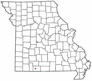
Abesville is an unincorporated community in east central Stone County, in the U.S. state of Missouri. Abesville is located on Missouri Route 176, approximately two miles west of U.S. Route 160 and the Stone – Christian county line.
Browns Spring is an unincorporated community in Stone County, in the U.S. state of Missouri. It is about 7 miles south of Clever and is about 3 miles west of Union City.
Carico is an unincorporated community in Stone County, in the U.S. state of Missouri. Carico is located at the junction of Railey Creek and Carico Hollow, approximately 3.5 miles east-southeast of Galena and 6.5 miles northwest of Reeds Spring along the Missouri Pacific Railroad.
Dry Creek is a stream in the U.S. state of Missouri. It is a tributary of Flat Creek.
Notch is an unincorporated community in Stone County, in the U.S. state of Missouri. Notch is located just north of Silver Dollar City on Missouri Route 76.
Oto is an unincorporated community in Stone County, in the U.S. state of Missouri. The community is located on Crane Creek, approximately four miles north of Galena. Missouri Route AA passes through the community along Oto Ridge to the north of the Crane Creek crossing.
Pine Run is a stream in Stone County, Missouri. It is a tributary of the James River which it joins on the northeast side of Galena. The headwaters are located west of Elsey. Missouri routes 13, 265 and the Missouri Pacific Railroad line follow the Pine Run valley between Elsey and Galena.
Radical is an extinct town in Stone County, in the U.S. state of Missouri. The GNIS classifies it as a populated place.
Wheeler Branch is a stream in Stone County in the Ozarks of southwest Missouri. It is a tributary of the James River.
Day is an unincorporated community in Taney County, in the Ozarks of southern Missouri. Day is located in the northwest part of the county, just south of the Taney-Christian county line on Missouri Route 176 and approximately one mile west of U.S. Route 65.
Dickens is an unincorporated community in north central Taney County, in the U.S. state of Missouri. The community is located on Missouri Route 76, approximately one mile southwest of Taneyville and 4.5 miles northeast of Forsyth.
Flag is an extinct community in Taney County, in the U.S. state of Missouri. It was on the west side of the county, near the Stone County line, a bit north of the present day location of the Table Rock Dam.
Mildred is an unincorporated community in Taney County, in the Ozarks of southern Missouri. Mildred is located on Missouri Route 76, south of Forsyth and east of Kirbyville.
Swan is an unincorporated community in north central Taney County, in the U.S. state of Missouri. Swan is located on Missouri Route AA, along Blue Creek and approximately 3.5 miles northwest of Taneyville.
References
- ↑ U.S. Geological Survey Geographic Names Information System: Elsey, Missouri
- ↑ "Post Offices". Jim Forte Postal History. Retrieved 27 December 2016.
- ↑ "Stone County Place Names, 1928–1945". The State Historical Society of Missouri. Archived from the original on June 24, 2016. Retrieved December 27, 2016.
Municipalities and communities of Stone County, Missouri, United States | ||
|---|---|---|
| Cities |  | |
| Villages | ||
| CDP | ||
| Unincorporated communities | ||
| Ghost town | ||
| Footnotes | ‡This populated place also has portions in an adjacent county or counties | |
36°51′15″N93°32′27″W / 36.85417°N 93.54083°W
| | This Stone County, Missouri state location article is a stub. You can help Wikipedia by expanding it. |