Elsternwick railway station

Last updated

Elsternwick
PTV commuter rail station
Elsternwickstation2021.jpg
North-west bound view from Platform 2,
December 2021
General information
LocationGlen Huntly Road,
Elsternwick, Victoria 3185
City of Glen Eira
Australia
Coordinates 37°53′05″S145°00′03″E / 37.8848°S 145.0009°E / -37.8848; 145.0009
Owned by VicTrack
Operated by Metro Trains
Line(s) Sandringham
Distance10.95 kilometres from
Southern Cross
Platforms1 island
Tracks2
Connections
  • Victoria bus logo.svg Bus
  • Melbourne tram logo.svg Tram
  • Melbourne skybus logo.svg SkyBus
Construction
Structure typeBelow ground
Parking84
Bicycle facilitiesYes
AccessibleYes—step free access
Other information
StatusOperational, premium station
Station codeELS
Fare zone Myki Zone 1
Website Public Transport Victoria
History
Opened19 December 1859;164 years ago (1859-12-19)
Rebuilt2 October 1960
ElectrifiedMay 1919 (1500 V DC overhead)
Passengers
2005–2006841,257 [1]
Preceding station Melbourne train logo.svg Metro Trains Following station
Ripponlea Sandringham line Gardenvale
towards Sandringham
Former services
Preceding station Disused railways Following station
Junction  Rosstown Railway   Garden Vale
towards Oakleigh
Track layout
BSicon MFADEg.svg
BSicon STR.svg
BSicon MFADEg.svg
BSicon STR.svg
BSicon STRg.svg
BSicon STRf.svg
1
BSicon PSTR(L).svg
BSicon PSTR(R).svg
BSicon PSTR(L).svg
2
BSicon PSTR(R).svg
BSicon KRWgl.svg
BSicon KRWg+r.svg
BSicon STRg.svg
BSicon STRf.svg
BSicon MFADEf.svg
BSicon STR.svg
BSicon MFADEf.svg
BSicon STR.svg

Elsternwick railway station is located on the Sandringham line in Victoria, Australia. It serves the south-eastern Melbourne suburb of Elsternwick, and it opened on 19 December 1859. [4]

Contents

History

Elsternwick station was originally part of the Melbourne & Hobson's Bay United Railway Company's network. The company and network was taken over by the Government of Victoria in 1878, to become part of Victorian Railways. As with the nearby suburb of Ripponlea, which had been named after the adjacent Rippon Lea Estate of Frederick Sargood, Elsternwick had been named after the largest property in the district, Charles Ebden's Elster. [5]

In the 1880s, Elsternwick also functioned as the western end of the cross-suburban Rosstown Railway, which was built by entrepreneur William Murray Ross, mainly to serve the sugar beet processing mill that he had established, along with an adjoining residential estate in the locality he called Rosstown, now known as Carnegie. The railway was seldom used and it was officially closed in 1916.

In 1915, an electric tramline between Elsternwick and Point Ormond opened. It closed on 22 October 1960, after which the tram route became part of an extended 246 bus route. In February 1959, a project commenced to eliminate the Glen Huntly Road level crossing, where a tramway also crossed the rail line. A temporary two-track station was provided in a side street parallel with the station, which allowed rail services to continue uninterrupted. In October 1960, the work was completed, which was when the present railway buildings were provided. [6] [7] [8]

In 1992, the station was the first in Melbourne to receive the former Public Transport Corporation's teal, sunflower and white coloured station signage, [9] which has since been replaced with Public Transport Victoria branded blue signage. On 13 November 1995, Elsternwick was upgraded to a premium station. [10]

During 2002–2003, the ground-level station car-park was closed, with a residential/retail development built on it, as part of a deal under which a developer was given the land with the condition that a multi-storey car park, including a lift, was provided for passengers. In 2004, the station underwent a refurbishment. [4]

Platforms and services

Elsternwick has one island platform with two faces. It is serviced by Metro Trains' Sandringham line services. [11]

Platform 1:

Platform 2:

CDC Melbourne operates two bus routes via Elsternwick station, under contract to Public Transport Victoria:

Kinetic Melbourne operates two routes via Elsternwick station, under contract to Public Transport Victoria:

Yarra Trams operates one route via Elsternwick Station

SkyBus also operates a service to Melbourne Airport via Elsternwick station. [17]

Related Research Articles

<span class="mw-page-title-main">City of Glen Eira</span> Local government area in Victoria, Australia

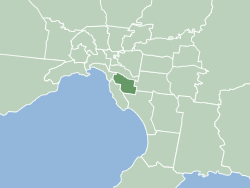
The City of Glen Eira is a local government area in Victoria, Australia. It is located in the south-eastern suburbs of Melbourne. It has an area of 39 square kilometres (15.06 sq mi) and has an estimated population of 153,858.

<span class="mw-page-title-main">Glen Iris railway station</span> Railway station in Melbourne, Australia

Glen Iris railway station is a commuter railway station in Glen Iris, a suburb of Melbourne, Victoria, Australia. The station opened on 24 March 1890 as part of the branch line from Burnley to Waverley Road station. The station consists of one island platform accessed by a pedestrian underpass. There is one principal station building located towards the Down end of the platform. The single-story building, constructed in 1975 as part of the station's rebuild, acts as a shelter and has toilet facilities. The station is only partially accessible due to steep access ramps.

<span class="mw-page-title-main">Caulfield, Victoria</span> Suburb of Melbourne, Victoria, Australia

Caulfield is a suburb in Melbourne, Victoria, Australia, 10 kilometres (6.2 mi) south-east of Melbourne's Central Business District, located within the City of Glen Eira local government area. Caulfield recorded a population of 5,748 at the 2021 census.

<span class="mw-page-title-main">Elsternwick, Victoria</span> Suburb of Melbourne, Victoria, Australia

Elsternwick is an inner suburb in Melbourne, Victoria, Australia, 9 km south-east of Melbourne's Central Business District, located within the City of Glen Eira local government area. Elsternwick recorded a population of 10,887 at the 2021 census.

<span class="mw-page-title-main">Richmond railway station, Melbourne</span> Railway station in Melbourne, Australia

Richmond railway station is a commuter railway station and the junction point for the Alamein, Belgrave, Cranbourne, Frankston, Glen Waverley, Lilydale, Pakenham and Sandringham lines, serving the south-eastern inner Melbourne suburb of Richmond, Victoria, Australia. Richmond is a premium status elevated structure station featuring ten platforms, with five island platforms. The stations opened on 8 February 1859 as Punt Road before being renamed Swan Street on 12 December of the same year, it was renamed Richmond on 1 January 1867.

<span class="mw-page-title-main">Ormond railway station</span> Railway station in Melbourne, Australia

Ormond railway station is located on the Frankston line in Victoria, Australia. It serves the south-eastern Melbourne suburb of Ormond, and opened on 19 December 1881 as North Road. It was renamed Ormond on 1 September 1897.

<span class="mw-page-title-main">Carnegie railway station</span> Railway station in Melbourne, Australia

Carnegie railway station is a commuter railway station located in the suburb of Carnegie, in the southeastern suburbs of Melbourne, Victoria, Australia. The station originally opened in 1879 as Rosstown. The station received its current name in 1909 alongside the renaming of the suburb. The station consists of a single island platform connected to the station concourse on Koornang Road via escalators, lifts and a staircase.
<span class="mw-page-title-main">Murrumbeena railway station</span> Railway station in Melbourne, Australia

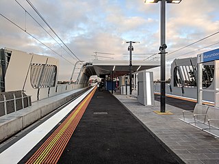
Murrumbeena railway station is located on the Pakenham and Cranbourne lines in Victoria, Australia. It serves the south-eastern Melbourne suburb of Murrumbeena, and it opened on 14 May 1879.

<span class="mw-page-title-main">Oakleigh railway station</span> Railway station in Melbourne, Australia

Oakleigh railway station is a commuter railway station in the suburb of Oakleigh in the south-east of Melbourne, Victoria, Australia. The station opened in 1877 as the up end of the Gippsland line, with the station being electrified in 1922. The station consists of two sides that are connected to each other via the adjacent roads, and both platforms are connected to each other via a pedestrian subway.

<span class="mw-page-title-main">Ripponlea railway station</span> Railway station in Melbourne, Australia

Ripponlea railway station is located on the Sandringham line in Victoria, Australia. It serves the south-eastern Melbourne suburb of Ripponlea, and opened on 1 May 1912.

<span class="mw-page-title-main">Gardenvale railway station</span> Railway station in Melbourne, Australia

Gardenvale railway station is located on the Sandringham line in Victoria, Australia. It serves the south-eastern Melbourne suburb of Brighton, and it opened on 10 December 1906.

<span class="mw-page-title-main">North Brighton railway station</span> Railway station in Melbourne, Australia

North Brighton railway station is located on the Sandringham line in Victoria, Australia. It serves the south-eastern Melbourne suburb of Brighton, and it opened on 19 December 1859 as Bay Street. It was renamed North Brighton on 1 January 1867, renamed Brighton on 1 December 1908, and renamed North Brighton on 1 January 1920.
<span class="mw-page-title-main">Middle Brighton railway station</span> Railway station in Melbourne, Australia

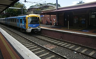
Middle Brighton railway station is located on the Sandringham line in Victoria, Australia. It serves the south-eastern Melbourne suburb of Brighton, and it opened on 21 December 1861 as Church Street. It was renamed Middle Brighton on 1 January 1867.

<span class="mw-page-title-main">Brighton Beach railway station</span> Railway station in Melbourne, Australia

Brighton Beach railway station is a commuter railway station, located on the Sandringham line in Victoria, Australia. It serves the south-eastern Melbourne suburb of Brighton, opened on 21 September 1861 as Beach, and renamed Brighton Beach on 1 January 1867. The station building is listed on the Victorian Heritage Register, noted for its unusual shape and proximity to the coastline. The Brighton Bathing Boxes are located a short walk from the station.

<span class="mw-page-title-main">Sandringham railway station</span> Railway station in Melbourne, Australia

Sandringham railway station is the terminus of the suburban electrified Sandringham line in Victoria, Australia. It serves the south-eastern Melbourne suburb of Sandringham, and it opened on 2 September 1887.

<span class="mw-page-title-main">West Richmond railway station</span> Railway station in Richmond, Melbourne, Victoria, Australia

West Richmond railway station is located on the Mernda and Hurstbridge lines in Victoria, Australia. It serves the inner eastern Melbourne suburb of Richmond, and it opened on 21 October 1901.

<span class="mw-page-title-main">North Richmond railway station</span> Railway station in Richmond, Australia

North Richmond railway station is located on the Mernda and Hurstbridge lines in Victoria, Australia. It serves the inner eastern Melbourne suburb of Richmond, and opened on 21 October 1901.

<span class="mw-page-title-main">Collingwood railway station</span> Railway station in Abbotsford, Melbourne, Victoria, Australia

Collingwood railway station is located on the Mernda and Hurstbridge lines in Victoria, Australia. It serves the north-eastern Melbourne suburb of Abbotsford, and opened on 21 October 1901 as Collingwood Town Hall. It was renamed Collingwood on 1 May 1909.
<span class="mw-page-title-main">Victoria Park railway station, Melbourne</span> Railway station in Melbourne, Australia

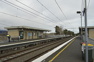
Victoria Park railway station is located on the Mernda and Hurstbridge lines in Victoria, Australia. It serves the north-eastern Melbourne suburb of Abbotsford, and it opened on 8 May 1888 as Collingwood. It was renamed Victoria Park on 1 May 1909.
<span class="mw-page-title-main">Elwood, Victoria</span> Suburb of Melbourne, Victoria, Australia

Elwood is an inner suburb in Melbourne, Victoria, Australia, 8 km south-east of Melbourne's Central Business District, located within the City of Port Phillip local government area. Elwood recorded a population of 15,153 at the 2021 census.

References

  1. 1 2 3 4 Estimated Annual Patronage by Network Segment Financial Year 2005–2006 to 2018–19 Department of Transport
  2. 1 2 3 4 5 6 7 8 9 10 11 12 Railway station and tram stop patronage in Victoria for 2008–2021 Philip Mallis
  3. Annual metropolitan train station patronage (station entries) Data Vic
  4. 1 2 "Elsternwick". vicsig.net. Retrieved 20 January 2023.
  5. Elster was German for "magpie". The creek nearby became known as the Elster Creek and, when a village grew up on the creek, the Anglo-Saxon suffix ‘wick’, meaning village, was added. Archived 1 October 2006 at the Wayback Machine
  6. "Grade Separation Scheme" Railway Gazette 19 February 1960 page 216
  7. "Grade Separation Scheme" Railway Gazette 11 November 1960 page 560
  8. SE Dornan & RG Henderson (1979). Electric Railways of Victoria. Australian Electric Traction Society. p. 50. ISBN   0-909459-06-1.
  9. MacDonald, Jacqui (13 June 1992). "PTC tackles its image problem with a $75,000 logo". The Age . p. 6.
  10. "Upgrading Eltham to a Premium Station". Newsrail . Australian Railway Historical Society. October 1997. pp. 303–315.
  11. "Sandringham Line". Public Transport Victoria.
  12. "606 Elsternwick Station - Fishermans Bend". Public Transport Victoria.
  13. "625 Elsternwick - Chadstone via Ormond & Oakleigh". Public Transport Victoria.
  14. "246 Elsternwick - Clifton Hill via St Kilda". Public Transport Victoria.
  15. "603 Brighton Beach - Alfred Hospital via Elsternwick Station". Public Transport Victoria.
  16. "67 Melbourne University - Carnegie". Public Transport Victoria.
  17. "Peninsula Express locations". SkyBus. Retrieved 6 May 2023.

Commons-logo.svg Media related to Elsternwick railway station at Wikimedia Commons