Look up encanto in Wiktionary, the free dictionary.
Encanto is a 2021 American animated film.
Contents
Encanto may also refer to:
Encanto is a 2021 American animated film.
Encanto may also refer to:
ECO), El Encanto, Colombia; see List of airports by IATA airport code: E 
Interstate 8 (I-8) is an Interstate Highway in the southwestern United States. It runs from the southern edge of Mission Bay at Sunset Cliffs Boulevard in San Diego, California, almost at the Pacific Ocean, to the junction with I-10, just southeast of Casa Grande, Arizona. In California, the freeway travels through the San Diego metropolitan area as the Ocean Beach Freeway and the Mission Valley Freeway before traversing the Cuyamaca Mountains and providing access through the Imperial Valley, including the city of El Centro. Crossing the Colorado River into Arizona, I-8 continues through the city of Yuma across the Sonoran Desert to Casa Grande, in between the cities of Phoenix and Tucson.

The Southwestern United States, also known as the American Southwest or simply the Southwest, is a geographic and cultural region of the United States that includes Arizona and New Mexico, along with adjacent portions of California, Colorado, Nevada, Oklahoma, Texas, and Utah. The largest cities by metropolitan area are Phoenix, Las Vegas, El Paso, Albuquerque, and Tucson. Before 1848, in the historical region of Santa Fe de Nuevo México as well as parts of Alta California and Coahuila y Tejas, settlement was almost non-existent outside of Nuevo México's Pueblos and Spanish or Mexican municipalities. Much of the area had been a part of New Spain and Mexico until the United States acquired the area through the Treaty of Guadalupe Hidalgo in 1848 and the smaller Gadsden Purchase in 1854.

A presidio was a fortified base established by the Spanish Empire between the 16th and 18th centuries in areas under their control or influence. The term is derived from the Latin word praesidium meaning protection or defense.
Esperanza is the Spanish word for hope, and may refer to:
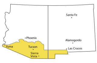
Southern Arizona is a region of the United States comprising the southernmost portion of the State of Arizona. It sometimes goes by the name Gadsden or Baja Arizona, which means "Lower Arizona" in Spanish.
Cerro is Spanish for "hill" or "mountain".
San Antonio is the seventh-most populous city in the United States and the second-most populous in the state of Texas.
Agua Caliente, Aguas Calientes or Aguascalientes may refer to:
Encantada may refer to:
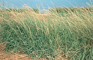
Bouteloua is a genus of plants in the grass family. Members of the genus are commonly known as grama grass.
Arizona Airways was an airline that was conceived as a regional airline to provide service to cities throughout the Southwestern United States and the Mexican state of Sonora from Texas to California. The airline was in service between 1993 and 1996.
The transportation system of Arizona comprises car, rail, air, bus, and bicycle transport.
Laredo–Nuevo Laredo, otherwise known as the "Four-State Area" or the "Quad State Area", is one of six transborder agglomerations along the U.S.-Mexican border. The city of Laredo is situated in the U.S. state of Texas on the northern bank of the Rio Grande and Nuevo Laredo is located in the Mexican State of Tamaulipas in the southern bank of the river. This area is also known as the Two Laredos or the Laredo Borderplex. The area is made up of one county in the U.S and three municipalities in Mexico. Two urban areas, three cities, and 12 towns make the Laredo–Nuevo Laredo Metropolitan area. The two sides of the Borderplex are connected by four International Bridges and an International Railway Bridge. The Laredo–Nuevo Laredo Metropolitan area has a total of 636,516 inhabitants according to the INEGI Census of 2010 and the United States Census estimate of 2010. According to World Gazetteer this urban agglomeration ranked 157th largest in North and South America in 2010 with an estimated population of 675,481. This area ranks 66th in the United States and 23rd in Mexico.
Cochise Airlines was a commuter airline which was founded in 1971 in Tucson, Arizona. It operated until the early 1980s. Cochise linked small cities in Arizona with Phoenix, Arizona and Tucson, Arizona and also served southern California and New Mexico at one point.
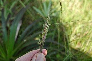
Piptochaetium, or speargrass, is a genus of plants in the grass family, native to North and South America. Piptochaetium is a bunchgrass genus in the tribe Stipeae.

An annular solar eclipse occurred at the Moon’s descending node of orbit on Saturday, October 14, 2023, with a magnitude of 0.952. A solar eclipse occurs when the Moon passes between Earth and the Sun, thereby totally or partly obscuring the image of the Sun for a viewer on Earth. An annular solar eclipse occurs when the Moon's apparent diameter is smaller than the Sun's, blocking most of the Sun's light and causing the Sun to look like an annulus (ring). An annular eclipse appears as a partial eclipse over a region of the Earth thousands of kilometres wide. Occurring about 4.6 days after apogee, the Moon's apparent diameter was smaller.

Southern Emigrant Trail, also known as the Gila Trail, the Kearny Trail, Southern Trail and the Butterfield Stage Trail, was a major land route for immigration into California from the eastern United States that followed the Santa Fe Trail to New Mexico during the California Gold Rush. Unlike the more northern routes, pioneer wagons could travel year round, mountain passes not being blocked by snows; however, it had the disadvantage of summer heat and lack of water in the desert regions through which it passed in New Mexico Territory and the Colorado Desert of California. Subsequently, it was a route of travel and commerce between the eastern United States and California. Many herds of cattle and sheep were driven along this route and it was followed by the San Antonio-San Diego Mail Line in 1857–1858 and then the Butterfield Overland Mail from 1858 to 1861.
The following is a timeline of the history of the city of Tijuana, Baja California, Mexico.

The following is a timeline of the history of the area which today comprises the U.S. state of Arizona. Situated in the desert southwest, for millennia the area was home to a series of Pre-Columbian peoples. By 1 AD, the dominant groups in the area were the Hohokam, the Mogollon, and the Ancestral Puebloans. The Hohokam dominated the center of the area which is now Arizona, the Mogollon the southeast, and the Puebloans the north and northeast. As these cultures disappeared between 1000 and 1400 AD, other Indian groups settled in Arizona. These tribes included the Navajo, Apache, Southern Paiute, Hopi, Yavapai, Akimel O'odham, and the Tohono O'odham.