Encanto, San Diego

Last updated
Encanto, San Diego
Encanto
View of O'Farrell Park and South Encanto from 61st Street, Southeast San Diego, California.jpg
View of Encanto from atop 61st Street, O'Farrell
SanDiegoSoutheastMap.gif
Encanto is located in the southeastern area of the city of San Diego
Location map Southern San Diego.png
Red pog.svg
Encanto, San Diego
Location within Southeast San Diego
Coordinates: 32°42′45″N117°03′40″W / 32.71250°N 117.06111°W / 32.71250; -117.06111
Country Flag of the United States.svg  United States of America
State Flag of California.svg  California
County Flag of San Diego County, California.png San Diego
City Flag of San Diego, California.svg San Diego
ZIP Code
92114

Encanto (Spanish for "Charm") is a hilly urban neighborhood located in the southeastern region of San Diego, California. The neighborhood is bordered by California State Route 94 and the communities of Oak Park and Broadway Heights to the north, O'Farrell (also known as South Encanto) to the south, Emerald Hills and Valencia Park to the west and the City of Lemon Grove to the east.

Contents

Background

The name Encanto usually refers to the neighborhood of Encanto, but it can also refer collectively to the neighborhoods of the Chollas Valley planning area, which consists of Alta Vista, Broadway Heights, Chollas View, Emerald Hills, Lincoln Park, O'Farrell, and Valencia Park, as well as Encanto.

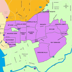
The citizens' community planning group that represents these eight neighborhoods in accordance with City of San Diego Council Policy 600-24 is named the Chollas Valley Community Planning Group.

Encanto is a predominantly low-density residential community, with commercial and industrial businesses located near major streets. Encanto and the adjacent neighborhoods are going through revitalization with such programs as the Chollas Creek Enhancement Program, which focuses on open space and restoring native vegetation.

Demographics

Encanto is a diverse community. Current demographics for the neighborhood are as follows: people of Hispanic heritage make up 47.6%, followed by Asian at 18.0%, then African-Americans at 17.5%, non-Hispanic Whites at 12.7%, Mixed Race at 3.8% and others at 0.4% [1]

Government

Encanto is within the 4th City Council District. [2] The district is currently represented by Monica Montgomery Steppe, who assumed office in 2018. [3] Federally, the neighborhood is within the California's 53rd congressional district. [4]

Education

Encanto is served primarily by the San Diego Unified School District along with some charter and private schools. Schools that serve O'Farrell students include The O'Farrell Charter Schools, an independent educational complex of charter school and the largest school in Encanto, along with Morse High School and Keiller Leadership Academy, a charter school partnered with the University of San Diego, both in bordering Skyline and Lincoln High School in nearby Lincoln Park.

Much like the rest of Southeast San Diego, many students in Encanto have taken advantage of San Diego Unified School District's Voluntary Enrollment Exchange Program (VEEP), and have opted to be bused to high schools in San Diego's more affluent northern suburban neighborhoods,. [5] Depending on their VEEP Allied School Pattern, a high school student may be voluntarily bused to Mira Mesa High School, Mission Bay High School, Scripps Ranch High School, Serra High School, and University City High School. [6]

Related Research Articles

City Heights is a dense urban community in central San Diego, California, known for its ethnic diversity. The area was previously known as East San Diego. City Heights is located south of Mission Valley and northeast of Balboa Park.

<span class="mw-page-title-main">Paradise Hills, San Diego</span> Community of San Diego in California

<span class="mw-page-title-main">Oak Park, San Diego</span> Community of San Diego in California

Oak Park is an urban neighborhood of the Southeast region of San Diego, California.

<span class="mw-page-title-main">Southeast San Diego</span> Community of San Diego in California

<span class="mw-page-title-main">O'Farrell Community School</span> Public charter school in San Diego, CA, United States

<span class="mw-page-title-main">Tony Young (politician)</span>

Tony Young is an American politician. He was the president of the city council of San Diego, California and served as a member of the council from 2005 to 2013, representing District 4. He is a Democrat, although the position is officially nonpartisan per California state law.

<span class="mw-page-title-main">Chollas View, San Diego</span> Neighborhood in San Diego, California

Chollas View is an urban community in the southeastern section of the city of San Diego. It is bordered by Webster and California State Route 94 on the north, Mount Hope and Interstate 805 on the west, Emerald Hills and Euclid Avenue on the east, and Lincoln Park and the San Diego Trolley on the south. Major thoroughfares include Market Street and 47th Street.

<span class="mw-page-title-main">Lincoln Park, San Diego</span> Community of San Diego in California

Lincoln Park is an urban community in the southeastern section of San Diego, California. It is bordered by Chollas View and the San Diego Trolley on the north, Mountain View and Interstate 805 on the west, Valencia Park and Euclid Avenue on the east, and National City, California on the south. Major thoroughfares include Imperial Avenue, Ocean View Boulevard, and Logan Avenue.

<span class="mw-page-title-main">Emerald Hills, San Diego</span> Community of San Diego in California

Emerald Hills is a neighborhood in the southeastern section of the city of San Diego, California, United States. It is bordered by Oak Park and California State Route 94 on the north, Chollas View and Euclid Avenue on the west, Encanto and Skyline Drive on the east, and Valencia Park and Market Street on the south. Major thoroughfares include Kelton Road and Roswell Street.

<span class="mw-page-title-main">Valencia Park, San Diego</span> Community of San Diego in California

Valencia Park is an urban community in the southeastern section of the city of San Diego. It is bordered by Emerald Hills and Market Street on the north, Lincoln Park and Euclid Avenue on the west, Encanto on the east, and Alta Vista and National City, California on the south. Major thoroughfares include Imperial Avenue, Churchward Street, and Valencia Parkway.

<span class="mw-page-title-main">2010 San Diego elections</span>

Municipal elections were held in San Diego in 2010 for city council and propositions. The primary election was held on June 8, 2010, and the general election was held on November 2, 2010. Four of the eight seats of the San Diego City Council were contested. This was the last election to use eight council districts. Two incumbents ran for reelection in their council district.

<span class="mw-page-title-main">2006 San Diego City Council election</span>

The 2006 San Diego City Council election occurred on November 7, 2006. The primary election was held on June 6, 2006. Four of the eight seats of the San Diego City Council were contested. All four incumbent council members stood for reelection.

<span class="mw-page-title-main">2002 San Diego City Council election</span>

The 2002 San Diego City Council election occurred on November 5, 2002. The primary election was held on March 5, 2002. Four of the eight seats of the San Diego City Council were contested. Two incumbent council members stood for reelection after having previously been elected to partial terms.

<span class="mw-page-title-main">Skyline, San Diego</span> Community of San Diego in California

Skyline, also known as Skyline Hills or Skyline Park, is a hilly urban neighborhood in Southeastern San Diego. It is bordered by Encanto to the west, Jamacha-Lomita to the North East, and Bay Terraces to the South. The neighborhood is split into two sections, Skyline West and Skyline East. The neighborhood is part of the Skyline-Paradise Hills Community Planning Area.

<span class="mw-page-title-main">Bay Terraces, San Diego</span> Community of San Diego in California

Bay Terraces is a hilly urban neighborhood in the southeastern part of San Diego, California, United States. A composite of North Bay Terrace and South Bay Terrace, it is bordered by Skyline to the north, Paradise Hills to the southwest, Alta Vista, South Encanto and National City to the west. The southern end of the neighborhood is bordered by State Route 54 and Bonita. The neighborhood generally includes the ZIP Codes 92114 and 92139 and as such, parts of the area have often been incorrectly referred to as either "Paradise Hills" or "Skyline Hills" due to its proximity and overlapping ZIP Codes. Nevertheless, Bay Terraces is the largest neighborhood in the Skyline-Paradise Hills Community Planning Area.

<span class="mw-page-title-main">Myrtle Cole</span>

Myrtle Cole is an American politician in San Diego, California. She was a member of the San Diego City Council representing City Council District 4 from 2013 until 2018. Cole served as president of the City Council from 2017 until 2018. In 2018 Cole lost a bid for reelection, becoming one of the first incumbent council members to lose a reelection campaign since 1992. She was the first African American woman elected to the city council. She is a Democrat, although city council positions are officially nonpartisan per California state law.

<span class="mw-page-title-main">2014 San Diego elections</span>

Municipal elections were held in San Diego in 2014 for city council and propositions. The primary election was held on June 3, 2014, and the general election was held on November 4, 2014. Four of the nine seats of the San Diego City Council were contested. Two city council incumbents ran for re-election in their same district and one ran for election in a new district due to redistricting.

<span class="mw-page-title-main">2018 San Diego City Council election</span>

The 2018 San Diego City Council election occurred on November 6, 2018. The primary election was held June 5, 2018. Four of the nine seats of the San Diego City Council were contested.

<span class="mw-page-title-main">Monica Montgomery Steppe</span> American politician

Monica Montgomery Steppe is an American politician in San Diego, California. She currently serves as a member of the San Diego City Council representing City Council District 4. She is a Democrat, although city council positions are officially nonpartisan per California state law. She serves on the board of the California Reparations Task Force.

<span class="mw-page-title-main">O'Farrell, San Diego</span> Community of San Diego in California

O'Farrell is the name of the urban region in Southeast San Diego that includes portions of Skyline, Encanto and Valencia Park. The area borders North Bay Terraces to the east and Alta Vista to the south.

References

  1. ""Race and Ethnicity in Encanto, San Diego, California"". Statistical Atlas. Retrieved 2020-11-20.
  2. San Diego (Calif.) (2000). San Diego Annual Budget. City Manager. p. 895.
  3. Garrick, David (November 7, 2018). "Cole, Zapf lose re-election bids in two rare instances of San Diego council incumbents being rejected". San Diego Union-Tribune. Retrieved November 17, 2020.
  4. "A Community of Contrasts" (PDF). Union of Pan Asian Communities. Asian Americans Advancing Justice, Los Angeles. 2015. Retrieved 4 October 2017.
  5. "VEEP Information". Archived from the original on 2007-12-10. Retrieved 2007-11-17.
  6. "2007–2008 VEEP Allied Patterns" (PDF). Archived from the original (PDF) on 2008-05-02. Retrieved 2007-11-17.

Commons-logo.svg Media related to Encanto, San Diego at Wikimedia Commons