The College Area is a neighborhood of the Mid-City region of San Diego, California, United States. The College Area is dominated by San Diego State University, after which the area is named. Several neighborhoods in the College Area were developed in the 1930s, with others becoming established in the post-war period. The College Area is bordered on the west by Kensington and Talmadge and on the east by the city of La Mesa. El Cajon Boulevard is a busy shopping district; additional retail is in development near SDSU.

Normal Heights is a neighborhood of the mid-city region of San Diego, California.
Del Cerro is a wealthy hilly residential neighborhood of approximately 2,300 residents in the eastern part of San Diego, California. Del Cerro borders the communities of San Carlos, Allied Gardens, College Area, Grantville, and the city of La Mesa, and is adjacent to Lake Murray and San Diego State University. For planning purposes the city includes it in the Navajo community planning area.
Logan Heights is a neighborhood in central San Diego, California. It is bordered by Interstate 5 on the south and west, Interstate 15 on the east, and Imperial Avenue on the north.

Bankers Hill, sometimes known as Park West, is a long established uptown San Diego neighborhood near Balboa Park. It is bordered to the north by Hillcrest, to the south, past Date Street, by Downtown, to the east by Balboa Park, and the west by Interstate 5, Little Italy and the neighborhood known as Midtown.

Paradise Hills is a neighborhood in the southeastern area of the city of San Diego, California. It is an outlying neighborhood adjacent to the independent city of National City and the unincorporated communities of Lincoln Acres and certain portions of Bonita.
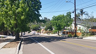
Talmadge is a neighborhood of the mid-city region of San Diego, California. Its borders are defined by Fairmount Avenue to the West, Montezuma Road/Collwood Boulevard to the Northeast, and El Cajon Boulevard to the South.
El Cerrito, Spanish for "the little hill," is a neighborhood of the Mid-City region of San Diego, California. El Cerrito is a residential neighborhood, consisting mostly of suburban homes, with some commercial activity along the streets that define its borders.
Redwood Village is a neighborhood of the Mid-City region of San Diego, California. Formerly known as Darnall, on June 7, 2007, residents voted to change the name of the neighborhood to Redwood Village. Redwood Village is a mostly residential neighborhood, with the exception of the area South of University avenue which is home to the University Square Shopping Center.
Rolando is a neighborhood of the Mid-City region of San Diego, California. Rolando is mostly residential with the exception of El Cajon Boulevard, which features the Campus Plaza shopping center. Rolando is divided by University Avenue into two sections: Rolando Village to the north, and Rolando Park to the south.
Cortez Hill is a neighborhood located in north-east Downtown San Diego, California.
North City is a neighborhood in San Diego, California bordered by Solana Beach and Rancho Santa Fe to the north, Del Mar Heights to the west, and Carmel Valley to the south. I-5 forms the western boundary. The name is almost never used by local residents as the area is already included in either Rancho Santa Fe or Carmel Valley. The name is almost exclusively used by the San Diego Police Department for zoning.
La Playa is a bayfront neighborhood in the Point Loma community of San Diego, California. It is bordered by the San Diego Bay on the east, Naval Base Point Loma on the south, the Wooded Area neighborhood to the west and Point Loma Village/Roseville-Fleetridge to the north. It lies across a channel from Shelter Island.
Nestor is a residential neighborhood in the southern section of San Diego, and part of the Otay Mesa-Nestor community planning area. It neighbors Palm City and Otay Mesa West to the east, Egger Highlands to the north, San Ysidro to the southeast and the Tijuana River Valley to the south. Major thoroughfares include Coronado Avenue, Saturn Boulevard, Hollister Street, and Tocayo Avenue.
Egger Highlands is a residential neighborhood in the southern section of San Diego. It neighbors Palm City and Nestor to the east, San Diego Bay to the north, Imperial Beach to the southwest and Chula Vista to the northeast. Major thoroughfares include Coronado Avenue, Saturn Boulevard, and Palm Avenue.
Otay Mesa West is a residential neighborhood in the southern section of San Diego. It borders Interstate 805 to the east, Interstate 5 to the west, and California State Route 905 to the south. It neighbors Ocean View Hills to the east, Nestor and Palm City to the west and Chula Vista to the north. The northern boundary of Otay Mesa West roughly coincides with the Otay River. Just north of the Otay River the community of Otay resides within the city of Chula Vista. Major thoroughfares include Palm Avenue, Coronado Avenue, Picador Boulevard, Del Sol Boulevard, Beyer Boulevard, and Beyer Way.

Mountain View is a community in the southeastern section of the city of San Diego. It is bordered by Mount Hope and Greenwood Memorial Park on the north, Interstate 15 and the neighborhoods of Stockton and Logan Heights on the west, Interstate 805 and Lincoln Park on the east, and Southcrest and National City on the south. Major thoroughfares include Imperial Avenue and Ocean View Boulevard.
Southcrest is a community in the southeastern section of the city of San Diego. It is bordered by Mountain View on the north and east, Interstate 5 and the neighborhoods of Barrio Logan and Logan Heights on the west, and Shelltown on the south. Major thoroughfares include National Avenue and 40th Street.
Lincoln Park is a community in the southeastern section of San Diego, California. It is bordered by Chollas View and the San Diego Trolley on the north, Mountain View and Interstate 805 on the west, Valencia Park and Euclid Avenue on the east, and National City, California on the south. Major thoroughfares include Imperial Avenue, Ocean View Boulevard, and Logan Avenue.
Fairmount Park is a neighborhood of San Diego, California. Its borders are defined by Interstate 15 to the west, Interstate 805 to the east and California Highway 94 to the south. Its neighboring communities are South Park and Golden Hill to the west, Azalea Park and City Heights to the east, and Webster to the south. It is primarily residential, mostly single-family homes, with a small commercial area along Home Avenue including several restaurants and convenience stores. Bayridge is a small neighborhood within Fairmount Park on its westernmost knoll, identifiable by its outstanding views and well-maintained townhouse development. Fairmount Park is 3 miles from Downtown San Diego. Chollas Creek runs through it.


