Poway is a city in San Diego County, California, United States. The unincorporated community became a city on December 1, 1980. Poway's rural roots influenced its motto "The City in the Country". The city has a population of 49,701 as of 2019.

North County is a region in the northern area of San Diego County, California. It is the second-most populous region in the county, with an estimated population of 869,322. North County is well known for its affluence, especially in Encinitas, Carlsbad, Del Mar, Rancho Santa Fe, and Solana Beach, where house prices range, on average, above $1,000,000. Cities along the 78 freeway have more mixed incomes.

State Route 56 (SR 56) is an east–west state highway in the U.S. state of California. It runs 9.210 miles (14.822 km) from Interstate 5 (I-5) in the Carmel Valley neighborhood of San Diego to I-15. The eastern terminus of the highway is also the western end of the Ted Williams Parkway. SR 56 serves as an important connector between I-5 and I-15, being the only east–west freeway between SR 78 in north San Diego County, several miles away, and SR 52 near Marine Corps Air Station Miramar. It is also named the Ted Williams Freeway, after the San Diego-born baseball player.

Area codes 619 and 858 are telephone area codes in the North American Numbering Plan (NANP) for most of San Diego County in the U.S. state of California.
Poway Unified School District is a school district located in Poway, California. The district operates 26 elementary schools, seven middle schools (6–8); five comprehensive high schools (9–12); and one continuation high school. Twenty-one of the district's schools are located in the city of San Diego; eleven others are in the city of Poway. The district serves approximately 33,000 students in San Diego County and is the third-largest school district in the county.

Carmel Valley is a suburban planned community in the northwestern corner of San Diego, California, United States. The community is composed of commercial offices, residential units, hotels, retail stores and restaurants.
Black Mountain Open Space Park is a city park located in the suburbs of San Diego, California.
California's 50th congressional district is a congressional district in the U.S. state of California, and encompasses parts of the Mid-Coast and northeastern parts of San Diego County. Scott Peters is currently the U.S. representative for California's 50th congressional district.

Rancho Bernardo is a master-planned community in the northern hills of the city of San Diego, California.
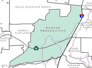
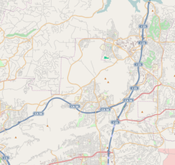
Rancho Peñasquitos is a suburban community in the northeastern part of the city of San Diego, California. It is named after the first Mexican land grant in the county, Rancho Santa Maria de Los Peñasquitos. Peñasquitos means "little cliffs" in Spanish. It abuts Los Peñasquitos Canyon Preserve, an open space preserve that offers hiking, biking, and equestrian trails. The community is commonly abbreviated "PQ."

Black Mountain Ranch is a suburban community in the northern part of the city of San Diego, California. Black Mountain Ranch encompasses 5,100 acres (21 km2) and is located north of Rancho Peñasquitos and Torrey Highlands, south of the Santa Fe Valley, east of Fairbanks Ranch and Rancho Santa Fe, and west of 4S Ranch.

4S Ranch is a locale of San Diego County, California. It is located about 25 miles (40 km) north of downtown San Diego and 13 miles (21 km) east of the Pacific Ocean in the North County Inland area of San Diego. To the east of 4S Ranch is the San Diego community of Rancho Bernardo. To the west is the Santa Fe Valley, which includes Rancho Santa Fe. Lake Hodges forms the northern border of the community while Black Mountain Ranch, which includes Del Sur and Santaluz, and Rancho Peñasquitos are both situated to the south. The ZIP Code is 92127, and the community is inside area code 858.
San Pasqual Valley, historically spelt as San Pascual, is the northernmost community of the city of San Diego. It is named for the Kumeyaay village of San Pasqual that was once located there. It is bordered on the north by the city of Escondido, on the east and west by unincorporated land within San Diego County, and on the south by the city of Poway and the community of Rancho Bernardo. San Pasqual Valley is home to the San Diego Zoo Safari Park.

Carmel Mountain Ranch, sometimes shortened to simply Carmel Mountain, or abbreviated to CMR by local residents and organizations is a community of San Diego, California, United States, in the northeastern part of the city. Despite its name, Carmel Mountain Ranch is actually in the shadow of Black Mountain. Carmel Mountain proper is about 10 miles west of the Carmel Mountain Ranch neighborhood.

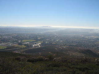
Torrey Highlands is a primarily residential community in northern San Diego, California. Most of the community has been developed from 2000 to present.
Rancho Santa Maria de Los Peñasquitos was a 8,486-acre (34.34 km2) Mexican land grant in present-day southwestern San Diego County, California given in 1823 to Francisco María Ruiz. The name means "Saint Mary of the Little Cliffs". It encompassed the present-day communities of Mira Mesa, Carmel Valley, and Rancho Peñasquitos in northern San Diego city, and was inland from the Torrey Pines State Natural Preserve bluffs.
Fairway Village is a neighborhood division of Carmel Mountain Ranch, located along Stoney Gate Place, parallel to Ted Williams Parkway and crossed by Shoal Creek Drive, in San Diego, California.

The 2008 San Diego City Council election occurred on November 4, 2008. The primary election was held on June 5, 2008. Four of the eight seats of the San Diego City Council were contested. This was the last election for the odd-numbered districts using the boundaries created by the 2000 Redistricting Committee. No incumbent council members were eligible to run for reelection due to term limits.
The 2004 San Diego City Council election occurred on November 2, 2004. The primary election was held on March 2, 2004. Four of the eight seats of the San Diego City Council were contested. This election used the boundaries created by the 2000 Redistricting Committee for the odd-numbered districts. All four incumbent council members ran for reelection in their respective districts.
Municipal elections were held in San Diego in 2020 for mayor, city attorney, and city council. The primary election occurred Tuesday, March 3, 2020, and the general election occurred Tuesday, November 3, 2020. Five of the nine council seats were contested. No council incumbents stood for reelection.