Pacific Beach, San Diego

Last updated
Pacific Beach, San Diego
Pacific Beach
Pacific Beach, San Diego.jpg
The beach at Pacific Beach looking south
Nickname: 
"P.B."
Location map Central San Diego.png
Red pog.svg
Pacific Beach, San Diego
Location within Central San Diego
Coordinates: 32°47′52″N117°14′25″W / 32.7978265°N 117.2403142°W / 32.7978265; -117.2403142
Country Flag of the United States.svg  United States of America
State Flag of California.svg  California
County Flag of San Diego County, California.png San Diego
City Flag of San Diego, California.svg San Diego

Pacific Beach is a neighborhood in San Diego, bounded by La Jolla to the north, Mission Beach and Mission Bay to the south, Interstate 5 and Clairemont to the east and the Pacific Ocean to the west. [1] While formerly largely populated by young people, surfers, and college students, because of rising property and rental costs the population is gradually becoming older and more affluent. [2] "P.B.," as it is known as by local residents, is home to one of San Diego's more developed nightlife scenes, with a great variety of bars, eateries, and clothing stores located along Garnet Avenue and Mission Boulevard.

Contents

History

Before European contact, the area was settled by the Kumeyaay people, who built a large village then known as Hamo, or Jamo, on the banks of Rose Creek at the entrance of Rose Canyon.

As with many California cities, the history of San Diego's development can be traced back to the completion of a cross-country railroad in 1885. [3] The town developed during the boom years between 1886 and 1888 by D. C. Reed, A. G. Gassen, Charles W. Pauley, R. A. Thomas, and O. S. Hubbell. It was Hubbell who "cleared away the grainfields, pitched a tent, mapped out the lots, hired an auctioneer and started to work". [4] A railway connected Pacific Beach with downtown San Diego starting in 1889, and was extended to La Jolla in 1894. [3]

Crystal Pier, originally constructed in 1927 Crystal Pier.jpg
Crystal Pier, originally constructed in 1927

Early landmarks and attractions in Pacific Beach included an asbestos factory (established in 1888), a race track, and the San Diego College of Letters (1887–1891), none of which survive today. [5] [3] At the turn of the century, lemon growing and packing dominated the local economy. [3] In 1910, the San Diego Army and Navy Academy, a preparatory school, was established in an old College building; in 1922 a public high school followed and a junior high in 1930. [3] In 1927, Crystal Pier opened; the Roxy Movie theater opened in 1943 to cater to a population that grew five times during World War II. [3] The postwar period saw the establishment of many hotels: the Bahia (1953), the Catamaran (1959), and Vacation Village (1965). [3] High-rise construction in nearby Mission Bay led to the establishment of a 30-foot height limitation for buildings in 1972, an ordinance still in effect. [3] Prominent boardwalk Ocean Avenue was closed in 1982 and became a park. [3]

In 1902, lots sold for between $350–700 for oceanfront property. By 1950, the population of Pacific Beach reached 30,000 and the average home sold for $12,000. [6] Nonetheless, a small number of farms remained. Today, homes can sell for millions of dollars.

In 1945, over 1,900 residents petitioned to remove the name of William Payne from the middle school because they did not believe that a black teacher deserved to be there. At the time, only two black families owned property in the neighborhood. In 2021, following a wave of name changes in the wake of the murder of George Floyd, the San Diego Unified School Board voted to rename a joint-use field at the middle school after Payne and his wife Fannie. [7]

The United States Navy operated an anti-aircraft training center at Pacific Beach during World War II. [8] During the 1960s, development continued to increase with the city's investment in Mission Bay Park, including the developments of the Islandia, Vacation Village and Hilton Hotels. In 1964, Sea World opened south of Pacific Beach.

The original name of this feature was "Bay Point" and today one may still find a USGS bench mark and associated RM (DC1025, DC1026 respectively) with that name there. [9] The "Bay Point Formation" is the name of a local rock strata first found and described there. [10]

Geography

The beach

looking down the cliffs overlooking Pacific Beach north of Crystal Pier Pacific Beach 5 2014-02-24.jpg
looking down the cliffs overlooking Pacific Beach north of Crystal Pier

The beach stretches for miles from the Mission Bay jetty to the cliffs of La Jolla. The boardwalk, officially called Ocean Front Walk/Ocean Boulevard, is a pedestrian walkway that runs approximately 3.2 miles along the beach from the end of Law St. in the north down into Mission Beach, ending at the mouth of Mission Bay in the south. There are numerous local shops, bars, hotels, and restaurants along the boardwalk, and it is generally crowded with pedestrians, cyclists, rollerbladers, skateboarders and shoppers. Adjacent to the boardwalk is the Crystal Pier, a public pier and hotel at the west end of Garnet Avenue. San Diego City Council banned the use of all electric-motor scooters in December 2019. [11]

Streets

The beach near the boardwalk and pier Pacific Beach 9 2014-02-24.jpg
The beach near the boardwalk and pier

The streets in Pacific Beach were renamed several times before receiving their current designations in 1900. [4] [3] The primary north-south street running parallel to the beach is Mission Blvd., with the streets named after late 19th century federal officials, then incrementing in alphabetical order as they move further from the coast: Bayard, Cass, Dawes, Everts, Fanuel, Gresham, Haines, Ingraham, Jewell, Kendall, Lamont, Morrell, Noyes, Olney, Pendleton, Quincy, and Randall. Mission Boulevard was formerly Allison Street, being the "A" street of the series. Ingraham was initially named Broadway (1887), then was changed to Izard (1900), back to Broadway (1907) and finally settled as Ingraham Street in 1913. [3]

The east-west streets are mostly named after precious stones. Starting at the north end of Mission Blvd. and heading south, the streets are:

Climate

Pacific Beach on an overcast day Pacific Beach southwards.JPG
Pacific Beach on an overcast day

Pacific Beach has a semi-arid subtropical climate (Köppen climate classification: BSk) with warm-summer Mediterranean characteristics. The sun shines more than 300 days each year in Pacific Beach, and rainfall averages less than 11 inches per year.

Climate data for Pacific Beach, San Diego
MonthJanFebMarAprMayJunJulAugSepOctNovDecYear
Record high °F (°C)89
(32)
91
(33)
95
(35)
99
(37)
101
(38)
103
(39)
108
(42)
104
(40)
108
(42)
107
(42)
97
(36)
87
(31)
108
(42)
Mean daily maximum °F (°C)65.6
(18.7)
65.7
(18.7)
65.8
(18.8)
68.3
(20.2)
69.0
(20.6)
71.0
(21.7)
74.5
(23.6)
76.0
(24.4)
75.5
(24.2)
72.6
(22.6)
69.1
(20.6)
65.2
(18.4)
69.9
(21.1)
Mean daily minimum °F (°C)48.9
(9.4)
50.6
(10.3)
53.1
(11.7)
55.8
(13.2)
59.5
(15.3)
61.9
(16.6)
65.4
(18.6)
66.7
(19.3)
64.7
(18.2)
60.5
(15.8)
53.6
(12.0)
48.5
(9.2)
57.4
(14.1)
Record low °F (°C)30
(−1)
32
(0)
39
(4)
40
(4)
47
(8)
51
(11)
57
(14)
57
(14)
54
(12)
42
(6)
36
(2)
34
(1)
30
(−1)
Average precipitation inches (mm)2.24
(57)
2.08
(53)
2.12
(54)
0.73
(19)
0.21
(5.3)
0.09
(2.3)
0.03
(0.76)
0.10
(2.5)
0.22
(5.6)
0.39
(9.9)
1.04
(26)
1.27
(32)
10.51
(267)
Source: [12] [13]

Parks and recreation

SurfPacificBeach.jpg
Pacific Beach Skyline.jpg
Surfing at Pacific Beach

In addition to bordering the Pacific Ocean and Mission Bay Park, Pacific Beach includes Kate Sessions Park and the Pacific Beach Recreation Center. Kate Sessions Park has a playground, a large lawn with ocean views, and a many-acre unmaintained area used for hiking and mountain biking. Fanuel Street Park is a popular bay-front park with playground equipment suitable for toddlers and school-age children. Rose Creek, which flows through Pacific Beach before emptying into Mission Bay, provides open space and a rich wetland area.

Surfing

Pacific Beach is open to all surfers. [14] The level of difficulty is intermediate and can be surfed all year. [15] The south wind makes surfing best though in the fall and winter. Many surfers wear dry or wetsuits as the water is in the high 50s in the winter and high 60s to low 70s in the summer. [16]

Organizations

The nonprofit Pacific Beach Town Council promotes the area and organizes community events. [17] Save Pacific Beach is residents working together to better the community. [18] The Pacific Beach Planning Group advises the city on land use and other issues. [19] The Pacific Beach and Mission Bay Visitor Center provides information on the Pacific Beach Town Council, special events, lodging, dining, and Pacific Beach history. [6] Service clubs include Kiwanis, Rotary, Lions Club, Girl Scouts, Pacific Beach Woman's Club, [20] Surf Club, Friends of the PB Library, PB Garden Club, and Toastmasters.

Education

Pacific Beach public schools are part of the San Diego Unified School District. They include Mission Bay Senior High School, Pacific Beach Middle School, Pacific Beach Elementary, Kate Sessions Elementary, Barnard Elementary, and Crown Point Junior Music Academy .

Media

Pacific Beach is serviced in print by the daily San Diego Union Tribune and the weekly Beach & Bay Press.

In John Dos Passos's The 42nd Parallel (1930), Fainy "Mac" McCreary briefly lives in a bungalow in Pacific Beach with his wife Maisie and their daughter Rose.

Love All You Have Left was filmed at a private residence in Pacific Beach. [21]

Notable people

See also

Related Research Articles

<span class="mw-page-title-main">Santa Cruz, California</span> City in California, United States

Santa Cruz is the largest city and the county seat of Santa Cruz County, in Northern California. As of the 2020 census, the city population was 62,956. Situated on the northern edge of Monterey Bay, Santa Cruz is a popular tourist destination, owing to its beaches, surf culture, and historic landmarks.

<span class="mw-page-title-main">Imperial Beach, California</span> City in California, United States

Imperial Beach is a residential beach city in San Diego County, California, with a population of 26,137 at the 2020 United States census, down from 26,324 at the 2010 census. The city is the southernmost city in California and the West Coast of the United States. It is in the South Bay area of San Diego County, 14.1 miles (22.7 km) south of downtown San Diego and 5 miles (8 km) northwest of downtown Tijuana, Mexico.

<span class="mw-page-title-main">La Jolla</span> Neighborhood in San Diego, California, United States

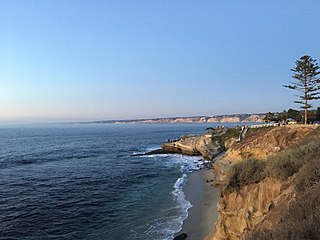
La Jolla is a hilly, seaside community within San Diego, occupying 7 miles (11 km) of curving coastline along the Pacific Ocean. The population reported in the 2010 census was 46,781. The climate is mild, with an average daily temperature of 70.5 °F (21.4 °C).

<span class="mw-page-title-main">Jersey Shore</span> Coastal region of the U.S. state of New Jersey

The Jersey Shore, commonly referred to locally as simply the Shore, is the coastal region of the U.S. state of New Jersey. Geographically, the term encompasses about 141 miles (227 km) of oceanfront bordering the Atlantic Ocean, from Perth Amboy in the north to Cape May Point in the south. The region includes Middlesex, Monmouth, Ocean, Atlantic, and Cape May counties, which are in the central and southern parts of the state. Located in the center of the Northeast Megalopolis, the northern half of the shore region is part of the New York metropolitan area, while the southern half of the shore region is part of the Philadelphia metropolitan area, also known as the Delaware Valley. The Jersey Shore hosts the highest concentration of oceanside boardwalks in the United States.

<span class="mw-page-title-main">Mission Beach, San Diego</span> Community of San Diego in California

Mission Beach is a community built on a sandbar between the Pacific Ocean and Mission Bay. It is part of the city of San Diego, California.

<span class="mw-page-title-main">Ocean Beach, San Diego</span> Community of San Diego in California, United States

Ocean Beach is a beachfront neighborhood of San Diego, California.

<span class="mw-page-title-main">Black's Beach</span> Nude beach near San Diego, California, United States

Black's Beach is a secluded section of beach beneath the bluffs of Torrey Pines on the Pacific Ocean in La Jolla, San Diego, California, United States. It is officially part of Torrey Pines State Beach. The northern portion of Black's Beach is owned and managed by the California Department of Parks and Recreation, while the southern portion of the beach, officially known as Torrey Pines City Beach, is jointly owned by the city of San Diego and the state park, but is managed by the city of San Diego. This distinction is important as Black's Beach is most known as a nude beach, a practice that is now prohibited in the southern portion managed by the city of San Diego.

<span class="mw-page-title-main">Torrey Pines State Beach</span> State park in California, United States

Torrey Pines State Beach is a public beach located in the San Diego, California community of Torrey Pines, south of Del Mar and north of La Jolla. Coastal erosion from the adjacent Torrey Pines State Reserve makes for a picturesque landscape. It is a local favorite among surfers and remains a quintessential Southern California beach. Occurrences of bioluminescence in the waters near the beach have been noted.

<span class="mw-page-title-main">Windansea Beach</span>

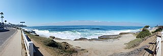
Windansea Beach is a stretch of coastline located in the La Jolla community of San Diego, California. The neighborhood adjacent to the beach is named Windansea after the beach. It is named after the 1909 oceanfront Strand Hotel that was renamed "Windansea" Hotel in 1919 after the owner Arthur Snell ran a "naming contest". The Windansea Hotel which was located on Neptune Avenue between Playa del Sur and Playa del Norte burned down in 1943. Geographically, it is defined by the beachfront extending north of Palomar Avenue and south of Westbourne Street.

<span class="mw-page-title-main">La Jolla Shores</span> Beach in La Jolla, San Diego, California

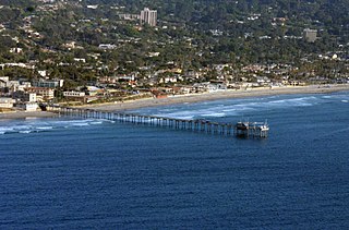
La Jolla Shores, with its northern part Scripps Beach, is a beach and vacation/residential community of the same name in La Jolla, San Diego, California. The La Jolla Shores business district is a mixed-use village encircling Laureate Park on Avenida de la Playa in the village of La Jolla Shores.

<span class="mw-page-title-main">Santa Monica State Beach</span> State beach in Los Angeles County, California, United States

Santa Monica State Beach is a California State Park operated by the city of Santa Monica.

Surf Diva is recognized internationally as Southern California’s original all-women's surf school.

<span class="mw-page-title-main">Marine Street Beach</span> Public beach in La Jolla, San Diego, California

Marine Street Beach is a public beach located in the community of La Jolla in San Diego, California, on the Pacific Ocean. It sits at the western terminus of Marine Street, with Children's Pool Beach to the north and Windansea Beach to the south. The surf has been described as rough and not suitable for children. However, the rough surf has made the beach popular with surfers and bodyboarders. Nearby kelp beds host marine life making the area a popular dive spot.

<span class="mw-page-title-main">Leucadia, Encinitas, California</span> Neighborhood of Encinitas in San Diego, California, United States

Leucadia is a beach community located in the coastal city of Encinitas, California. Leucadia is known for the relatively secluded beaches in Southern California surf culture.

Bird Rock is a seaside neighborhood within the larger community of La Jolla in San Diego, California. It lies on the Pacific Ocean at the southernmost end of La Jolla, just north of Pacific Beach. The mostly residential neighborhood includes homes for 1,400 to 1,500 families, with a commercial district along the main street, La Jolla Boulevard. The shore is rocky and has no beach, but offshore reefs are used for surfing.

<span class="mw-page-title-main">Tourmaline Surfing Park</span> Beach access point and surf spot in San Diego, California

Tourmaline Surfing Park is a beach access point and a surf spot in North Pacific Beach, San Diego, California, USA. The park is situated at the northern end of Pacific Beach, a short distance south of where the sand beach ends and the rocky promontory of La Jolla begins. There are cliffs to the north and south of Tourmaline Surfing Park, but the park itself lies in Tourmaline Canyon, which cuts down through those cliffs to the beach.

<span class="mw-page-title-main">George Floyd protests in San Diego County, California</span> 2020 civil unrest after the murder of George Floyd

This is a list of protests that took place in San Diego County, California following the murder of George Floyd that took place on May 25, 2020 in Minneapolis, Minnesota, after police officer Derek Chauvin knelt on his neck for 9 minutes and 29 seconds. These events were created to fight for justice for George Floyd and other Black community members who suffer from Police brutality. These demonstrations resulted in a number of policy changes, namely the ban of the cartoid neck restraints use in San Diego County and a city-wide independent review board that would review police practices.

<span class="mw-page-title-main">Kate Sessions Memorial Park</span> Park in San Diego, California, U.S.

Kate Sessions Memorial Park is local public park situated at the base of Mount Soledad, in the City of San Diego, California. It hosts walking trails, picnic tables, BBQs, natural habitat, rest rooms, a seasonal creek, playground and dog friendly spaces. On clear days, it provides astonishing panoramic views of Mission Bay, the Pacific Ocean, Pacific Beach, Mission Beach, Ocean Beach, downtown San Diego and glimpses of San Diego Bay and Coronado.

References

  1. "Community Profiles Pacific Beach - City of San Diego Official Website". www.sandiego.gov. Retrieved 15 April 2018.
  2. "Pacific Beach". www.sandiego.com. 10 July 2011. Retrieved 2018-02-09.
  3. 1 2 3 4 5 6 7 8 9 10 11 Fry, John (1987). A Short History of Pacific Beach. Pacific Beach: John Fry Productions.
  4. 1 2 "Locker, Z.B., "Whatever happened to Izard Street?" Journal of San Diego History, 1976". sandiegohistory.org. Retrieved 15 April 2018.
  5. Fetzer, Leland (2005). San Diego County Place Names A to Z. San Diego: Sunbelt Publications. p. 108. In 1869, the site of the district's first race track, Agricultural Park ... promoters founded Pacific Beach Subdivision in 1887. Here they erected the San Diego College of Letters ... When it failed, its buildings became the Hotel Balboa.
  6. 1 2 Pacific Beach and Mission Bay Visitor Center Archived 2013-01-05 at archive.today
  7. Taketa, Kristen (2021-03-10). "San Diego Unified changes name of Junipero Serra High School, removes conquistador mascot". San Diego Union-Tribune. Retrieved 2021-03-10.
  8. "U.S. Naval Activities World War II by State". Patrick Clancey. Retrieved 2012-03-19.
  9. "NGS Datasheet Datasheet Page". Archived from the original on 2014-11-06. Retrieved 2015-03-10.
  10. Valentine, James William (1 July 1959). "The Bay Point Formation at its type locality (Calif), (Part) 1 of Pleistocene molluscan notes". Journal of Paleontology. 33 (4): 685–688. Retrieved 15 April 2018 via jpaleontol.geoscienceworld.org.
  11. "San Diego bans e-scooters along the boardwalk from Mission Beach to La Jolla". 17 December 2019. Retrieved 3 March 2020.
  12. "Zipcode 92109". www.plantmaps.com. Retrieved April 11, 2021.
  13. "Climate in Zip 92109". www.bestplaces.net. Retrieved July 26, 2023.
  14. "Surf in San Diego: Why Surf Pacific Beach?". San Diego Surf Lessons | All Ages Surfing School in San Diego 4 Beaches. 2019-09-05. Retrieved 2021-10-05.
  15. "Pacific Beach Surfing". RootsRated. 2016-04-22. Retrieved 2021-10-05.
  16. "Pacific Beach Surf Report, Live Surf Cams & 16-Day Surf Forecast". Surfline. Retrieved 2021-10-05.
  17. "Pacific Beach Town Council". www.pbtowncouncil.org. Retrieved 15 April 2018.
  18. "About Us". Save Pacific Beach. Retrieved 9 August 2023.
  19. "Pacific Beach Planning Group - City of San Diego Official Website". www.sandiego.gov. Retrieved 15 April 2018.
  20. "Pacific Beach Woman's Club". www.pbwomansclub.org. Retrieved 1 January 2021.
  21. Elling, Regina (2023-10-03). "Pacific Beach residents star in horror comedy perfect for Halloween". PB Monthly. Retrieved 2023-10-08.
To the North:
La Jolla
California beaches To the South
Mission Beach
To the North:
Tourmaline Surfing Park
California beaches To the South
Mission Beach, San Diego