Lincoln Park, San Diego

Last updated
Lincoln Park, San Diego
Lincoln Park
View from 47th Street, Lincoln Park, Southeast San Diego, California.jpg
View of the 43rd St On-Ramp of Interstate 805, from 47th Street, Lincoln Park
Nickname(s): 
"L.P.", "The Dip" (in reference to the densely populated stretch of Logan Ave between 47th St and Euclid Ave) [1]
SanDiegoSoutheastMap.gif
Lincoln Park is located in the southeastern area of the city of San Diego
Location map Southern San Diego.png
Red pog.svg
Lincoln Park, San Diego
Location within San Diego
Coordinates: 32°42′00″N117°05′25″W / 32.70000°N 117.09028°W / 32.70000; -117.09028 Coordinates: 32°42′00″N117°05′25″W / 32.70000°N 117.09028°W / 32.70000; -117.09028
Country Flag of the United States.svg  United States of America
State Flag of California.svg  California
County Flag of San Diego County, California.png San Diego
City Flag of San Diego, California.svg San Diego
ZIP Code
92113

Lincoln Park is an urban community in the southeastern section of San Diego, California. It is bordered by Chollas View and the San Diego Trolley on the north, Mountain View and Interstate 805 on the west, Valencia Park and Euclid Avenue on the east, and National City, California on the south. Major thoroughfares include Imperial Avenue, Ocean View Boulevard, and Logan Avenue.

Contents

History

The oldest section of Lincoln Park is the residential section between Imperial Avenue and Ocean View Boulevard. California State Route 157 was planned to run through Lincoln Park as an expressway, but that concept has been abandoned. [2]

Demographics

Lincoln Park is a diverse community. Current demographics for the neighborhood are as follows: people of Hispanic heritage make up 61.0%, followed by African-American at 18.9%, then Asian at 11.8%, Other race at 4.3%, non-Hispanic Whites at 3.0%, and Mixed Race at 1.0%. [3] It ranked near the bottom at 122 out of 125 San Diego neighborhoods in terms of lowest percentage of non-Hispanic whites, and 3 out of 125 San Diego neighborhoods in terms of total population that is non-White (roughly 97%), only to be surpassed by San Ysidro and Southcrest. [4]

Image

Lincoln Park has gone through decades of criminal trauma, including drug sales, gang violence, and homicide, often related to ongoing gang feuds with other Southeast San Diego neighborhoods, among them, the East Side Pirus of Skyline. [5] The intersection of Euclid Ave and Imperial Ave has long been considered "The Four Corners of Death" due to the staggering number of deaths that have occurred in and around the area, as well as it serving as an unofficial boundary to several gangs territories. Of the county's estimated 88 gangs, at least 50 operate within a few square miles of this intersection. [6]

According to data reported by the San Diego Police Department, 1,600 crimes were reported in the area from 2013 through 2019, with overall crime increasing by about 33 percent. [7]

Lincoln Park native, Mitchy Slick performing in 2010 Talib & Strong Arm Steady (5256047954) (cropped).jpg
Lincoln Park native, Mitchy Slick performing in 2010

In 2010, Lincoln Park along with nearby Southeast San Diego neighborhood, Logan Heights, were featured on The History Channel's Gangland television series. [8] [9] The Lincoln Park Bloods were featured on the Season 7 episode titled, "Vendetta of Blood" which first aired on May 14, 2010. [10]

Lincoln Park native, Nick Cannon at the 2010 Time 100 Gala Nick Cannon by David Shankbone.jpg
Lincoln Park native, Nick Cannon at the 2010 Time 100 Gala

One of the main centers of gang activity in Lincoln Park revolve around "The Dip", [11] a densely populated stretch of Logan Ave between 47th St and Euclid Ave. Central to the area is the sprawling Bay Vista Housing Projects (now known as Sea Breeze Gardens) [12] which appear extensively in the Gangland episode featuring Lincoln Park. Notable actor and rapper, Nick Cannon grew up in the neighborhood and experienced a great deal of violence in his childhood, noting his refusal to glorify that aspect of his life because he had lost a lot of friends to "senseless gang violence." [13] Prolific Underground Hip Hop artist and fellow Lincoln Park native, Mitchy Slick, noted Nick Cannon's father as an original member of the Lincoln Park Bloods. [14]

Rallies for peace in Lincoln Park have occurred periodically over the years, calling for the end of gang violence for all of Southeast San Diego, with more recent efforts to revitalize the area through the arts geared towards ending the negative stigma of Euclid and Imperial and reclaiming the deadly street intersection as "The Four Corners of Life." [15]

Landmarks and facilities

Chollas Creek runs through Lincoln Park.

Education

Abraham Lincoln High School in Lincoln Park Lincoln High School, on the intersection of Imperial Ave. and Willie James Jones Ave.jpg
Abraham Lincoln High School in Lincoln Park

Lincoln Park is served by the San Diego Unified School District along with some charter and private schools. Public schools in Lincoln Park include Lincoln High School, and John F. Kennedy and Knox Elementary Schools, as well as St. Rita's Catholic School.

Much like the rest of Southeast San Diego, many students in Lincoln Park have taken advantage of San Diego Unified School District's Voluntary Enrollment Exchange Program (VEEP), and have opted to be bused to high schools in San Diego's more affluent northern suburban neighborhoods,. [16] Depending on their VEEP Allied School Pattern, a high school student may be voluntarily bused to Mira Mesa High School, Mission Bay High School, Scripps Ranch High School, Serra High School, and University City High School. [17]

Related Research Articles

<span class="mw-page-title-main">Richmond District, San Francisco</span> Neighborhood in San Francisco, California, United States

The Richmond District is a neighborhood in the northwest corner of San Francisco, California, developed initially in the late 19th century. It is sometimes confused with the city of Richmond, which is 20 miles (32 km) northeast of San Francisco.

City Heights is a dense urban community in central San Diego, California, known for its ethnic diversity. The area was previously known as East San Diego. City Heights is located south of Mission Valley and northeast of Balboa Park.

The western border of Santa Monica, California, is the 3-mile (4.8 km) stretch of Santa Monica Bay. On its other sides, the city is bordered by various districts of Los Angeles: the northwestern border is Pacific Palisades, the eastern border is Brentwood north of Wilshire Boulevard and West Los Angeles south of Wilshire, the northeastern border is generally San Vicente Boulevard up to the Riviera Country Club, the southwestern border is Venice Beach and the southern border is with West Los Angeles and Mar Vista.

<span class="mw-page-title-main">University Heights, San Diego</span> Community of San Diego in California

University Heights is a neighborhood in Central San Diego, California centered on Park Boulevard and Adams Avenue. University Heights is bounded on the west and north by the edge of the mesa, the southern boundary is Lincoln Avenue, and the eastern boundary is Boundary Street along the western edge of Interstate 805. The area is filled with a number of restaurants, coffee shops, boutiques, and artist studios primarily on Park Boulevard and Adams Avenue. Live entertainment can be found most nights. Adjacent to Hillcrest, Normal Heights and North Park, additional restaurants, bars, coffee shops, and night clubs are within easy reach.

<span class="mw-page-title-main">Paradise Hills, San Diego</span> Community of San Diego in California

Paradise Hills is an urban neighborhood in the southeastern area of the city of San Diego, California. It is an outlying neighborhood adjacent to the independent city of National City and the unincorporated communities of Lincoln Acres and certain portions of Bonita. The neighborhood is part of the Skyline-Paradise Hills Community Planning Area.

<span class="mw-page-title-main">Encanto, San Diego</span> Community of San Diego in California

Encanto is a hilly urban neighborhood located in the southeastern region of San Diego, California. The neighborhood is bordered by California State Route 94 and the communities of Oak Park and Broadway Heights to the north, O'Farrell to the south, Emerald Hills and Valencia Park to the west and the City of Lemon Grove to the east.

<span class="mw-page-title-main">Mitchy Slick</span> American rapper

Charles Mitchell, known professionally as Mitchy Slick, is an American rapper from Southeast San Diego, California. He is a member of the rap supergroup Strong Arm Steady, along with rappers Phil Da Agony and Krondon. He performs solo with three albums released in addition to many collaborations. Mitchell is the CEO of Wrongkind Records.

<span class="mw-page-title-main">Oak Park, San Diego</span> Community of San Diego in California

Oak Park is an urban neighborhood of the Southeast region of San Diego, California.

<span class="mw-page-title-main">Morse High School (California)</span> School in San Diego, California, United States

Samuel F. B. Morse High School is an urban public high school located in southeastern San Diego in the neighborhood of Skyline Hills serving grades 9–12 in the American K-12 education system. Morse, which serves a predominantly socioeconomically-disadvantaged student population, has produced several notable athletes among its alumni

<span class="mw-page-title-main">Southeast San Diego</span> Community of San Diego in California

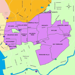
Southeast San Diego refers to the southeastern portion of the City of San Diego, including the neighborhoods south of State Route 94 and east of Downtown San Diego. Southeast San Diego has no official definition, but it may be considered coterminous with three official planning areas: Skyline-Paradise Hills, Encanto Neighborhoods, and Southeastern.

<span class="mw-page-title-main">47th Street station (San Diego Trolley)</span> San Diego Trolley station

47th Street station is a station on the Orange Line of the San Diego Trolley located in the Chollas View neighborhood San Diego, California. The station primarily serves this mixed-income residential area and includes a park and ride lot.

<span class="mw-page-title-main">Shelltown, San Diego</span> Community of San Diego in California

Shelltown is a neighborhood located within Southeast San Diego, approximately 5 minutes from downtown San Diego by car and 25 minutes by bicycle. It is bordered by National City on the south, Interstate 5 and Barrio Logan on the west, 43rd Avenue on the east, and Gamma Court and the neighborhood of Southcrest on the north. Prior to the 1980s the northern border of Shelltown was National Ave and many residents still consider that the northern border.

The Logan Heights Gang, also known as Varrio Logan Heights or LH, is a Sureño street gang based in Southeast San Diego.

<span class="mw-page-title-main">Southcrest, San Diego</span> Community of San Diego in California

Southcrest is an urban community in the southeastern section of the city of San Diego. It is bordered by Mountain View on the north and east, Interstate 5 and the neighborhoods of Barrio Logan and Logan Heights on the west, and Shelltown on the south. Major thoroughfares include National Avenue and 40th Street.

<span class="mw-page-title-main">Chollas View, San Diego</span> Neighborhood in San Diego, California

Chollas View is an urban community in the southeastern section of the city of San Diego. It is bordered by Webster and California State Route 94 on the north, Mount Hope and Interstate 805 on the west, Emerald Hills and Euclid Avenue on the east, and Lincoln Park and the San Diego Trolley on the south. Major thoroughfares include Market Street and 47th Street.

<span class="mw-page-title-main">Emerald Hills, San Diego</span> Community of San Diego in California

Emerald Hills is a neighborhood in the southeastern section of the city of San Diego, California, United States. It is bordered by Oak Park and California State Route 94 on the north, Chollas View and Euclid Avenue on the west, Encanto and Skyline Drive on the east, and Valencia Park and Market Street on the south. Major thoroughfares include Kelton Road and Roswell Street.

<span class="mw-page-title-main">Valencia Park, San Diego</span> Community of San Diego in California

Valencia Park is an urban community in the southeastern section of the city of San Diego. It is bordered by Emerald Hills and Market Street on the north, Lincoln Park and Euclid Avenue on the west, Encanto on the east, and Alta Vista and National City, California on the south. Major thoroughfares include Imperial Avenue, Churchward Street, and Valencia Parkway.

<span class="mw-page-title-main">Skyline, San Diego</span> Community of San Diego in California

Skyline, also known as Skyline Hills or Skyline Park, is a hilly urban neighborhood in Southeastern San Diego. It is bordered by Encanto to the west, Jamacha-Lomita to the North East, and Bay Terraces to the South. The neighborhood is split into two sections, Skyline West and Skyline East. The neighborhood is part of the Skyline-Paradise Hills Community Planning Area.

<span class="mw-page-title-main">Bay Terraces, San Diego</span> Community of San Diego in California

Bay Terraces is a hilly urban neighborhood in the southeastern part of San Diego, California, United States. A composite of North Bay Terrace and South Bay Terrace, it is bordered by Skyline to the north, Paradise Hills to the southwest, Alta Vista, South Encanto and National City to the west. The southern end of the neighborhood is bordered by State Route 54 and Bonita. The neighborhood generally includes the ZIP Codes 92114 and 92139 and as such, parts of the area has often been incorrectly referred to as either "Paradise Hills" or "Skyline Hills" due to its proximity and overlapping ZIP Codes. Nevertheless, Bay Terraces is the largest neighborhood in the Skyline-Paradise Hills Community Planning Area.

Monica Montgomery Steppe is an American politician in San Diego, California. She currently serves as a member of the San Diego City Council representing City Council District 4. She is a Democrat, although city council positions are officially nonpartisan per California state law. She serves on the board of the California Reparations Task Force.

References

  1. ""Problems at This Lincoln Park Strip Mall Keep Getting Worse Despite City Intervention"". Voice of San Diego. 2018-08-23. Retrieved 2020-11-21.
  2. Southeastern San Diego Community Plan
  3. ""Race and Ethnicity in Lincoln Park, San Diego, California"". Statistical Atlas. Retrieved 2020-11-20.
  4. ""Race and Ethnicity in Lincoln Park, San Diego, California"". Statistical Atlas. Retrieved 2020-11-20.
  5. "PEOPLE V. THOMAS". Casemine. Retrieved 2020-11-21.
  6. ""It's a War Zone Down Here." An exploration of the significantly high murder rates in Southeast San Diego"". San Diego Magazine. 2012-02-17. Retrieved 2020-11-20.
  7. ""Residents trying to revitalize a San Diego community call it 'The Four Corners of Life'"". San Diego Union-Tribune. 2020-09-27. Retrieved 2020-11-20.
  8. "Gangland episode guide" . Retrieved 2011-07-21.
  9. "Gangland episode guide". Archived from the original on 2012-10-05. Retrieved 2011-07-21.
  10. "Gangland: The Assassins" . Retrieved 2011-07-21.
  11. ""Problems at This Lincoln Park Strip Mall Keep Getting Worse Despite City Intervention"". Voice of San Diego. 2018-08-23. Retrieved 2020-11-21.
  12. "SEA BREEZE APARTMENTS". HUD. Retrieved 2020-11-29.
  13. ""NICK CANNON DESCRIBES UPBRINGING IN BLOOD GANG NEIGHBORHOOD"". Hip Hop DX. 2014-04-09. Retrieved 2020-11-21.
  14. "Mitchy Slick: Nick Cannon's Father Is One Of The Original Lincoln Park Bloods (Big Homies)". DoggieDiamondsTV. 2018-05-24. Retrieved 2020-11-21.
  15. ""Residents trying to revitalize a San Diego community call it 'The Four Corners of Life'"". San Diego Union-Tribune. 2020-09-27. Retrieved 2020-11-20.
  16. "VEEP Information". Archived from the original on 2007-12-10. Retrieved 2007-11-17.
  17. "2007–2008 VEEP Allied Patterns" (PDF). Archived from the original (PDF) on 2008-05-02. Retrieved 2007-11-17.