
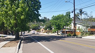
The College Area is a residential community in the Mid-City region of San Diego, California, United States. The College Area is dominated by San Diego State University, after which the area is named. Several neighborhoods in the College Area were developed in the 1930s, with others becoming established in the post-war period. The College Area is bordered on the west by Kensington and Talmadge and on the east by the city of La Mesa. El Cajon Boulevard is a busy shopping district; additional retail, entertainment and dining establishments are located in a new housing and commercial complex known as South Campus Plaza on College Avenue at Aztec Center. The College Area includes the neighborhoods of the Catoctin Area, Dennstedt Point, East Falls View Drive, Saranac-Mohawk, and an Orthodox Jewish neighborhood in the area near Congregation Beth Jacob Orthodox Synagogue on College Avenue. The region includes Alvarado Hospital, a 306-bed acute care facility, and the College-Rolando branch of the San Diego Public Library.
City Heights is a dense urban community in central San Diego, California, known for its ethnic diversity. The area was previously known as East San Diego. City Heights is located south of Mission Valley and northeast of Balboa Park.

Normal Heights is a neighborhood of the mid-city region of San Diego, California.
Del Cerro is a hilly residential neighborhood of approximately 2,300 residents in the eastern part of San Diego, California. Del Cerro borders the communities of San Carlos, Allied Gardens, College Area, Grantville, and the city of La Mesa, and is adjacent to Lake Murray and San Diego State University.

University City (UC) is a community in San Diego, California, located in the northwestern portion of the city next to the University of California, San Diego. University City is bordered by La Jolla and Interstate 5 to the west, Miramar and Interstate 805 to the east, and North Clairemont and Highway 52 to the south, giving the community a triangular-shaped boundary. University City is a part of District 1, which is represented by Councilmember Joe LaCava on the San Diego City Council.
Allied Gardens is a residential neighborhood in the eastern Navajo community of San Diego, California. It neighbors San Carlos to the east, Del Cerro to the south, the College Area to the southeast and Grantville to the southwest.

Kensington is a neighborhood of San Diego, California. Its borders are defined by Interstate 15 to the west, Interstate 8 to the north, Fairmount Avenue to the east, and El Cajon Boulevard to the south. Its neighboring communities are Normal Heights to the west, and City Heights to the south. Kensington is part of San Diego City Council District 9. In the United States House of Representatives, Kensington is in California's 53rd congressional district, represented by Democrat Sara Jacobs. Due to redistricting, it will become part of the 51st district after the 2022 congressional election.
Talmadge is a neighborhood of the mid-city region of San Diego, California. Its borders are defined differently by various planning agencies, but typically include Fairmount Avenue to the west, Montezuma Road to the north, Collwood Boulevard or 51st Street to the east, and Monroe Avenue or El Cajon Boulevard to the South.

San Carlos is a neighborhood in the eastern area of San Diego, California. It borders the neighborhoods of Del Cerro, Tierrasanta, Allied Gardens, the city of La Mesa, and Mission Trails Regional Park. The neighborhood extends to Cowles Mountain at the north.
Navajo is a hilly community in San Diego, California near East County. It is a designated planning area for the city of San Diego. It includes the neighborhoods of Del Cerro, Grantville, San Carlos, and Allied Gardens.

Clairemont is a community within the city of San Diego, California, United States. It has a population of about 81,600 residents and an area of roughly 13.3 square miles (34 km2). Clairemont Mesa is bordered by Interstate 805 on the east, Interstate 5 to the west, State Route 52 to the north, and the community of Linda Vista to the south. The community of Clairemont Mesa can be subdivided into the neighborhoods of North Clairemont, Clairemont Mesa East, Clairemont Mesa West, Bay Park, and Bay Ho.

Cortez Hill is a neighborhood located in the northeast part of Downtown San Diego, California.
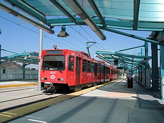
Grantville station is a station on San Diego Trolley's Green Line in the middle class residential Grantville neighborhood of San Diego, California. It is one of the San Diego Trolley network's newer stations, having opened in 2005.

The Midway area, also referred to as the North Bay area, is a neighborhood of San Diego, California. It is located at the northern (mainland) end of the Point Loma peninsula, northwest of Downtown San Diego and just west of Old Town. It is often considered to be part of Point Loma, although the city treats it as a separate Planning Area.

Emerald Hills is a neighborhood in the southeastern section of the city of San Diego, California, United States. It is bordered by Oak Park and California State Route 94 on the north, Chollas View and Euclid Avenue on the west, Encanto and Skyline Drive on the east, and Valencia Park and Market Street on the south. Major thoroughfares include Kelton Road and Roswell Street.
Fairmount Park is a neighborhood of San Diego, California. Its borders are defined by Interstate 15 to the west, Interstate 805 to the east and California Highway 94 to the south. Its neighboring communities are South Park and Golden Hill to the west, Azalea Park and City Heights to the east, and Webster to the south. It is primarily residential, mostly single-family homes, with a small commercial area along Home Avenue including several restaurants and convenience stores. Bayridge is a small neighborhood within Fairmount Park on its westernmost knoll, identifiable by its outstanding views and well-maintained townhouse development. Fairmount Park is 3 miles from Downtown San Diego. Chollas Creek runs through it.
Civita is a master-planned community in the Mission Valley area of the city of San Diego, San Diego County, United States. Located on a former quarry site, the urban-style, sustainable, transit-oriented 230-acre (93 ha) village is organized around a 14.3-acre (5.8 ha) community park that cascades down the terraced property.


