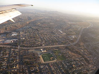
The College Area is a residential community in the Mid-City region of San Diego, California, United States. The College Area is dominated by San Diego State University, after which the area is named. Several neighborhoods in the College Area were developed in the 1930s, with others becoming established in the post-war period. The College Area is bordered on the west by Kensington and Talmadge and on the east by the city of La Mesa. El Cajon Boulevard is a busy shopping district; additional retail., entertainment and dining establishments are located in a new housing and commercial complex known as South Campus Plaza on College Avenue at Aztec Center. The College Area includes the neighborhoods of the Catoctin Area, Dennstedt Point, East Falls View Drive, Saranac-Mohawk, and an Orthodox Jewish neighborhood in the area near Congregation Beth Jacob Orthodox Synagogue on College Avenue. The region includes Alvarado Hospital, a 306-bed acute care facility, and the College-Rolando branch of the San Diego Public Library.

City Heights is a dense urban community in central San Diego, California, known for its ethnic diversity. The area was previously known as East San Diego. City Heights is located south of Mission Valley and northeast of Balboa Park.

Black Mountain Ranch is a suburban community in the northern part of the city of San Diego, California. Black Mountain Ranch encompasses 5,100 acres (21 km2) and is located north of Rancho Peñasquitos and Torrey Highlands, south of the Santa Fe Valley, east of Fairbanks Ranch and Rancho Santa Fe, and west of 4S Ranch.

San Carlos is a neighborhood in the eastern area of San Diego, California. It borders the neighborhoods of Del Cerro, Tierrasanta, and Allied Gardens, the city of La Mesa, and Mission Trails Regional Park. The neighborhood extends to Cowles Mountain at the north.
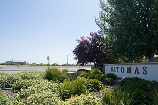
Natomas is a community in northwestern Sacramento, in the U.S. state of California.

Clairemont is a community within the city of San Diego, California, United States. It has a population of about 81,600 residents and an area of roughly 13.3 square miles (34 km2). Clairemont Mesa is bordered by Interstate 805 on the east, Interstate 5 to the west, State Route 52 to the north, and the community of Linda Vista to the south. The community of Clairemont Mesa can be subdivided into the neighborhoods of North Clairemont, Clairemont Mesa East, Clairemont Mesa West, Bay Park, and Bay Ho.
El Cerrito, Spanish for "the little hill," is a neighborhood of the Mid-City region of San Diego, California. El Cerrito is a residential neighborhood, consisting mostly of suburban homes, with some commercial activity along the streets that define its borders.
Redwood Village is a neighborhood of the Mid-City region of San Diego, California. Formerly known as Darnall, on June 7, 2007, residents voted to change the name of the neighborhood to Redwood Village. Redwood Village is a mostly residential neighborhood, with the exception of the area South of University avenue which is home to the University Square Shopping Center.
Rolando is a neighborhood of the Mid-City region of San Diego, California. Rolando is mostly residential with the exception of El Cajon Boulevard, which features the Campus Plaza shopping center. Rolando is divided by University Avenue into two sections: Rolando Village to the north, and Rolando Park to the south.
The city of San Antonio in the U.S. state of Texas is composed of a number of neighborhoods and districts, spreading out surrounding the central Downtown Area.

Southeast San Diego refers to the southeastern portion of the City of San Diego and the neighborhoods south of State Route 94 and east of Downtown San Diego. There are three official community planning areas: Skyline-Paradise Hills, Encanto Neighborhoods, and Southeastern.
Victory Boulevard is a major east-west arterial road that runs 25 miles (40 km) traversing the entire length of the San Fernando Valley in Los Angeles County, Southern California, United States.
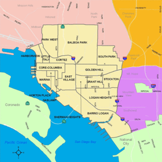
Shelltown is a neighborhood located within Southeast San Diego, approximately 5 minutes from downtown San Diego by car and 25 minutes by bicycle. It is bordered by National City on the south, Interstate 5 and Barrio Logan on the west, 43rd Avenue on the east, and Gamma Court and the neighborhood of Southcrest on the north. Prior to the 1980s the northern border of Shelltown was National Ave and many residents still consider that the northern border.

Southcrest is an urban community in the southeastern section of the city of San Diego. It is bordered by Mountain View on the north and east, Interstate 5 and the neighborhoods of Barrio Logan and Logan Heights on the west, and Shelltown on the south. Major thoroughfares include National Avenue and 40th Street.
Chollas View is an urban community in the southeastern section of the city of San Diego. It is bordered by Webster and California State Route 94 on the north, Mount Hope and Interstate 805 on the west, Emerald Hills and Euclid Avenue on the east, and Lincoln Park and the San Diego Trolley on the south. Major thoroughfares include Market Street and 47th Street.

Lincoln Park is an urban community in the southeastern section of San Diego, California. It is bordered by Chollas View and the San Diego Trolley on the north, Mountain View and Interstate 805 on the west, Valencia Park and Euclid Avenue on the east, and National City, California on the south. Major thoroughfares include Imperial Avenue, Ocean View Boulevard, and Logan Avenue.

Emerald Hills is a community in the southeastern section of the city of San Diego, California, United States. It is bordered by Oak Park and California State Route 94 on the north, Chollas View and Euclid Avenue on the west, Encanto on the east, and Valencia Park and Market Street on the south. Major thoroughfares include Kelton Road and Roswell Street.

Valencia Park is an urban community in the southeastern section of the city of San Diego. It is bordered by Emerald Hills and Market Street on the north, Lincoln Park and Euclid Avenue on the west, Encanto on the east, and Alta Vista and National City, California on the south. Major thoroughfares include Imperial Avenue, Churchward Street, and Valencia Parkway.
Memorial is an urban neighborhood in the southeastern area of San Diego, California. It is generally bounded by Imperial Avenue to the north, California State Route 15 to the east, Interstate 5 to the south, and 28th Street to the west. Major thoroughfares in the neighborhood include Commercial Street, Oceanview Boulevard, and National Avenue. The San Diego Trolley runs through the area. Chollas Creek flows through the eastern edge of the neighborhood.
College Grove Shopping Center, also Marketplace at the Grove, at SR-94 at College Avenue in San Diego on the border of Lemon Grove, is an open-air shopping center, but was originally a regional shopping mall, only the second to be built in San Diego County, and the 37th in the country. It opened July 28, 1960 with an official grand opening ceremony on August 25, 1960. The site had 650,000 sq ft (60,000 m2) of gross leasable space on its 70-acre (28 ha) site. The $28-million center had 60 stores and parking for 6,000 cars on two levels. There was a three-story branch of Walker Scott, the San Diego-based department store. More than 250,000 people attended the first day the center was open. There was a heliport with helicopter service from its heliport to Lindbergh Field airport in San Diego. A new amenity offered was "park-a-tot" child care.