Related Research Articles

Southern California is a geographic and cultural region that generally comprises the southern portion of the U.S. state of California. It includes the Los Angeles metropolitan area, the second most populous urban agglomeration in the United States. The region generally contains ten of California's 58 counties: Imperial, Kern, Los Angeles, Orange, Riverside, San Bernardino, San Diego, Santa Barbara, San Luis Obispo and Ventura counties.

Imperial Beach is a residential beach city in San Diego County, California, with a population of 26,324 at the 2010 census. The city is the southernmost city in California and the West Coast of the United States. It is in the South Bay area of San Diego County, 14.1 miles (22.7 km) south of downtown San Diego and 5 miles (8 km) northwest of downtown Tijuana, Mexico.

North County is a region in the northern area of San Diego County, California. It is the second-most populous region in the county, with an estimated population of 869,322. North County is well known for its affluence, especially in Encinitas, Carlsbad, Del Mar, Rancho Santa Fe, and Solana Beach, where house prices range, on average, above $1,000,000. Cities along the 78 freeway have more mixed incomes.

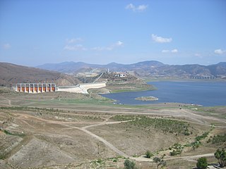
The Salton Sea is a shallow, landlocked, highly saline body of water in Riverside and Imperial counties at the southern end of the U.S. state of California. It lies on the San Andreas Fault within the Salton Trough that stretches to the Gulf of California in Mexico. Over millions of years, the Colorado River has flowed into the Imperial Valley and deposited alluvium (soil), creating fertile farmland, building up the terrain, and constantly moving its main course and river delta. For thousands of years, the river has alternately flowed into the valley, or diverted around it, creating either a saline lake called Lake Cahuilla, or a dry desert basin, respectively. When the Colorado River flows into the valley, the lake level depends on river flows and the balance between inflow and evaporative loss. When the river diverts around the valley, the lake dries completely, as it did around 1580. Hundreds of archaeological sites have been found, indicating possibly long-term Native American villages and temporary camps.
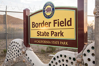
Border Field State Park is a state park of California, United States, containing beach and coastal habitat on the Mexico–United States border. The park is within the city limits of Imperial Beach in San Diego County, next to the suburb of Playas de Tijuana in Mexico. It contains the southernmost point in the state of California. The refuge forms the southern part of the Tijuana River National Estuarine Research Reserve.
The Tijuana River is an intermittent river, 120 mi (195 km) long, near the Pacific coast of northern Baja California state in northwestern Mexico and Southern California in the western United States. The river is heavily polluted with raw sewage from the city of Tijuana, Mexico.
The San Diego and Imperial Valley Railroad (SD&IV) is a class III railroad operating freight rail service in the San Diego area, providing service to customers in the region and moving railcars between the end of the BNSF Railway in Downtown San Diego and the Mexico–United States border in San Ysidro. The railroad has exclusive trackage rights to operates over tracks by the San Diego and Arizona Eastern Railway, a subsidiary of the Metropolitan Transit System, the regional public transit service provider. Tracks are shared with the San Diego Trolley, another subsidiary of the Metropolitan Transit System, and freight trains are only operated at nights when passenger service is not in operation. The San Diego & Imperial Valley Railroad was established in October 1984 and is owned and operated by Genesee & Wyoming, a holding company that operates more than 100 shortline railroads like the SD&IV.

Wildcoast is an international non-profit environmental organization that conserves coastal and marine ecosystems and wildlife.
The New River flows north from near Cerro Prieto, through the city of Mexicali, Baja California, Mexico, into the United States through the city of Calexico, California, towards the Salton Sea. The river channel has existed since pre-historic times. However, the river as known today formed from a levee failure and massive flooding that filled the Salton Sea.

South Bay, also known as South County, is a region in southwestern San Diego County, California consisting of the cities and unincorporated communities of Bonita, Chula Vista, Imperial Beach, Lincoln Acres, National City, and South San Diego.
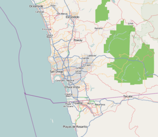
San Diego–Tijuana is an international transborder agglomeration, straddling the border of the adjacent North American coastal cities of San Diego, California, United States and Tijuana, Baja California, Mexico. The 2012 population of the region was 4,922,723, making it the largest bi-national conurbation shared between the United States and Mexico, the second-largest shared between the US and another country. In its entirety, the region consists of San Diego County in the United States and the municipalities of Tijuana, Rosarito Beach, and Tecate in Mexico. It is the third most populous region in the California–Baja California region, smaller only than the metropolitan areas of Greater Los Angeles and the San Francisco Bay Area.

Los Peñasquitos Marsh Natural Preserve and Lagoon is a coastal marsh in San Diego County, California, United States situated at the northern edge of the City of San Diego, forming the natural border with Del Mar, California. This bar-built estuary, previously called The Soledad Lagoon, divides a colony of the endangered Pinus torreyana on a narrow coastal strip. Three streams empty into the lagoon: Carroll Creek, Carmel Creek, Los Peñasquitos Creek with a total drainage basin area of 95 square miles.

Tijuana River National Estuarine Research Reserve is a natural reserve in Imperial Beach, California and San Ysidro, San Diego. It encompasses the Tijuana River Estuary, located on the Mexico–United States border. It is divided into two parts: the Tijuana Slough National Wildlife Refuge on the north, and Border Field State Park in the south.
Palm City is a neighborhood in the southern section of San Diego. It neighbors Otay Mesa West to the south and east, Egger Highlands and Nestor to the west, and Chula Vista to the north. It also serves as a gateway to the beach cities of Imperial Beach, and Coronado, by way of the Silver Strand isthmus, due to it being where California State Route 75 meets Interstate 5. Major thoroughfares include Coronado Avenue, Hollister Street, Beyer Boulevard, and Palm Avenue.

The Tijuana River Estuary is an intertidal coastal wetland at the mouth of the Tijuana River in San Diego County, California, in the United States bordering Tijuana, Baja California, Mexico. It is the location of the Tijuana River National Estuarine Research Reserve, Tijuana Slough National Wildlife Refuge, and Border Field State Park. The estuary is a shallow water habitat. Often termed an intermittent estuary since its volume is subject to the discharge controlled by the seasons of the year, the volume of the estuary fluctuates and at times there is dry land, or flooded areas. It was designated a National Natural Landmark in 1973.
Transportation in San Diego–Tijuana occurs by various means. Though, in the four cities of San Diego, Tijuana, Tecate, and Rosarito Beach, the automobile serves as most important means of transportation. The international metropolitan region maintains an intricate highway infrastructure. As a large metropolitan area in Western North America, many roadways, including Interstates, State Routes, and Mexican Federal Highways, hold a terminus in the area. These roads have grown accustomed to support the masses of the commuting populace within the international region and are constantly being expanded and/or renovated. Transportation is a crucial issue in the metropolitan area. The streets and highways of the region affect environmental health and have influence over the degree of regional connectivity. Binational discussions about coordinating public transportation across the border are currently underway. San Diego–Tijuana is the site of two major international airports and numerous regional airports. It is also the site of the Port of San Diego and miles from the nearby Port of Ensenada.
The International Wastewater Treatment Plant (IWTP) is a plant developed by the International Boundary and Water Commission (IBWC) in the South Bay area of San Diego, California. Construction began on a 75-acre site, west of San Ysidro in the Tijuana River Valley. The project, authorized by the U.S. Congress in 1989 and formally agreed between the two countries in July 1990, was part of a regional approach to solve long-standing problems, particularly the flow of sewage-contaminated water into the ocean via the Tijuana River.
Rancho Melijo, or Milijo, named after a local Kumeyaay village. It was later called Rancho La Punta for the location of the Arguello family ranch house, on a point of hills overlooking the south end of San Diego Bay, north of the Otay River and east of where the river entered the south bend of the bay. It was a Mexican land grant rancho, granted by Governor José Figueroa in 1833 to Santiago E. Argüello.

Goat Canyon also known as Cañón de los Laureles, begins in Tijuana, Mexico, and ends in the United States just north of the Mexico–U.S. border. The canyon is formed by Goat Canyon Creek, which receives water and other runoff from areas south of the border. Most of the canyon and its watershed lies within Baja California.
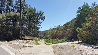
The Smuggler's Gulch is part of a steep walled canyon about 2 miles (3.2 km) inland of the Pacific Ocean. The canyon crosses the Mexico–United States border, between Tijuana, Baja California, and San Diego, California, and Smuggler's Gulch is the part of the canyon on the US side of the border. It may also be called Cañón del Matadero or Valle Montezuma in Spanish, but these names apply more generally to the whole canyon. Smuggling activities within Smuggler's Gulch have occurred since the 19th century, giving this part of the canyon its name.
References
- ↑ Schoenherr, Steven. "The Tijuana River Valley Historic Sites". South Bay Historical Society Bulletin. 9.
- ↑ "Tijuana River Valley | Councilmember Vivian Moreno (District 8) | City of San Diego Official Website".
- ↑ Alvarez, Elizabeth. "Flooding concerns for community in Tijuana River Valley" . Retrieved 2017-11-29.
- 1 2 Tijuana River Valley Recovery Team (January 2012). "Recovery Strategy; Living with the Water" (PDF). Waterboards.ca.gov. Retrieved November 29, 2017.
- ↑ Smith, Sandra Dibble, Joshua Emerson. "Two countries, one sewage problem: Tijuana and San Diego grapple with renegade flows". sandiegouniontribune.com. Retrieved 2017-11-29.
- ↑ Smith, Joshua Emerson. "Tijuana pollution contaminates South Bay beaches at astounding rate". sandiegouniontribune.com. Retrieved 2017-11-29.
 | Tributaries |  | |
|---|---|---|---|
| Waterworks | |||
| Geography | |||
| Protected areas | |||
| Cites, Communities, & Municipalities | |||
| Others | |||