Morena Dam

Last updated
Morena Dam
Morena Reservoir.jpg
View of Morena Reservoir from near the dam, looking upstream, c. 1918
Relief map of California.png
Red pog.svg
Location of Morena Dam in California
CountryUnited States
Location San Diego County, California
Coordinates 32°41′07″N116°32′51″W / 32.68528°N 116.54750°W / 32.68528; -116.54750
PurposeWater supply
Construction began1896;127 years ago (1896)
Opening date1912;111 years ago (1912)
Owner(s) City of San Diego
Dam and spillways
Type of dam Rockfill [1]
ImpoundsCottonwood Creek
Height177 ft (54 m) [1]
Length550 ft (170 m) [1]
Reservoir
CreatesMorena Reservoir
Total capacity50,694 acre⋅ft (62,530,000 m3) [2]
Catchment area 114 sq mi (300 km2) [1]
Surface area1,475 acres (597 ha) [1]
Normal elevation3,039 ft (926 m) (spillway) [3]

Morena Dam is a rockfill dam across Cottonwood Creek, a tributary of the Tijuana River, in southern San Diego County, California in the United States. Originally completed in 1912 and raised several times afterward, the dam is one of the oldest components of the city of San Diego's municipal water system, [2] [4] providing between 1,600 to 15,000 acre-feet (2,000,000 to 18,500,000 m3) of water per year. [3] It is one of the few facilities in the San Diego water supply system that relies entirely on local runoff.

Contents

There is a small lakeside settlement just east of Morena Reservoir called Morena Village. It makes up part of the census-designated place (CDP) of Campo.

Dimensions

Morena Dam is located in the Cleveland National Forest at the headwaters of Cottonwood Creek, about 40 miles (64 km) east of downtown San Diego. The dam is 167 feet (51 m) high from the riverbed and 550 feet (170 m) long, with a height of 177 feet (54 m) from the foundations. [1] Altogether the dam contains 335,300 cubic yards (256,400 m3) of earth and rock fill. [5] At its full height, the reservoir can hold 50,694 acre-feet (62,530,000 m3) of water, covering 1,475 acres (597 ha). [1] The drainage area above the dam is 114 square miles (300 km2) and includes the tributary Morena Creek, for which the dam and reservoir are named.

Water is released via a 387-foot (118 m) long tunnel, fed by an intake tower that can draw up to 595 cubic feet per second (16.8 m3/s) water from different elevations of the reservoir. The spillway is located on the north side of the dam and has a crest 310 feet (94 m) long, topping out at 3,039 feet (926 m) above sea level. Flood flows through the spillway are controlled by steel flash gates 7.5 feet (2.3 m) high. [6] The spillway has a capacity of approximately 25,000 cubic feet per second (710 m3/s). [7]

Usage

Morena Reservoir, also known as Lake Morena, serves primarily for long-term storage of winter flood flows in Cottonwood Creek, and is the uppermost of a chain of three reservoirs – Lower Otay, Barrett and Morena – that provide water to the city of San Diego. Water released from Morena Dam travels several miles down Cottonwood Creek to Barrett Lake, where it is diverted to Lower Otay via the 14-mile (23 km) long Dulzura Conduit. From Lower Otay Reservoir the water enters the Otay Water Treatment Plant, before flowing into the municipal water network. The entire project is known as the Cottonwood-Otay Water System. [3]

Originally providing the city's main water supply, it was relegated to a secondary role after the city began importing water from the Colorado River in 1939. The reservoir now provides a backup water supply that is drawn down during dry years, when stored local water provides a much cheaper alternative than imported water – costing $240 per acre-foot whereas Colorado River water typically costs about $800 per acre-foot. [3] On average, Morena provides only about 3 percent of the city's total supply. [8]

As Morena Reservoir has a larger surface area and thus greater evaporative losses than Barrett Lake, the city generally prioritizes storage in Barrett. Water is moved downstream from Morena as often as possible, if storage space is available in the lower reservoir. [3] In addition, the watershed above Morena generally does not produce enough runoff to fill the reservoir, except in very wet years. Inflows average 10,218 acre-feet (12,604,000 m3) per year, or barely a fifth of the storage capacity. [7] As a result, Morena only reaches spillway level about once per decade. [6]

History

The dam was first proposed in the 1880s by the Southern California Mountain Water Company, which envisioned a system of reservoirs and connecting pipelines to transport water from the Tijuana and Otay river basins to San Diego. [9] A bond issue was approved in 1896 for construction of the Morena Dam, which would form the highest and most remote of the reservoirs. Construction began in fall 1896, directed by San Diego city engineer Edwin Capps. The initial construction was fraught with problems caused by leakage and poor engineering, and work stopped in April 1898. It was not until May 1909 when construction resumed, under engineer Michael O'Shaughnessy. [9] The job was finally finished in 1912, at a cost of about $1.5 million. [10]

The city of San Diego purchased the dam from Mountain Water Company in 1914. Since then, it has been raised several times to increase its capacity – 5 feet (1.5 m) in 1917, 10 feet (3.0 m) in 1923, 4 feet (1.2 m) in 1930 and 2 feet (0.61 m) in 1946. The spillway was rebuilt and widened in 1946 to increase its safety margin in floods. [3]

Because the dam was built in a high mountain area with some of the highest annual rainfall in San Diego County, it was anticipated that its reservoir would fill every year. However, the early 1900s saw continuous drought conditions in Southern California, and the reservoir did not fill to more than a third of its capacity in the first few years of operations. It was not until 1916 (see below) when Morena reached capacity for the first time. [4]

The "Rainmaker"

In 1916, the city of San Diego hired Charles Hatfield, a man known as the "Rainmaker", who had offered to fill Morena Reservoir at a cost of $10,000. Although the city council doubted his ability, Hatfield was hired and set to work "rainmaking" on January 1. By January 10, flooding rains began to fall throughout San Diego County. Rising at a peak rate of two feet (0.6 m) per hour, Morena Reservoir filled and spilled on January 26, a mere 5 inches (13 cm) from the top of the dam. In the rest of the county, flooding washed out bridges, inundated neighborhoods and killed over 50 people. The city subsequently deemed the rains an "act of God" and determined that if Hatfield were to collect the fee for filling Morena reservoir he would also have to pay for the damages caused by the rains. Hatfield never took the money. [11] [12]

Related Research Articles

<span class="mw-page-title-main">Charles Hatfield</span> American cloud seeder (1875–1958)

Charles Mallory Hatfield was an American "rainmaker".

<span class="mw-page-title-main">Castaic Dam</span> Embankment dam impounding Castaic Creek in Los Angeles County, California, United States

Castaic Dam is an embankment dam in northwestern Los Angeles County, California, in the unincorporated area of Castaic. Although located on Castaic Creek, a major tributary of the Santa Clara River, Castaic Creek provides little of its water. The lake is the terminus of the West Branch of the California Aqueduct, part of the State Water Project. The dam was built by the California Department of Water Resources and construction was completed in 1973. The lake has a capacity of 325,000 acre-feet (401,000,000 m3) and stores drinking water for the western portion of the Greater Los Angeles Area.

<span class="mw-page-title-main">El Capitan Reservoir</span> Reservoir in San Diego County, California

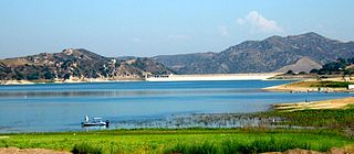
El Capitan Reservoir is a reservoir in central San Diego County, California. It is in the Cuyamaca Mountains, about 30 miles (48 km) northeast of the city of San Diego and two miles northwest of the town of Alpine.

<span class="mw-page-title-main">Monticello Dam</span> Dam in Napa County, California.

Monticello Dam is a 304-foot (93 m) high concrete arch dam in Napa County, California, United States, constructed between 1953 and 1957. The dam impounded Putah Creek to create Lake Berryessa in the Vaca Mountains.

<span class="mw-page-title-main">Navajo Dam</span> Dam in San Juan and Rio Arriba Counties, New Mexico

Navajo Dam is a dam on the San Juan River, a tributary of the Colorado River, in northwestern New Mexico in the United States. The 402-foot (123 m) high earthen dam is situated in the foothills of the San Juan Mountains about 44 miles (71 km) upstream and east of Farmington, New Mexico. It was built by the U.S. Bureau of Reclamation (Reclamation) in the 1960s to provide flood control, irrigation, domestic and industrial water supply, and storage for droughts. A small hydroelectric power plant was added in the 1980s.

<span class="mw-page-title-main">Oologah Lake</span> Reservoir in Oklahoma, United States

Lake Oologah is a reservoir in northeastern Oklahoma. It is located near the towns of Oologah, Nowata, and Claremore. The lake has a surface of 29,500 acres (119 km2) of water and 209 miles (336 km) of shoreline with 11 lake-side parks. The water storage capacity is rated as 552,210 acre-feet (681,140,000 m3). The lake is formed along the Verdigris River, and is a source of water for the Tulsa Metropolitan Area. The purpose of the dam and lake is flood control, water supply, navigation, recreation, and fish and wildlife.

<span class="mw-page-title-main">Lower Otay Reservoir</span> Reservoir in San Diego County, California

Lower Otay Reservoir is a reservoir in San Diego County, Southern California. It is flanked by Otay Mountain to the southeast, the Jamul Mountains to the east, Otay Lakes Road and Upper Otay Reservoir to the north, and the city of Chula Vista to the west.

<span class="mw-page-title-main">Risks to the Glen Canyon Dam</span> Aspect of dam construction

Glen Canyon Dam, a concrete arch dam on the Colorado River in the American state of Arizona, is viewed as carrying a large amount of risk, most notably due to siltation. The Colorado and San Juan rivers deposit large volumes of silt into Lake Powell, slowly decreasing its capacity. The sediment will eventually build up against the dam and could affect its safe operation and lead to its failure.

<span class="mw-page-title-main">New Exchequer Dam</span> Dam in Mariposa County, California

New Exchequer Dam is a concrete–faced, rock-fill dam on the Merced River in central California in the United States. It forms Lake McClure, which impounds the river for irrigation and hydroelectric power production and has a capacity of more than 1,000,000 acre-feet (1.2 km3). The Merced Irrigation District (MID) operates the dam and was also responsible for its construction.

<span class="mw-page-title-main">San Vicente Dam</span> Dam in San Diego County, California.

The 
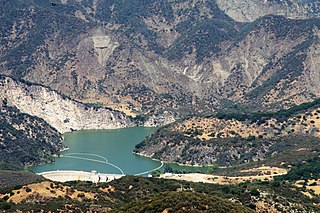
San Vicente Dam is a concrete gravity dam on San Vicente Creek near Lakeside and 25 km (15.5 mi) northeast of San Diego, California. The dam was built between 1941 and 1943 and created San Vicente Reservoir for the purpose of municipal water storage, flood control and recreation. Although the reservoir is fed by run-off, its main source is the First San Diego Aqueduct. In June 2009, construction to raise the height of the dam by 117 ft (36 m), in order to more than double its reservoir size, commenced. It is the largest dam raise in the United States and largest roller-compacted concrete dam raise in the world. The dam raise project was originally set for the end of 2012, but was completed in early 2014. Efforts to replace the water supply pipelines and prepare the reservoir for the public will be underway until 2015–2017.

<span class="mw-page-title-main">Santiago Dam</span> Dam in Orange County, California

Santiago Dam is an earth/rockfill dam across Santiago Creek in Orange County, in the U.S. state of California, forming Irvine Lake. The 136-foot (41 m) earth dam and its reservoir serve for flood control and recreational purposes. It lies upstream (southeast) from the city of Orange and north of Irvine. Irvine Lake is the largest body of fresh water entirely in Orange County.

<span class="mw-page-title-main">Sweetwater Dam</span> Dam in San Diego County, California

The Sweetwater Dam is a dam across the Sweetwater River in San Diego County, California. It is located approximately 12 miles (19 km) east of San Diego, 9 miles (14 km) and borders Bonita to the southwest and La Presa to the northeast. The 108-foot (33 m)-high masonry arch dam impounds 960-acre (390 ha) Sweetwater Reservoir.

<span class="mw-page-title-main">Savage Dam</span> Dam in San Diego County, California

Savage Dam is a dam across the Otay River in the San Ysidro Mountains of southwestern San Diego County, California. It is a concrete arch gravity structure 149 feet (45 m) high, and serves to store water from the San Diego Aqueduct's third pipeline for backup municipal uses in the San Diego metropolitan area. It is just over 6 miles (9.7 km) southeast of Chula Vista and 4 miles (6.4 km) north of the United States-Mexico border. The dam is named in honor of H. N. Savage, who directed its construction.

<span class="mw-page-title-main">Pactola Dam</span> Dam in Pennington County, South Dakota

Pactola Dam is an embankment dam on Rapid Creek in Pennington County, South Dakota, about 10 miles (16 km) west of Rapid City. The dam was completed in 1956 by the U.S. Bureau of Reclamation to provide flood control, water supply and recreation. Along with the nearby Deerfield Dam, it is part of the Rapid Valley Unit of the Pick-Sloan Missouri Basin Program. U.S. Route 385 runs along the crest of the dam. The dam forms Pactola Lake, which at over 1,200 acres (490 ha) is the largest and deepest body of water in the Black Hills.
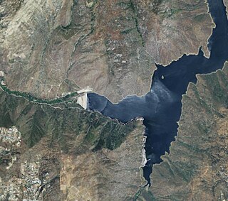
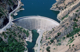
<span class="mw-page-title-main">El Capitan Dam</span> Dam in San Diego County, California

El Capitan Dam is an embankment dam on the San Diego River in southern California. The dam forms the 112,800-acre-foot (139,100,000 m3) El Capitan Reservoir and serves mainly to supply water to the city of San Diego as well as providing flood control. The dam is connected to the San Diego municipal water system via the El Capitan Pipeline, which extends approximately 30 miles (48 km) to the city. It is the second largest storage facility in San Diego's water supply system, after San Vicente Dam.

<span class="mw-page-title-main">Nacimiento Dam</span> Dam in San Luis Obispo County, California

Nacimiento Dam is a dam on the Nacimiento River about 10 miles (16 km) northwest of Paso Robles, California in the United States. The primary purpose of the dam is to provide groundwater recharge for agriculture in Monterey County and northern San Luis Obispo County supported by the Salinas Valley aquifer, as well as flood control, domestic water supply, and hydropower. It forms Lake Nacimiento, popular for boating, fishing and camping, and known locally as the "Dragon Lake" due to its shape.

<span class="mw-page-title-main">Gibraltar Dam</span> Dam in Santa Barbara County, California

Gibraltar Dam is located on the Santa Ynez River, in southeastern Santa Barbara County, California, in the United States. Forming Gibraltar Reservoir, the dam is owned by the city of Santa Barbara. Originally constructed in 1920 and expanded in 1948, the dam and reservoir are located in a remote part of the Los Padres National Forest.

<span class="mw-page-title-main">Heron Dam</span> Dam in Rio Arriba County, New Mexico

Heron Dam is a storage dam Rio Arriba County, in northern New Mexico in the southwestern United States, just north of the El Vado Dam. It is owned and operated by the United States Bureau of Reclamation. The dam is about 9 miles west of the town of Tierra Amarilla.

<span class="mw-page-title-main">Barrett Dam</span> Dam in San Diego County, California

Barrett Dam is a concrete arch-gravity dam in southern San Diego County, California in the United States, forming Barrett Lake on Cottonwood Creek. The dam is part of the city of San Diego's local water supply system.

Cottonwood Creek is a major stream, about 36 miles (58 km) long, in southern San Diego County, California. It is part of the Tijuana River drainage basin.

References

  1. 1 2 3 4 5 6 7 "Morena Dam". National Performance of Dams Program. Stanford University. Archived from the original on 2014-07-14. Retrieved 2014-06-14.
  2. 1 2 "Morena Reservoir". City of San Diego. Retrieved 2014-06-14.
  3. 1 2 3 4 5 6 L. Goehring (4 November 2013). "Morena Reservoir" (PDF). City of San Diego Public Utilities Department. Retrieved 2014-06-15.
  4. 1 2 Hill, Joseph (2002). "Dry Rivers, Dammed Rivers and Floods: An Early History of the Struggle Between Droughts and Floods in San Diego". The Journal of San Diego History. San Diego History Center. 48 (1). Retrieved 2014-06-14.
  5. "Morena Dam (MOR)". California Data Exchange Center. California Department of Water Resources. Retrieved 2014-06-15.
  6. 1 2 Barnes, F.F.; Kraebel, C.J.; Motte, R.S.L. (1939). Effect of Accelerated Erosion on Silting in Morena Reservoir, San Diego County, Calif. U.S. Department of Agriculture. ISSN   0082-9811.
  7. 1 2 V. Chancer (22 March 2011). "DESCRIPTION OF THE SOURCE WATER SYSTEM" (PDF). Retrieved 2014-06-15.
  8. Claire Trageser (21 January 2014). "City, County Politicians Squabbling Over Lake Morena Reservoir | KPBS". kpbs.org. Retrieved 2014-06-15.
  9. 1 2 R. Crawford (30 June 2011). "Building Morena Dam" (PDF). Retrieved 2014-06-15.
  10. United States. Congress. House. Committee on Public Lands (1918). Conservation and storage of water, San Diego, Cal: Hearings before the Committee on the Public Lands, House of Representatives, 2d session on H.R. 4037. a bill to grant rights of way over government lands for reservoir purposes, to be used by the city of San Diego, Cal., and adjacent communities.
  11. "They called Charles Hatfield a commander of nature, the greatest rainmaker of modern times" (PDF). 27 April 2010. Retrieved 2014-06-15.
  12. "Chapter Eleven: The Rainmaker - And Who Caused The Big Flood? | San Diego History Center". sandiegohistory.org. Retrieved 2014-06-15.