Playas de Tijuana

Last updated
Playas de Tijuana
Delegación Municipal Playas de Tijuana
Municipal Borough Playas de Tijuana
Playas de Tijuana.jpg
View of the beaches
Nickname: 
Playas OT beach
Location map Tijuana.png
Red pog.svg
Playas de Tijuana
Location within Tijuana
Coordinates: 32°31′22″N117°06′45″W / 32.522717°N 117.112428°W / 32.522717; -117.112428
State Flag of Baja California.svg Baja California
Municipality Tijuana
Borough Delegación Playas de Tijuana
Government
  TypeDelegación
  Municipal DelegateManuel González Reyes
  Secretary GeneralJosé Esteban Hernández Cuevas
Population
 (2015)
   Borough of Tijuana 146,021
   Urban
160,301
   Metro
159,866
Website(in Spanish) Playas de Tijuana

Playas de Tijuana (Spanish for "beaches of Tijuana") is the westernmost borough of the municipality of Tijuana, Baja California, stretching from the United States border in the north to Rosarito Beach Municipality in the south. The Bullring by the Sea was opened in 1960.

Contents

History

The current border between Baja California in Mexico and California in the United States was delineated in 1848. A marble monument was erected on the border near the shoreline in 1851.

The borough began to be developed in 1957 with the fraccionamientos of Soler and Costa Azul. The name "Playas de Tijuana" was acquired in 1959. The Bullring by the Sea was opened in 1960. Development continued through the 1980s.

Geography

The borough of Playas de Tijuana is located in the city of Tijuana, bordered by the Pacific Ocean to the west, the United States ( California ) to the north, the municipality of Playas de Rosarito to the south and the boroughs Centro to the Northeast and San Antonio de los Buenos to the East.

Playas de Tijuana borders the United States cities of Imperial Beach and San Diego, but there is no border crossing in the borough. In contrast to Playas de Tijuana, the Tijuana River Valley immediately north of the border remains rural and agricultural in character.

Administration

View of the U.S.-Mexico border fence from Playas de Tijuana, at the left. Before fortification Borderbeachtj.jpg
View of the U.S.-Mexico border fence from Playas de Tijuana, at the left. Before fortification

Its administration or government relies on a Municipal Delegate, or Delegado Municipal(in Spanish), who is appointed by the Municipal President of Tijuana.

Borough Service Departments

The borough is in charge of the following services:

Entertainment and culture

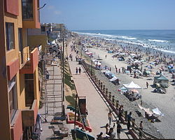
The Paseo Ensenada is a popular place for meeting and passing free time, and where major commercial centres and businesses are located. Plaza Coronado, which is located at the beginning of Paseo Ensenada, is the major entertainment centre, where mainly young people gather every day to spend free time. Water sports such as surfing, bodyboarding, and kayaking are available when ocean water quality is good—the water quality can be very bad soon after it rains. The Monumental bullring [1] is located here as well as the Tijuana campus of the Universidad Iberoamericana. [2]

Kids playing at sunset in Playas de Tijuana Sunset Playas de Tijuana.jpg
Kids playing at sunset in Playas de Tijuana

Playas de Tijuana has its own Arts & Culture House, which has many local and artistic endeavors, such as a ballet school, a drawing school, painting school, dancing school, and many others. The Arts & Culture House is located inside the complex where the local government building is, and also inside the complex there is another smaller bullfight ring, known as the Cortijo San José, which sometimes hosts rodeo shows. Along with the administration buildings, the House, and the Cortijo, there is a civic square where every September 15 is held the independence celebration. Playas de Tijuana is home to several NGO's that are leaders in local issues like sustainable development, clean water quality in local beaches and public policy like open space and parkland protection and against a number of housing developments that prevent free access to local beaches and urban sprawl and violence. Federal Highway 1-D starts just south of this borough towards Rosarito and Ensenada.

Cityscape

Park Towers Tower I and Tower II under construction Park Towers Playas.jpg
Park Towers Tower I and Tower II under construction
TRW building in Playas TRW Playas.jpg
TRW building in Playas

Playas de Tijuana has a good offering of hotels, residences, and places to live, either temporarily or permanently. Such places include the following:

Playas has been recently experiencing mid/high-rise building growth despite opposition from environmental organizations and local laws. One project is the 17-story high Park Towers complex, with four towers projected. Many other low-rise buildings, ranging from 5+ story are found throughout Playas. However, the economic downturn beginning in 2008 has caused many half-finished projects to be abandoned.

Transportation

Playas, as it is the westernmost and thus the last portion in Tijuana, is linked to the rest of the city by two Azul y Blanco bus routes:

Playas is also linked to the rest of the city served by three fixed-route taxi lines:

Related Research Articles

<span class="mw-page-title-main">Tijuana</span> City in Baja California, Mexico

Tijuana is the largest city in the state of Baja California located on the northwestern Pacific Coast of Mexico. Tijuana is the municipal seat of the Tijuana Municipality and the hub of the Tijuana metropolitan area. It has a close proximity to the Mexico–United States border, which is part of the San Diego-Tijuana metro area.

<span class="mw-page-title-main">Rosarito</span> City in Baja California, Mexico

Rosarito is a coastal city in Playas de Rosarito Municipality, Baja California, on the Pacific Coast of Mexico. As of 2010, the city had a population of 65,278. Located 10 miles (16 km) south of the US-Mexico border, Rosarito is a part of the greater San Diego–Tijuana region and one of the westernmost cities in Mexico. Rosarito is a major tourist destination, known for its beaches, resorts, and events like Baja Beach Fest.

<span class="mw-page-title-main">Ensenada Municipality</span> Municipality in the Mexican state of Baja California

The municipality of Ensenada is the fourth-largest municipality in Mexico with a land area of 19,526.8 km2 (7,539.3 sq mi) in 2020, about the same size as Hidalgo state and larger than five Mexican states.

<span class="mw-page-title-main">Mexican Federal Highway 1</span> Highway in Mexico

Federal Highway 1 is a free (libre) part of the federal highway corridors of Mexico, and the highway follows the length of the Baja California Peninsula from Tijuana, Baja California, in the north to Cabo San Lucas, Baja California Sur, in the south. The road connects with Via Rapida, which merges into the American Interstate 5 (I-5) at the San Ysidro Port of Entry, which crosses the international border south of San Ysidro, California.

<span class="mw-page-title-main">Tijuana Municipality</span> Municipality in the Mexican state of Baja California

Tijuana Municipality is a municipality in the Mexican state of Baja California. Its municipal seat is located in the city of Tijuana. According to the 2020 census, the municipality had a population of 1,922,523. Montserrat Caballero of the MORENA is the current mayor. The municipality comprises the largest part of the Tijuana metropolitan area.

<span class="mw-page-title-main">Playas de Rosarito Municipality</span> Municipality in the Mexican state of Baja California

Playas de Rosarito Municipality is located in the northwestern part of the Mexican state of Baja California comprising part of the Tijuana metropolitan area. It lies just south of the city of Tijuana. Its municipal seat is the city of Rosarito. According to the 2020 census, the municipality had a population of 126,890 inhabitants. Its area is 513.32 km².

<span class="mw-page-title-main">XESDD-AM</span> Radio station in Tijuana, Baja California, Mexico

XESDD-AM or La Tremenda is a radio station in Tijuana, Baja California, Mexico. It broadcasts on 1030 kHz from a site along Mexican Federal Highway 1 near Puerto Nuevo in Playas de Rosarito Municipality, shared with sister station XESS-AM 620.

<span class="mw-page-title-main">Metropolitan areas of Mexico</span> List of biggest metropolitan areas in Mexico

Metropolitan areas of Mexico have been traditionally defined as the group of municipalities that heavily interact with each other, usually around a core city, in Mexico. The phenomenon of metropolization in Mexico is relatively recent, starting in the 1940s. Because of an accelerated level of urbanization in the country, the definition of a metropolitan area is reviewed periodically by the Mexican population and census authorities.

<span class="mw-page-title-main">San Diego–Tijuana</span> Transborder agglomeration of the Californias

<span class="mw-page-title-main">Zona Río</span> Neighborhood of Tijuana in Baja California, Mexico

Zona Río is an official zone, and the main modern business district, of the city of Tijuana, Mexico.

Federal Highway 1D is a tolled part of the Mexico Federal Highways, paralleling Fed. 1. There are two segments, one in the state of Baja California and another in the state of Baja California Sur.

Mexicoach is a private transportation operator that provides cross-border service in the San Diego–Tijuana metropolitan area. The company has been in existence since 1970, with the main purpose of allowing day trippers to avoid the one-mile walk between customs and the Avenida Revolución. In recent years, the service's draw has been to avoid the long lines at the port of entry, which have plagued both vehicular and foot travellers, because Mexicoach passes between the two nations in a special clearance lane.

<span class="mw-page-title-main">Hotel Riviera del Pacífico</span> Historic hotel in Ensenada, Baja California

The Hotel Riviera del Pacífico was a hotel located in Ensenada, Baja California, Mexico. It was one of the most prestigious and luxurious hotels in Mexico.

Transportation in San Diego–Tijuana occurs by various means. Though, in the four cities of San Diego, Tijuana, Tecate, and Rosarito Beach, the automobile serves as most important means of transportation. The international metropolitan region maintains an intricate highway infrastructure. As a large metropolitan area in Western North America, many roadways, including Interstates, State Routes, and Mexican Federal Highways, hold a terminus in the area. These roads have grown accustomed to support the masses of the commuting populace within the international region and are constantly being expanded and/or renovated. Transportation is a crucial issue in the metropolitan area. The streets and highways of the region affect environmental health and have influence over the degree of regional connectivity. Binational discussions about coordinating public transportation across the border are currently underway. San Diego–Tijuana is the site of two major international airports and numerous regional airports. It is also the site of the Port of San Diego and miles from the nearby Port of Ensenada.

Corredor Tijuana-Rosarito 2000, also Bulevar 2000, Boulevard 2000, Corredor 2000, is a freeway in northwestern Baja California connecting the Mesa de Otay area of eastern Tijuana with Rosarito Beach. 42 kilometres (26 mi) long, it runs along the southeastern edge of the developed area of metropolitan Tijuana and is considered a major infrastructure project in the state. The freeway was designed for traffic of 75,000 cars per day and to spur development of a half-million new residential units.

<span class="mw-page-title-main">Complejo Recreativo y Cultural La Guancha</span> Recreational complex in Ponce, Puerto Rico

The Complejo Recreativo y Cultural La Guancha is a recreational complex in barrio Playa in Ponce, Puerto Rico, with family recreational and cultural facilities that opened on 23 June 1998. The highlight of the complex is the Paseo Tablado La Guancha, which is flanked by a beach, an observation tower, an amphitheater, and 24 open-air kiosks. It was developed during the administration of Mayor Rafael Cordero Santiago. In October 2017, after Hurricane Maria, it closed to the public to undergo repairs but, as of January 2020, when the area suffered severe damage due to the 2020 Puerto Rico earthquakes, no repairs had been made and, as of 17 June 2020, it remained closed. By late 2020 arrangements were made for the merchants that operated from waterfront kiosks to reopen their businesses out of provisional facilities at a temporary location away from the waterfront while reconstruction of the waterfront area takes place.

References