Rancho San Diego, California

Last updated

Rancho San Diego
San Diego County California Incorporated and Unincorporated areas Rancho San Diego Highlighted.svg
Location in San Diego County and the state of California
Usa edcp location map.svg
Red pog.svg
Rancho San Diego
Location in the United States
Coordinates: 32°45′58″N116°55′17″W / 32.76611°N 116.92139°W / 32.76611; -116.92139
Country Flag of the United States.svg  United States
State Flag of California.svg  California
County San Diego
County service area established1970 [1]
Area
[2]
  Total8.701 sq mi (22.536 km2)
  Land8.701 sq mi (22.536 km2)
  Water0 sq mi (0 km2)  0%
Elevation
[3]
361 ft (110 m)
Population
  Total21,858
  Density2,500/sq mi (970/km2)
Time zone UTC-8 (Pacific)
  Summer (DST) UTC-7 (PDT)
ZIP codes
91941, 91978, 92019
Area code 619
FIPS code 06-59550
GNIS feature ID 1867053

Rancho San Diego is a census-designated place (CDP) in the East County region of San Diego County, California. The population was 21,858 at the 2020 census, up from 21,208 at the 2010 census. The area was developed as subdivisions beginning in the 1970s. [4]

Contents

Geography

Rancho San Diego is located at 32°45′58″N116°55′17″W / 32.76611°N 116.92139°W / 32.76611; -116.92139 (32.765985, -116.921477). [5] According to the United States Census Bureau, the CDP has a total area of 8.7 square miles (23 km2), all land. The chance of earthquake damage in Rancho San Diego is much lower than California average and is much higher than the national average. The risk of tornado damage in Rancho San Diego is about the same as California average and is much lower than the national average. The average temperature of Rancho San Diego is 64.73 °F.

Climate

According to the Köppen Climate Classification system, Rancho San Diego has a warm-summer Mediterranean climate, abbreviated "Csa" on climate maps. [6]

Demographics

The residents of Rancho San Diego are upper-middle-income, making it an above-average-income community. Rancho San Diego has a higher income than 64.4% of the neighborhoods in America. 28.7% of its working population is employed in executive, management, and professional occupations. The most common language spoken in Rancho San Diego is English, spoken by 72.2% of households. Other important languages spoken here include Arabic, Aramaic, and Spanish.[ citation needed ]

2010

The census reported that 21,164 people (99.8% of the population) lived in households, 44 (0.2%) lived in non-institutionalized group quarters, and no one was institutionalized.

There were 7,830 households, 2,659 (34.0%) had children under the age of 18 living in them, 4,605 (58.8%) were opposite-sex married couples living together, 834 (10.7%) had a female householder with no husband present, 330 (4.2%) had a male householder with no wife present. There were 311 (4.0%) unmarried opposite-sex partnerships, and 62 (0.8%) same-sex married couples or partnerships. 1,653 households (21.1%) were one person and 713 (9.1%) had someone living alone who was 65 or older. The average household size was 2.70. There were 5,769 families (73.7% of households); the average family size was 3.16.

The age distribution was 4,681 people (22.1%) under the age of 18, 2,124 people (10.0%) aged 18 to 24, 4,867 people (22.9%) aged 25 to 44, 6,688 people (31.5%) aged 45 to 64, and 2,848 people (13.4%) who were 65 or older. The median age was 41.2 years. For every 100 females, there were 94.1 males. For every 100 females age 18 and over, there were 91.3 males.

There were 8,152 housing units at an average density of 936.9 per square mile, of the occupied units 5,580 (71.3%) were owner-occupied and 2,250 (28.7%) were rented. The homeowner vacancy rate was 0.8%; the rental vacancy rate was 6.5%. 15,530 people (73.2% of the population) lived in owner-occupied housing units and 5,634 people (26.6%) lived in rental housing units.

Historical population
CensusPop.Note
2000 20,155
2010 21,2085.2%
2020 21,8583.1%
U.S. Decennial Census [7]

Estimated median household income in 2011: $83,458 (it was $68,185 in 2000). Mean prices in 2011: All housing units: $620,385; Detached houses: $699,869; Townhouses or other attached units: $348,104; In 2-unit structures: $299,548; In 3-to-4-unit structures: $275,297; In 5-or-more-unit structures: $277,349; Mobile homes: $93,180 Median household income for houses/condos with a mortgage: $107,787 Median household income for apartments without a mortgage: $69,528 Median gross rent in 2011: $1,614.

2000

At the 2000 census there were 20,155 people, 7,083 households, and 5,588 families in the CDP. The population density was 2,271.7 inhabitants per square mile (877.1 inhabitants/km2). There were 7,231 housing units at an average density of 815.0 per square mile (314.7/km2). The racial makeup of the CDP was 66.7% White, 3.3% African American, 0.6% Native American, 4.2% Asian, 0.3% Pacific Islander, 14.3% from other races, and 4.83% from two or more races. Hispanic or Latino of any race were 10.8%. [8]

Of the 7,083 households 40.8% had children under the age of 18 living with them, 64.9% were married couples living together, 10.4% had a female householder with no husband present, and 21.1% were non-families. 15.8% of households were one person and 3.8% were one person aged 65 or older. The average household size was 2.84 and the average family size was 3.19.

The age distribution was 27.3% under the age of 18, 8.7% from 18 to 24, 29.3% from 25 to 44, 26.4% from 45 to 64, and 8.3% 65 or older. The median age was 37 years. For every 100 females, there were 95.9 males. For every 100 females age 18 and over, there were 92.8 males.

The median household income was $68,185 and the median family income was $75,919 (these figures had risen to $91,821 and $101,426 respectively as of a 2007 estimate [9] ). Males had a median income of $48,995 versus $36,093 for females. The per capita income for the CDP was $29,834. About 3.6% of families and 4.6% of the population were below the poverty line, including 5.5% of those under age 18 and 5.1% of those age 65 or over.

Government

In the California State Legislature, Rancho San Diego is in the 38th Senate District , represented by Democrat Catherine Blakespear, and in the 71st Assembly District , represented by Republican Kate Sanchez. [10]

In the United States House of Representatives, Rancho San Diego is in California's 50th congressional district , represented by Democrat Scott Peters. [11]

County Service Area No. 26 (Rancho San Diego) provides landscape and open-space maintenance. [1]

Schools

Rancho San Diego is served by the Cajon Valley Union School District and the Grossmont Union High School District.

Steele Canyon High School and Valhalla High School are the primary high schools in this location.

Rancho San Diego is also home to Cuyamaca College, as well as Kumeyaay Community College.

Related Research Articles

<span class="mw-page-title-main">San Lorenzo, California</span> Unincorporated community in California, United States

San Lorenzo is a census-designated place (CDP) located in the East Bay of the San Francisco Bay Area in Alameda County, California, United States. The population was 29,581 at the 2020 census. It is an unincorporated community, located at the banks of San Lorenzo Creek. It was originally named Squattersville in 1851, but later renamed to San Lorenzo.

<span class="mw-page-title-main">Rodeo, California</span> Census-designated place in California, United States

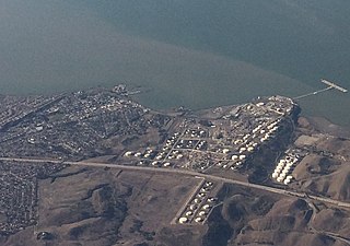
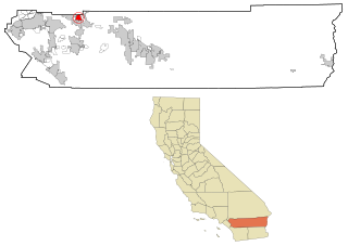
Rodeo is a census-designated place (CDP) located in Contra Costa County, California, in the East Bay sub-region of the San Francisco Bay Area, on the eastern shore of San Pablo Bay, 25 miles northeast of San Francisco. The population was 9,653 at the 2020 census. The town is named for the rodeos common in the late 19th century. Cattle from the surrounding hills were regularly driven down through the old town to a loading dock on the shoreline of San Pablo Bay for shipment to slaughterhouses, a practice which continued through the early 20th century. The town of Rodeo is served by the Interstate 80 freeway and State Route 4. The Southern Pacific Railroad main line passes through Rodeo. Rodeo has not been a stop on the railroad since the 1950s.

<span class="mw-page-title-main">East Rancho Dominguez, California</span> Unincorporated community in California, United States

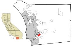
East Rancho Dominguez, also known as East Compton, is an unincorporated community and census-designated place (CDP) located in southern Los Angeles County, California. The population was 15,135 at the 2010 census, up from 9,286 at the 2000 census. East Rancho Dominguez is an accepted city name according to the USPS, and shares the 90221 ZIP Code with Compton.

<span class="mw-page-title-main">West Rancho Dominguez, California</span> Unincorporated community in California, United States

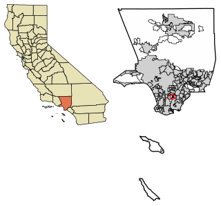
West Rancho Dominguez, formerly known as West Compton, is an unincorporated census-designated place (CDP) located in southern Los Angeles County, California. Per the 2020 census, the population was 24,347. The community lies to the west of the city of Compton. The ZIP Codes encompassing the CDP area are 90220 & 90248.

<span class="mw-page-title-main">West Whittier-Los Nietos, California</span> Census-designated place in California, United States

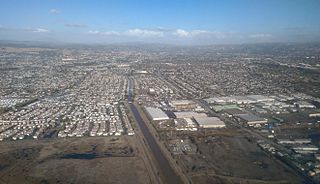
West Whittier-Los Nietos is a census-designated place (CDP) in Los Angeles County, California, near the San Gabriel River and the San Gabriel River (I-605) Freeway. The population was 25,540 at the 2010 census, up from 25,129 at the 2000 census. The census area consists of separate unincorporated communities of Los Nietos and West Whittier.

<span class="mw-page-title-main">San Ardo, California</span> Unincorporated community in California, United States

San Ardo, formerly known as San Bernardo, is an unincorporated community and census-designated place (CDP) in Monterey County, California, United States. San Ardo is located 18 miles (29 km) southeast of King City at an elevation of 449 feet (137 m). The population was 392 at the 2020 census, down from 517 in 2010.

<span class="mw-page-title-main">Angwin, California</span> Census-designated place in California, United States

Angwin is a census-designated place (CDP) in Napa County, California, best known as the site of Pacific Union College. It is part of the northern San Francisco Bay Area. The population was 3,051 at the 2010 census. Its area code is 707. Its two zip codes are 94508 and 94576. It is in the Pacific time zone.

<span class="mw-page-title-main">Las Flores, California</span> Census-designated place in California, United States

Las Flores is an unincorporated census-designated place (CDP) in Orange County, California, located adjacent to the City of Rancho Santa Margarita, California. The population was 5,971 at the 2010 census, up from 5,625 at the 2000 census. Las Flores does not have its own ZIP Code and is served by the same ZIP Code as adjacent Rancho Santa Margarita. The Rancho Santa Margarita dog/skate park is located in the CDP and is served by the Orange County Sheriff's Dept. and Orange County Fire Authority.

<span class="mw-page-title-main">Cherry Valley, California</span> Census-designated place in California, United States

Cherry Valley is a census-designated place (CDP) in Riverside County, California, United States. The population was 6,362 at the 2010 census, up from 5,891 at the 2000 census. It is situated at the most northwestern point of the San Gorgonio Pass.

<span class="mw-page-title-main">Gold River, California</span> Census-designated place in California, United States

Gold River is a census-designated place (CDP) in Sacramento County, California. The population was 7,812 at the 2010 census, down from 8,023 at the 2000 census. Gold River is part of the Sacramento–Arden-Arcade–Roseville Metropolitan Statistical Area. With a median family income of $141,399 according to U.S Census Bureau in 2021, Gold River is the highest-income place in Sacramento County.

<span class="mw-page-title-main">Rancho Murieta, California</span> Census-designated place in California, United States

Rancho Murieta is a census-designated place (CDP) and guard-gated community in Sacramento County, California, United States. It is part of the Sacramento–Arden-Arcade–Roseville Metropolitan Statistical Area. The population was 5,488 at the 2010 census, up from 4,193 at the 2000 census. It is located in the foothills of the Sierra Nevada range, about 25 miles (40 km) east of Sacramento.

<span class="mw-page-title-main">Crest, California</span> Census-designated place in California, United States

Crest is an unincorporated community in the East County region of San Diego County, California. The Crest census-designated place (CDP) had a population of 2,828 at the 2020 census, down from 2,593 at the 2010 census.

<span class="mw-page-title-main">Fairbanks Ranch, California</span> Census-designated place in California, United States

Fairbanks Ranch is a census-designated place (CDP) in San Diego County, California. The population was 3,148 at the 2010 census, up from 2,244 at the 2000 census. The entire population is contained within two gated communities, divided into North and South sections by the formerly private San Dieguito Road.

<span class="mw-page-title-main">Granite Hills, California</span> Census-designated place in California, United States

Granite Hills is a census-designated place in San Diego County, California. The name is also applied to a neighborhood within the city limits of El Cajon in the eastern part of that city. The population of the CDP, which does not include the people living within the city of El Cajon, was 3,035 at the 2010 census, down from 3,246 at the 2000 census.

<span class="mw-page-title-main">Lake San Marcos, California</span> Census-designated place in California, United States

Lake San Marcos is a census-designated place (CDP) in the North County region of the San Diego metropolitan area. It is nominally independent of San Marcos proper, but functionally subservient to the city.

<span class="mw-page-title-main">Rainbow, California</span> Census designated place in California, United States

Rainbow is a census designated place (CDP) in northern San Diego County in the U.S. state of California. The population was 1,832 at the 2010 census, down from 2,026 at the 2000 census.

<span class="mw-page-title-main">Ramona, San Diego County, California</span> Census designated place in California, United States

Ramona is a census-designated place (CDP) in San Diego County, California. The population was 20,292 at the 2010 census.

<span class="mw-page-title-main">Rancho Santa Fe, California</span> Census-designated place in California, United States

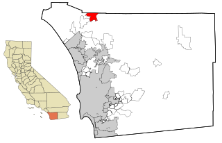
Rancho Santa Fe is a census-designated place (CDP) in San Diego County, California, United States, within the San Diego metropolitan area. The population was 3,156 at the 2020 census. The CDP is primarily residential with a few shopping blocks, a middle and elementary school, and several restaurants.

<span class="mw-page-title-main">Fetters Hot Springs-Agua Caliente, California</span> Census-designated place in California, United States

Fetters Hot Springs-Agua Caliente is a census-designated place (CDP) in Sonoma Valley, Sonoma County, California, in the United States. As of the 2010 census, the CDP population was 4,144. The name Agua Caliente translates into English, from Spanish, as hot water, referring to the hot springs historically found in the area.

<span class="mw-page-title-main">Rancho Calaveras, California</span> Census-designated place in California, United States

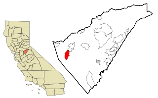
Rancho Calaveras is a census-designated place (CDP) in Calaveras County, California, United States. The population was 5,325 at the 2010 census, up from 4,182 at the 2000 census.

References

  1. 1 2 Directory of Special Districts in San Diego County (PDF). San Diego Local Agency Formation Commission. 2011. Archived from the original (PDF) on January 16, 2016. Retrieved April 9, 2015.
  2. "2010 Census U.S. Gazetteer Files – Places – California". United States Census Bureau.
  3. "Rancho San Diego". Geographic Names Information System . United States Geological Survey, United States Department of the Interior . Retrieved April 10, 2015.
  4. Rancho San Diego Specific Plan (PDF). North Island Credit Union. 2013. Archived (PDF) from the original on April 13, 2015.
  5. "US Gazetteer files: 2010, 2000, and 1990". United States Census Bureau. February 12, 2011. Retrieved April 23, 2011.
  6. "Rancho San Diego, California Köppen Climate Classification (Weatherbase)". Weatherbase. Retrieved April 20, 2018.
  7. "Census of Population and Housing". Census.gov. Retrieved October 31, 2021.
  8. "U.S. Census website". United States Census Bureau . Retrieved January 31, 2008.
  9. Bureau, U.S. Census. "American FactFinder - Community Facts". factfinder.census.gov. Archived from the original on February 11, 2020. Retrieved April 20, 2018.
  10. "Statewide Database". UC Regents. Archived from the original on February 1, 2015. Retrieved December 8, 2014.
  11. "California's 50th Congressional District - Representatives & District Map". Civic Impulse, LLC.