Related Research Articles

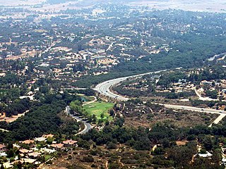
San Jacinto is a city in Riverside County, California, United States. It is located at the north end of the San Jacinto Valley, with Hemet to its south and Beaumont, California, to its north. The mountains associated with the valley are the San Jacinto Mountains. The population was 44,199 at the 2010 census. The city was founded in 1870 and incorporated on April 20, 1888, making it one of the oldest cities in Riverside County.

Julian is a census-designated place (CDP) in San Diego County, California. As of the 2020 census, the population was 1,768, up from 1,502 at the time of the 2010 census.

Pine Valley is a community and census-designated place (CDP) in the Cuyamaca Mountains of the Mountain Empire area, in southeastern San Diego County, California. The population was 1,510 at the 2010 census, up from 1,501 at the 2000 census.
Ramona is a census-designated place (CDP) in San Diego County, California. The population was 20,292 at the 2010 census.
Cuyamaca is a region of eastern San Diego County. It lies east of the Capitan Grande Indian Reservation in the western Laguna Mountains, north of Descanso and south of Julian. Named for the 1845 Rancho Cuyamaca Mexican land grant, the region is now dominated by the 26,000-acre (110 km2) Cuyamaca Rancho State Park. Within the park is the prominent Cuyamaca Peak, the second-highest mountain in San Diego County at 6,512 feet (1,984.9 m).

Campo is an unincorporated community in the Mountain Empire area of southeastern San Diego County, California, United States. The population was 2,955 at the 2020 United States census, up from 2,684 at the 2010 census. For statistical purposes, the United States Census Bureau has defined Campo as a census-designated place (CDP). The census definition of the area may not precisely correspond to local understanding of the area with the same name.

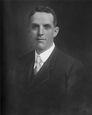
George White Marston was an American politician, department store owner, and philanthropist. Marston was involved with establishing Balboa Park, the San Diego Public Library System, and San Diego Presidio Park. His contributions to San Diego earned him the affectionate title of "San Diego's First Citizen."
"Colonel" Ed Fletcher was a real estate developer and U.S. Republican and Democratic politician from San Diego, California.
Olive is an unincorporated parcel of about 32.67 acres (132,200 m2) in the city of Orange, located along Lincoln Avenue, between Eisenhower Park and Orange Olive Road.

Clairemont is a community within the city of San Diego, California, United States. It has a population of about 81,600 residents and an area of roughly 13.3 square miles (34 km2). Clairemont Mesa is bordered by Interstate 805 on the east, Interstate 5 to the west, State Route 52 to the north, and the community of Linda Vista to the south. The community of Clairemont Mesa can be subdivided into the neighborhoods of North Clairemont, Clairemont Mesa East, Clairemont Mesa West, Bay Park, and Bay Ho.

The Cuyamaca Mountains, locally the Cuyamacas, are a mountain range of the Peninsular Ranges System, in San Diego County, southern California. The mountain range runs roughly northwest to southeast. The Laguna Mountains are directly adjacent to the east, with Palomar Mountain and Hot Springs Mountain more distant to the north.
Banner is an unincorporated community in San Diego County, California. It lies at an elevation of 2743 feet. It is located on California State Route 78.

San Diego County, officially the County of San Diego, is a county in the southwestern corner of the U.S. state of California. As of the 2020 census, the population was 3,298,634, making it California's second-most populous county and the fifth-most populous in the United States. Its county seat is San Diego, the second-most populous city in California and the eighth-most populous city in the United States. It is the southwesternmost county in the 48 contiguous United States, and is a border county. It is also home to 18 Native American tribal reservations, the most of any county in the United States.
The Twenty-Nine Palms Band of Mission Indians of California is a federally recognized tribe of Mission Indians with a reservation consisting of two sections, one located near the cities of Indio and Coachella in Riverside County, and the other in the city of Twentynine Palms in San Bernardino County, California. While many scholars regard the tribe as being Luiseño, the tribe itself identifies as being Chemehuevi.

The Inaja Band of Diegueño Mission Indians of the Inaja and Cosmit Reservation is a federally recognized tribe of Kumeyaay Indians, who are sometimes known as Mission Indians.
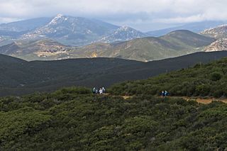
The Mountain Empire is a rural area in southeastern San Diego County, California. The Mountain Empire subregion consists of the backcountry communities in southeastern San Diego County. The area is also sometimes considered part of the East County region of San Diego County.
Earthquake Valley is a desert valley east of Julian, California, which contains parts of the Anza-Borrego Desert State Park. It is the location of the Shelter Valley Ranchos subdivision, which is also known as the unincorporated community of Shelter Valley. The official USGS place name for the geologic feature in which Shelter Valley is situated is "Earthquake Valley", and the 1959 USGS Topographic map makes no reference to Shelter Valley. The name of the unincorporated community Shelter Valley is typically used both locally and by the media to refer generally to the geological feature of Earthquake Valley, and it is common for both names to be referenced in publications after the 1962 establishment of the subdivision. Author, poet, artist and primitivist Marshal South lived in and wrote about the general area, in a series of articles for Desert Magazine between 1941 and 1948. A number of notable trails pass through the valley, including the Pacific Crest Trail, the California Riding and Hiking Trail, and the Southern Emigrant Trail.
Branson City or Branson is a ghost town in San Diego County, California. It lies at an elevation of 3996 feet. It is located on State Highway 78 at its junction with Pine Hills Road, about one mile west of Julian.
Kentwood-In-The-Pines is an unincorporated community, 0.8 miles (1.3 km) east-southeast of Julian in San Diego County, California.
Eastwood is a ghost town in San Diego County, California. It was located a mile northwest of Julian, near Eastwood Creek.
References
- ↑ "Pine Hills". Geographic Names Information System . United States Geological Survey, United States Department of the Interior.
- ↑ "Pine Hill | Trademark Venues".
- ↑ "Camps | YMCA of San Diego County".
- ↑ "PINE HILLS MUTUAL WATER COMPANY | Julian, CA 92036". www.pinehillswater.org.
- ↑ Bevil, Alexander D. (February 28, 2014). "CUYAMACA RANCHO STATE PARK HISTORIC BACKGROUND STUDY & HISTORIC INVENTORY" (PDF). California State Parks - CA.gov.
- ↑ "pine hills community association". Pine Hills Community Association.
- ↑ Frickstad, Walter N., A Century of California Post Offices 1848-1954, Philatelic Research Society, Oakland, CA. 1955, pp. 147-158.
