Casa de Oro-Mount Helix, California

Last updated

Casa de Oro-Mount Helix
San Diego County California Incorporated and Unincorporated areas Casa de Oro-Mount Helix Highlighted.svg
Location in San Diego County and the state of California
Usa edcp location map.svg
Red pog.svg
Casa de Oro-Mount Helix
Location in the United States
Coordinates: 32°45′48″N116°58′39″W / 32.76333°N 116.97750°W / 32.76333; -116.97750
Country Flag of the United States.svg  United States
State Flag of California.svg  California
County Flag of San Diego County, California.png San Diego
Area
[1]
  Total6.85 sq mi (17.74 km2)
  Land6.85 sq mi (17.74 km2)
  Water0.00 sq mi (0.00 km2)  0%
Population
  Total19,576
  Density2,857.39/sq mi (1,103.25/km2)
Time zone UTC-8 (Pacific)
  Summer (DST) UTC-7 (PDT)
ZIP codes
91941, 91977, 92020
Area code 619
FIPS code 06-11691
GNIS feature ID 2407979

Casa de Oro-Mount Helix is a census-designated place (CDP) in the East County region of San Diego County, California.

Contents

The CDP encompasses several unincorporated neighborhoods near the cities of El Cajon and La Mesa and the CDP of Spring Valley. Locations in the northern (Mount Helix) part of the CDP use La Mesa addresses, while locations in the southern (Casa de Oro) part use Spring Valley addresses. Informally, Casa de Oro is often considered to be a part of Spring Valley.

The population was 18,762 at the 2010 census, down from 18,874 at the 2000 census.[ citation needed ]

History

Mount Helix behind the steeple of Santa Sophia Church (inaugurated 1958) Casa-de-Oro-Mount-Helix California Jason Kardos Mt Helix Lifestyles Real Estate Services Santa Sophia Church.jpg
Mount Helix behind the steeple of Santa Sophia Church (inaugurated 1958)

In 1872, after a scientist discovered a European snail ( Cornu aspersum, formerly Helix aspersa) living on a small mountain, Rufus King Porter, the founder of what is now unincorporated Spring Valley, California, named the peak Mt. Helix. [2] Then in 1885, the United States Postal Service rejected the use of two words for a post office name, so Rufus submitted just the name Helix and also became the first postmaster in Spring Valley; the Helix Post Office was operated out of his home.[ citation needed ]

Around this same time, Hubert Howe Bancroft came to the area. He bought the Porters' ranch and also acquired neighboring properties, accumulating about 500 acres (2.0 km2). He began calling his property "Helix Farms." Bancroft hired workers to help develop Helix Farms, planting orchards and building structures for his ranch. By the early 1900s, Helix Farms was home to the largest olive ranch in southern California; some of the original olive trees can still be found today. Bancroft died in 1918, and eventually his family sold the property.[ citation needed ]

Geography

Casa de Oro-Mount Helix is located at 32°45′48″N116°58′39″W / 32.76333°N 116.97750°W / 32.76333; -116.97750 (32.763359, -116.977474). [3]

According to the United States Census Bureau, the CDP has a total area of 6.9 square miles (18 km2), all land.

Demographics

Historical population
CensusPop.Note
2000 18,874[ citation needed ]
2010 18,762[ citation needed ]−0.6%
2020 19,576[ citation needed ]4.3%
U.S. Decennial Census [4] [ failed verification ]

2011

The 2010 United States Census [5] reported that Casa de Oro-Mount Helix had a population of 18,762. The population density was 2,737.8 inhabitants per square mile (1,057.1/km2). The racial makeup of Casa de Oro-Mount Helix was 13,375 (64.6%) White, 1,108 (5.9%) African American, 89 (0.5%) Native American, 593 (3.2%) Asian, 96 (0.5%) Pacific Islander, 996 (5.3%) from other races, and 999 (5.3%) from two or more races. Hispanic or Latino of any race were 4,815 persons (23.3%).

The Census reported that 18,563 people (98.9% of the population) lived in households, 110 (0.6%) lived in non-institutionalized group quarters, and 89 (0.5%) were institutionalized.

There were 6,943 households, out of which 2,179 (31.4%) had children under the age of 18 living in them, 4,036 (58.1%) were opposite-sex married couples living together, 745 (10.7%) had a female householder with no husband present, 360 (5.2%) had a male householder with no wife present. There were 365 (5.3%) unmarried opposite-sex partnerships, and 77 (1.1%) same-sex married couples or partnerships. 1,319 households (19.0%) were made up of individuals, and 617 (8.9%) had someone living alone who was 65 years of age or older. The average household size was 2.67. There were 5,141 families (74.0% of all households); the average family size was 3.02.

The population was spread out, with 3,945 people (21.0%) under the age of 18, 1,510 people (8.0%) aged 18 to 24, 3,807 people (20.3%) aged 25 to 44, 6,012 people (32.0%) aged 45 to 64, and 3,488 people (18.6%) who were 65 years of age or older. The median age was 45.4 years. For every 100 females, there were 95.8 males. For every 100 females age 18 and over, there were 93.6 males.

There were 7,249 housing units at an average density of 1,057.8 per square mile (408.4/km2), of which 5,018 (72.3%) were owner-occupied, and 1,925 (27.7%) were occupied by renters. The homeowner vacancy rate was 1.4%; the rental vacancy rate was 5.2%. 13,358 people (71.2% of the population) lived in owner-occupied housing units and 5,205 people (27.7%) lived in rental housing units.

2000

As of the census [6] of 2000, there were 18,874 people, 7,012 households, and 5,287 families residing in the CDP. The population density was 2,760.1 inhabitants per square mile (1,065.7/km2). There were 7,140 housing units at an average density of 1,044.1 per square mile (403.1/km2). The racial makeup of the CDP was 68.7% White, 7.4% African American, 0.6% Native American, 2.5% Asian, 0.3% Pacific Islander, 4.2% from other races, and 4.0% from two or more races. Hispanic or Latino of any race were 17.2% of the population.

There were 7,012 households, out of which 30.4% had children under the age of 18 living with them, 61.4% were married couples living together, 9.8% had a female householder with no husband present, and 24.6% were non-families. 17.5% of all households were made up of individuals, and 7.7% had someone living alone who was 65 years of age or older. The average household size was 2.67 and the average family size was 2.99.

In the CDP, the population was spread out, with 23.0% under the age of 18, 7.7% from 18 to 24, 24.7% from 25 to 44, 27.8% from 45 to 64, and 16.9% who were 65 years of age or older. The median age was 42 years. For every 100 females, there were 95.2 males. For every 100 females age 18 and over, there were 93.6 males.

The median income for a household in the CDP was $60,387, and the median income for a family was $72,127. Males had a median income of $51,234 versus $31,923 for females. The per capita income for the CDP was $33,565. About 5.0% of families and 7.5% of the population were below the poverty line, including 8.7% of those under age 18 and 4.4% of those age 65 or over.

Education

Public high school education is provided by the Grossmont Union High School District. Elementary and middle schools are run by the La Mesa-Spring Valley School District.

Government

Welcome sign to Casa de Oro, California Casa-de-Oro-Mount-Helix California Jason Kardos Mt Helix Lifestyles Real Estate Services.jpg
Welcome sign to Casa de Oro, California

In the California State Legislature, Casa de Oro-Mount Helix is in the 38th Senate District , represented by Democrat Catherine Blakespear, and in the 71st Assembly District , represented by Republican Kate Sanchez. [7]

Related Research Articles

<span class="mw-page-title-main">Tortolita, Arizona</span> Former CDP in Arizona, United States

Tortolita was a census-designated place (CDP) in Pima County, Arizona, United States. The population was 3,740 at the 2000 census. Tortolita was situated between the growing incorporated towns of Oro Valley and Marana with most of the area previously part of the CDP having been annexed by the two towns during the 2000s. The remaining parts of the CDP that have not been annexed continue to be unincorporated portions of Pima County.

<span class="mw-page-title-main">Spring Valley, Arizona</span> CDP in Yavapai County, Arizona

Spring Valley is a census-designated place (CDP) in Yavapai County, Arizona, United States. The population was 1,019 at the 2000 census.

<span class="mw-page-title-main">Round Valley, California</span> Census-designated place in California, United States

Round Valley is a census-designated place (CDP) in Inyo County, California, United States. Round Valley is located 7.5 miles (12 km) northeast of Mount Tom, at an elevation of 4692 feet. The population was 435 at the 2010 census, up from 278 at the 2000 census.

<span class="mw-page-title-main">Bear Valley Springs, California</span> Census-designated place in California, United States

Bear Valley Springs is a guarded-gate community in Kern County, California, United States. Bear Valley Springs is in the Tehachapi Mountains and is part of the greater Tehachapi area. The elevation ranges from 4,121 feet (1,256 m) to 6,934 feet (2,113 m). The population fluctuates between a low during the winter months when snow is common, to a high in the summer months when its elevation keeps it much cooler than surrounding areas and major cities. The population was 5,172 at the 2010 census, up from 4,232 at the 2000 census. For statistical purposes, the United States Census Bureau has defined Bear Valley Springs as a census-designated place (CDP). The census definition of the area may not precisely correspond to local understanding of the area with the same name.

<span class="mw-page-title-main">Valley Acres, California</span> Census-designated place in California, United States

Valley Acres is a census-designated place (CDP) in Kern County, California, United States. Valley Acres is located 5.2 miles (8.4 km) north-northeast of Taft, at an elevation of 420 feet (128.02 m). The population was 527 at the 2010 census, up from 512 at the 2000 census.

<span class="mw-page-title-main">Charter Oak, California</span> Census designated place in California, United States

Charter Oak is a census-designated place (CDP) in Los Angeles County, California, approximately 26 miles (42 km) east of downtown Los Angeles. The population was 9,310 at the 2010 census, up from 9,027 at the 2000 census.

<span class="mw-page-title-main">Quartz Hill, California</span> Census-designated place in California, United States

Quartz Hill is a census-designated place (CDP) in Los Angeles County, California, United States. The population was 10,912 at the 2010 census, up from 9,890 at the 2000 census. The name is also shared with the neighboring district areas of its border cities, Palmdale, and Lancaster. Quartz Hill was once home to the Quartz Hill Airport. According to the Greater Antelope Valley Economic Alliance report of 2009, the Palmdale / Lancaster urban area of which Quartz Hill is a part, has a population of 483,998.

<span class="mw-page-title-main">Tamalpais-Homestead Valley, California</span> Census-designated place in California, United States

Tamalpais-Homestead Valley is a census-designated place (CDP) in Marin County, California, United States. The population was 11,492 at the 2020 census.

<span class="mw-page-title-main">Cherry Valley, California</span> Census-designated place in California, United States

Cherry Valley is a census-designated place (CDP) in Riverside County, California, United States. The population was 6,362 at the 2010 census, up from 5,891 at the 2000 census. It is situated at the most northwestern point of the San Gorgonio Pass.

<span class="mw-page-title-main">Thousand Palms, California</span> Census-designated place in California, United States

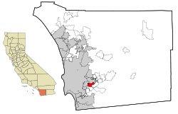
Thousand Palms is a census-designated place (CDP) in the Coachella Valley of Riverside County, California, United States. The population was 7,715 at the 2010 census, up from 5,120 at the 2000 census.

<span class="mw-page-title-main">La Presa, California</span> Census-designated place in California, United States

La Presa is a census-designated place (CDP) in the East County region of San Diego County, California, United States. The population was 34,169 at the 2010 census, up from 32,721 at the 2000 census.

<span class="mw-page-title-main">Spring Valley, San Diego County, California</span> Census-designated place in California, United States

Spring Valley is a census-designated place (CDP) in the East County region of San Diego County, California. The population was 28,205 at the time of the 2010 census.

<span class="mw-page-title-main">El Verano, California</span> Census-designated place in California, United States

El Verano is a census-designated place (CDP) in Sonoma Valley, Sonoma County, California, United States. The population was 4,123 at the 2010 census, falling to 3,867 at the 2020 census.

<span class="mw-page-title-main">Casa Conejo, California</span> Unincorporated area in Ventura County, California, United States

Casa Conejo is an unincorporated county island in Newbury Park, Ventura County, California, United States. It was the first planned community in Newbury Park and began building in 1960. When the city of Thousand Oaks incorporated 4 years later, the new developments in Newbury Park were incorporated into the city boundaries before being subdivided. The community is bordered by Old Conejo Road and US 101 to the north, Borchard Road to the south, Jenny Drive to the west, and Sequoia Middle School to the east. For statistical purposes, the United States Census Bureau has defined Casa Conejo as a census-designated place (CDP). The census definition of the area may not precisely correspond to local understanding of the area with the same name. The population was 3,249 at the 2010 census, up from 3,180 at the 2000 census. Casa Conejo is located in a roughly rectangle-shaped unincorporated area surrounded by the city of Thousand Oaks.

<span class="mw-page-title-main">Green Valley, Maryland</span> Census-designated place in Maryland

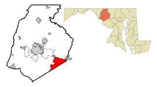
Green Valley is an unincorporated area and census-designated place (CDP) in southern Frederick County, Maryland, United States. The population was 12,643 at the 2020 census. The area was listed as a census-designated place in 2000 but not listed as part of any CDP at the 2010 census. It was re-designated a census-designated place for the 2020 census.

<span class="mw-page-title-main">Rancho Calaveras, California</span> Census-designated place in California, United States

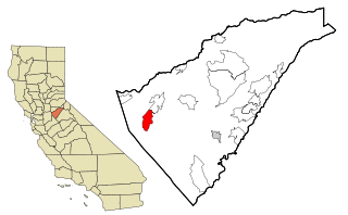
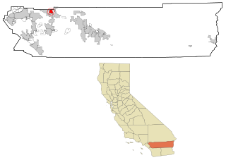
Rancho Calaveras is a census-designated place (CDP) in Calaveras County, California, United States. The population was 5,325 at the 2010 census, up from 4,182 at the 2000 census.

<span class="mw-page-title-main">Spring Creek, Nevada</span> CDP in Nevada, United States

Spring Creek is a census-designated place (CDP) in central Elko County, in northeastern Nevada in the western United States. It mainly serves as a bedroom community for the businesses and industries in and around the nearby city of Elko. It is part of the Elko Micropolitan Statistical Area. The population was 12,361 at the 2010 census.

<span class="mw-page-title-main">Paraje, New Mexico</span> Census-designated place in New Mexico, United States

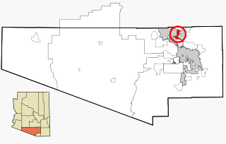
Paraje is a census-designated place (CDP) in Cibola County, New Mexico, United States. As of the 2010 census, the CDP population was 777.

<span class="mw-page-title-main">Spring Mount, Pennsylvania</span> Census-designated place in Pennsylvania, United States

Spring Mount is a census-designated place (CDP) in Montgomery County, Pennsylvania, United States. The population was 2,259 at the 2010 census.

<span class="mw-page-title-main">Mount Gay-Shamrock, West Virginia</span> Census-designated place in West Virginia, United States

Mount Gay-Shamrock is a census-designated place (CDP) in Logan County, West Virginia, United States.

References

  1. "2020 U.S. Gazetteer Files". United States Census Bureau. Retrieved October 30, 2021.
  2. Fetzer, Leland (2005). San Diego County Place Names A to Z. San Diego: Sunbelt Publications. p. 61. According to the snail theory, the name resulted from a visit made by ... Louis Agassiz, who came to San Diego in August 1872 aboard the research vessel Hassler. He made a collecting trip ... including the Spring Valley area, where he collected specimens of Helisx aspersa, a snail never recorded before in the region ... Rufus K. Porter named the hill in his honor, giving it the snail name ... The snail theory is well authenticated and convincing.
  3. "US Gazetteer files: 2010, 2000, and 1990". United States Census Bureau. February 12, 2011. Retrieved April 23, 2011.
  4. "Census of Population and Housing". Census.gov. Retrieved June 4, 2016.
  5. "2010 Census Interactive Population Search: CA - Casa de Oro-Mount Helix CDP". U.S. Census Bureau. Archived from the original on July 15, 2014. Retrieved July 12, 2014.
  6. "U.S. Census website". United States Census Bureau . Retrieved January 31, 2008.
  7. "Statewide Database". UC Regents. Archived from the original on February 1, 2015. Retrieved December 8, 2014.