The Erie Canal is a historic canal in upstate New York that runs east–west between the Hudson River and Lake Erie. Completed in 1825, the canal was the first navigable waterway connecting the Atlantic Ocean to the Great Lakes, vastly reducing the costs of transporting people and goods across the Appalachians. In effect, the canal accelerated the settlement of the Great Lakes region, the westward expansion of the United States, and the economic ascendancy of New York State. It has been called "The Nation's First Superhighway."

St. Johnsville is a town in Montgomery County, New York, United States. The population was 2,631 at the 2010 census. Accounts vary as to the etymology of St. Johnsville, but most of them state that the town and its village are named after an early surveyor and commissioner, Alexander St. John. Still others credit the naming of St. Johnsville to a former name for the area, St. John's Church.

Macedon is a town in Wayne County, New York, United States. The population was 9,148 at the 2010 census.
The Morris Canal (1829–1924) was a 107-mile (172 km) common carrier anthracite coal canal across northern New Jersey that connected the two industrial canals in Easton, Pennsylvania across the Delaware River from its western terminus at Phillipsburg, New Jersey to New York Harbor and New York City through its eastern terminals in Newark and on the Hudson River in Jersey City. The canal was sometimes called the Morris and Essex Canal, in error, due to confusion with the nearby and unrelated Morris and Essex Railroad.

The Miami and Erie Canal was a 274-mile (441 km) canal that ran from Cincinnati to Toledo, Ohio, creating a water route between the Ohio River and Lake Erie. Construction on the canal began in 1825 and was completed in 1845 at a cost to the state government of $8 million. At its peak, it included 19 aqueducts, three guard locks, 103 canal locks, multiple feeder canals, and a few man-made water reservoirs. The canal climbed 395 feet (120 m) above Lake Erie and 513 feet (156 m) above the Ohio River to reach a topographical peak called the Loramie Summit, which extended 19 miles (31 km) between New Bremen, Ohio to lock 1-S in Lockington, north of Piqua, Ohio. Boats up to 80 feet long were towed along the canal by mules, horses, or oxen walking on a prepared towpath along the bank, at a rate of four to five miles per hour.

The Ohio and Erie Canal was a canal constructed during the 1820s and early 1830s in Ohio. It connected Akron with the Cuyahoga River near its outlet on Lake Erie in Cleveland, and a few years later, with the Ohio River near Portsmouth. It also had connections to other canal systems in Pennsylvania.

The Delaware and Hudson Canal was the first venture of the Delaware and Hudson Canal Company, which would later build the Delaware and Hudson Railway. Between 1828 and 1899, the canal's barges carried anthracite coal from the mines of northeastern Pennsylvania to the Hudson River and thence to market in New York City.

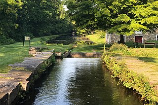
The New York State Canal System is a successor to the Erie Canal and other canals within New York. The 525-mile (845 km) system is composed of the Erie Canal, the Oswego Canal, the Cayuga–Seneca Canal, and the Champlain Canal. In 2014 the entire system was listed as a national historic district on the National Register of Historic Places, and in 2016 it was designated a National Historic Landmark.

The Cayuga–Seneca Canal is a canal in New York, United States. It is now part of the New York State Canal System.

The Champlain Canal is a 60-mile (97 km) canal in New York that connects the Hudson River to the south end of Lake Champlain. It was simultaneously constructed with the Erie Canal for use by commercial vessels, fully opening in 1823. Today, it is mostly used by recreational boaters as part of the New York State Canal System and Lakes to Locks Passage.
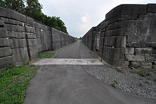
Schoharie Crossing State Historic Site, also known as Erie Canal National Historic Landmark, is a historic district that includes the ruins of the Erie Canal aqueduct over Schoharie Creek, and a 3.5-mile (5.6 km) long part of the Erie Canal, in the towns of Glen and Florida within Montgomery County, New York. It was the first part of the old canal to be designated a National Historic Landmark, prior to the designation of the entire New York State Barge Canal as an NHL in 2017.
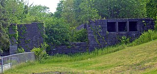
Lock 18 of the Enlarged Erie Canal is located off North Mohawk Street in Cohoes, New York, United States. It is made of stone blocks 3 by 2 by 1.5 feet in size, roughly 150 feet (46 m) in length, laid in a random ashlar pattern. The lock's wooden gates are no longer extant.

Day Peckinpaugh is a historic canal motorship berthed at the Matton Shipyard on Peebles Island, Cohoes in Albany County, New York, United States.
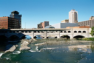
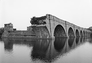
Erie Canal: Second Genesee Aqueduct, also known as the Broad Street Aqueduct or Broad Street Bridge, is a historic stone aqueduct located at Rochester in Monroe County, New York. It was constructed in 1836–1842 and originally carried the Erie Canal over the Genesee River. The overall length of the aqueduct including the wings and abutments is 800 feet (240 m). The aqueduct is 70 feet (21 m) wide and has large parapets on either side. It is one of four major aqueducts in the mid-19th century Erie Canal system. In 1927, a roadbed was added to carry automobile traffic and named Broad Street. It also carried a part of the Rochester Subway.
Erie Canal Lock 52 Complex is a national historic district located at Port Byron and Mentz in Cayuga County, New York. The district includes two contributing buildings ; three contributing engineering structures ; and archaeological sites associated with the canal operations. Lock 52 was constructed 1849-1853 as part of the Enlarged Erie Canal program. It remained in operation until the rerouting of the canal under the New York State Barge Canal System in 1917. The Erie House was built in 1894 and is a two-story frame structure that housed a saloon and hotel.

Lyons is a town in and the county seat of Wayne County, New York, United States. The population was 5,682 at the 2010 census. It is named after Lyon, France.

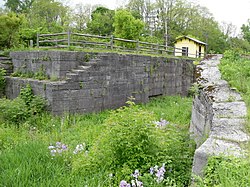
Enlarged Double Lock No. 33 Old Erie Canal is a historic Erie Canal lock located at St. Johnsville in Montgomery County, New York. It was built in 1824 and enlarged in 1840. The south lock was enlarged in 1888. It is built entirely of large cut limestone blocks mortared with hydraulic cement. Lock 33 fell into disuse after the opening of the New York State Barge Canal in 1918. Since 1997, it has been reclaimed and restored by local volunteers.
Lock Berlin is a hamlet in the Town of Galen, Wayne County, New York, United States. It is located four miles (6 km) west of the Village of Clyde and three miles (5 km) northeast of the hamlet of Lyons, at an elevation of 404 feet. The primary cross roads where the hamlet is located are Old Route 31, Stokes Road, Lock Berlin Road and Maple Street. N.Y. Route 31 passes just south of Lock Berlin.
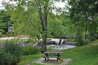
Songo Lock is the last surviving lock of the Cumberland and Oxford Canal, a 19th-century canal in southern Maine, United States. The lock is located on the Songo River, just above its confluence with the Crooked River at the northern end of Sebago Lake State Park in the town of Naples. The lock, built in 1830, is now used primarily during the summer months by pleasure craft. It was listed on the National Register of Historic Places in 1970 and designated as a Maine Historic Civil Engineering Landmark by the American Society of Civil Engineers in 2001.

The Waterford Flight is a set of locks on the Erie Canal in upstate New York. Erie Canal Locks E-2 through E-6 make up the combined flight at Waterford, which lifts vessels from the Hudson River to the Mohawk River, bypassing Cohoes Falls. Built in 1915, the Waterford Flight is still in use today as part of the New York State Canal System, which is open to public and commercial traffic. The Waterford Flight is the series of locks with the highest elevation gain relative to its length for any canal lock system in the United States.