Cheam is a commuter suburb now in the London Borough of Sutton, England, 10.9 miles (17.5 km) south-west of Charing Cross. It divides into North Cheam, Cheam Village and South Cheam. Cheam Village contains the listed buildings Lumley Chapel and the 16th-century Whitehall. It is adjacent to two large parks, Nonsuch Park and Cheam Park. Nonsuch Park contains the listed Nonsuch Mansion. Parts of Cheam Park and Cheam Village are in a conservation area. Cheam is bordered by Worcester Park to the north-west, Morden to the north-east, Sutton to the east, Ewell and Stoneleigh to the west and Banstead and Belmont to the south.
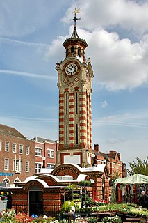
Epsom is the principal town of the Borough of Epsom and Ewell in Surrey, England, approximately 13.5 mi (21.7 km) south of central London. The town is first recorded as Ebesham in the 10th century and its name probably derives from that of a Saxon landowner. The earliest evidence of human activity is from the mid-Bronze Age, but the modern settlement probably grew up in the area surrounding St Martin's Church in the 6th or 7th centuries and the street pattern is thought to have become established in the Middle Ages. Today the High Street is dominated by the clock tower, which was erected in 1847-8.

Epsom and Ewell is a local government district with borough status in Surrey, England, covering the towns of Epsom and Ewell. The borough was formed as an urban district in 1894, and was known as Epsom until 1934. It was made a municipal borough in 1937. The district was considered for inclusion in Greater London in 1965 but was left unaltered by the London Government Act 1963 and the Local Government Act 1972 in 1974. However, despite being outside modern Greater London the borough was in the Metropolitan Police District until it was transferred to Surrey Police in 2000. In the May 2019 elections, the borough was held by the Epsom and Ewell Residents Association with 32 seats, Labour with 3 seats, Liberal Democrats with 2 seats, and Conservatives with 1 seat.
The Residents Associations of Epsom and Ewell is a local political party in the borough of Epsom and Ewell in Surrey, England. They have held majority control of Epsom and Ewell Borough Council since its formation in 1937. The party is sometimes recorded as Other in national results lists and otherwise recorded alongside residents associations with a single Articles of Association. It consists of ward or multiple ward based residents associations with their own candidate selection rules. These include Ewell Court Residents' Association, Epsom Town Residents' Association and West Ewell and Ruxley Residents’ Association.

The Hogsmill River in Surrey and Greater London, England is a small chalk stream tributary of the River Thames. It rises in Ewell and flows into the Thames at Kingston upon Thames on the lowest non-tidal reach, that above Teddington Lock.

Ewell is a suburban area with a village centre in the borough of Epsom and Ewell in Surrey, approximately 13 miles (21 km) south of central London and 1.5 miles (2.4 km) northeast of Epsom. In the 2011 Census, the settlement had a population of 34,872, a majority of which (73%) is in the ABC1 social class, except the Ruxley Ward that is C2DE.

Worcester Park is a town in Southwest London, England. It lies in the London boroughs of Sutton and Kingston, and partly in the Surrey borough of Epsom and Ewell. The area is 10.1 miles (16.3 km) southwest of Charing Cross. The suburb's population was 16,031 at the time of the 2001 census. The suburb comprises the Worcester Park ward, an electoral area of the London Borough of Sutton with a population in 2011 of 11,655, as well as the Cuddington ward, an electoral area of Epsom and Ewell, which had a population of 5,791 at the time of the 2001 census.

The A232 is a road running west-east across South London, which connects the A24 in Ewell with the A224 Orpington bypass.

Nork is a residential area of the borough of Reigate and Banstead in Surrey and borders Greater London, England. Nork is separated from its post town Banstead only by the A217 dual carriageway, and the built-up area is also contiguous with similar parts of Tattenham Corner and Burgh Heath. A thin belt of more open land separates it from the communities to the north: Epsom, Ewell, Cheam and Belmont. There are two parades of shops, one called the Driftbridge and another at the north-eastern end of Nork Way, the street which runs centrally through the residential area. Nork lies on chalk near the top of the gentle north-facing slope of the North Downs, 175 m (575 ft) above sea level at its highest point.
Stoneleigh is a suburb to the southwest of London, in the north of the Epsom and Ewell borough in Surrey, England. It is situated approximately 11 miles (18 km) from central London. In the 2011 Census, the population was 8741.

Surrey County Council is the county council administering certain services in the non-metropolitan county of Surrey in England. The council is composed of 81 elected councillors, and in all but one election since 1965 the Conservative Party has held the majority. The leader of the council is Tim Oliver.

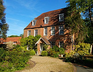
Nonsuch Park is a public park between Stoneleigh, Cheam, and East Ewell in the borough of Epsom and Ewell in Surrey, England. It is adjacent to the boundary of the London Borough of Sutton. It is the last surviving part of the Little Park of Nonsuch, a deer hunting park established by Henry VIII of England surrounding the former Nonsuch Palace.
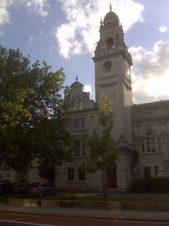
County Hall is a former municipal building in Penrhyn Road, Kingston upon Thames, England. The building, which was the headquarters of Surrey County Council from 1893 to 2020, is a landmark in Kingston and is a Grade II listed building.

Bugby Chapel is an 18th-century former chapel in the centre of Epsom, a suburban town in Surrey, England. Known by this name in reference to its Calvinistic founder William Bugby, it was also known as East Street Chapel and later, as it passed into the ownership of different religious groups, as Salem Unitarian Chapel, Salem Baptist Chapel and the Epsom and District Synagogue. More than 200 years of religious use ended when it was converted into an office. The chapel is a Grade II Listed building.
The 2015 Epsom and Ewell Council election took place on 7 May 2015 to elect members of Epsom and Ewell Council in England as one of the 2015 United Kingdom local elections and coinciding with the general election leading to a higher turnout than when local elections are held in a non-general election year.

The Old Town Hall, Richmond on Whittaker Avenue in Richmond, London is a former municipal building which from 1893 to 1965 served as the town hall for the Municipal Borough of Richmond.
Wallington Town Hall is a municipal building in Woodcote Road, Wallington, London. It is a Grade II listed building.
The 2019 Epsom and Ewell Borough Council election took place on 2 May 2019 to elect members of Epsom and Ewell Borough Council. This was on the same day as other local elections. The entire council was up for election. The result was a gain for the incumbent Residents Associations of Epsom and Ewell, gaining 2 seats from the Conservatives but losing 1 to them as well. The Liberal Democrats regained representation on the council, gaining 2 seats from the Conservatives.

