
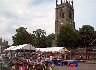
Ilkeston is a town in the Borough of Erewash, Derbyshire, England, on the River Erewash, from which the borough takes its name, with a population at the 2011 census of 38,640. Its major industries, coal mining, iron working and lace making/textiles, have now all but disappeared.
Erewash is a local government district with borough status in Derbyshire, England, to the east of Derby and the west of Nottingham. The population of the district as taken at the 2011 Census was 112,081. It contains the towns of Ilkeston, Long Eaton and Sandiacre and fourteen civil parishes.

The Erewash Canal is a broad canal in Derbyshire, England. It runs just under 12 miles (19 km) and has 14 locks. The first lock at Langley Bridge is part of the Cromford Canal.
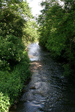
The River Erewash is a river in England, a tributary of the River Trent that flows roughly southwards through Derbyshire, close to its eastern border with Nottinghamshire.

Erewash is a county constituency represented in the House of Commons of the UK Parliament since 2015 by Maggie Throup, a Conservative.
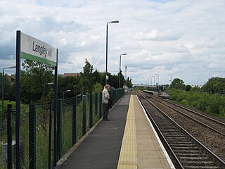
Langley Mill railway station on the Erewash Valley Line serves the village of Langley Mill and the towns of Heanor in Derbyshire and Eastwood in Nottinghamshire, England. The station is 12 miles (19 km) north of Nottingham.
Kegworth railway station located in Nottinghamshire was a station serving the villages of Kegworth, Leicestershire, Sutton Bonington, and Kingston on Soar, Nottinghamshire.
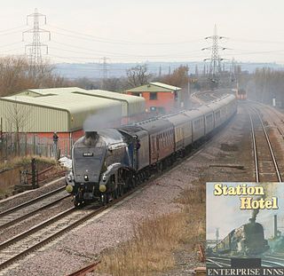
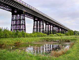
The Erewash Valley Line is a railway line in England, running from Long Eaton, located between Nottingham and Derby, and Clay Cross, near Chesterfield. The southern part was opened by the Midland Railway in 1847 as far as Codnor Park, where it connected to established ironworks, and soon after, a line to Pinxton and Mansfield.

Breadsall is a village and civil parish in the English county of Derbyshire, grid reference SK370397. The population of the civil parish at the 2011 census was 773. Breadsall Priory is nearby.
Ilkeston North railway station was a railway station in Ilkeston, Derbyshire. It was opened by the Great Northern Railway on its Derbyshire Extension in 1878 and closed in 1964.
Mapperley is a village and civil parish in the Amber Valley district of Derbyshire, England, situated 7 miles (11 km) northeast of Derby and 2 miles (3 km) northwest of Ilkeston. In the 2001 census it had a population of 253, increasing to 289 at the 2011 Census.

Erewash Sound is a community radio station broadcasting to the borough of Erewash in Derbyshire, including Ilkeston, West Hallam, Long Eaton, Borrowash and surrounding areas.
Ilkeston Junction and Cossall railway station was a railway station which served the town of Ilkeston in Derbyshire, England.
Crosshill and Codnor railway station was a railway station which served the villages of Crosshill and Codnor in Derbyshire, England It was opened in 1890 by the Midland Railway on its branch between Langley Mill on the Erewash Valley Line and Ripley
Heanor railway station was a railway station which served the town of Heanor in Derbyshire, England. It was opened in 1890 by the Midland Railway on its branch between Langley Mill (Branch) railway station on the Erewash Valley Line and Ripley

Ilkeston Town Hall is a municipal building in the Market Place, Ilkeston, Derbyshire. The town hall, which currently serves as one of two meeting places of Erewash Borough Council, is a Grade II listed building.
Ilkeston was a Municipal Borough in Derbyshire, England from 1887 to 1974. It was formed under the Municipal Corporations Act 1882.
Long Eaton was an Urban District in Derbyshire, England from 1894 to 1974. It was created under the Local Government Act 1894.
Ilkeston is a town and unparished area in the Borough of Erewash in Derbyshire, England. The town and surrounding area contain 28 listed buildings that are recorded in the National Heritage List for England. Of these, one is listed at Grade I, the highest of the three grades, three are at Grade II*, the middle grade, and the others are at Grade II, the lowest grade. The Erewash Canal passes through the area, and the listed buildings associated with it are two bridges and two locks. The other listed buildings include churches and a chapel, a church tower, houses, a museum, the town hall, two factories, a drinking fountain, a brick kiln, a library, cemetery buildings, two cinemas, a school, and two war memorials.
