Erling Dorf was an American geologist. He was born July 19, 1905, and died in April 1984. He was hired in 1928 as a professor of geology at Princeton University. He retired from Princeton in 1974. He was a renowned paleobotanist working on the floras of the Late Cretaceous and Paleogene. He was married to Ruth Kemmerer Dorf. They had three sons and a daughter: Thomas Alfred Dorf (1937-1958), Norman Kemmerer Dorf (1938-2007), Robert "Bob" Erling Dorf (1941- ) and Molly Dorf Purrington (1948 - ).[1]
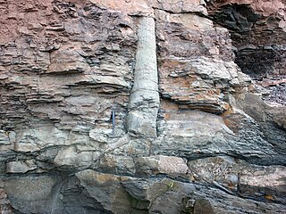
Probably his best known research today are comprehensive articles and papers about the Yellowstone Petrified Forest where he reported the presence of conglomerates from stream deposits, breccias from mudflows or landslides, volcanictuff from the numerous volcanic events, and lava beds.[1][2] Dorf theorized that these specimens do not merely represent one entombed forest but rather include trees from 27 separate forests (the most in the world), each stacked on top of the other, layer by layer, to a thickness of 1,200 feet (370m). He explains that the Absaroka volcanism lasted for 15 million years. In that time, there were alternating periods of activity and dormancy. The active periods caused trees to be encased and eventually fossilized. During the ensuing dormancy, new trees grew up on top of the old, only to be encased by the next volcanic activity.[2][3]
Chaney, Ralph Works and Erling Dorf "Ecology of the Tertiary forests of western North America" Proceedings of the Geological Society of America, pp.357, Jun 1934
Dorf, Erling and John R. Cooper "Early Devonian Plants from Newfoundland" Journal of Paleontology, Vol. 17, No. 3, pp.264–270. May, 1943
Dorf, Erling and Steven K. Fox "Cretaceous and Cenozoic of the New Jersey Coastal Plain" Prepared for the 1957 annual meeting of the Geological Society of America and associated societies." 1957
Dorf, Erling "Climatic changes of the past and present" American Scientist, vol.48, no.3, pp.341–364, 1960
Dorf, Erling "The petrified forests of Yellowstone Park" Scientific American, vol.210, no.4, pp.106–112, 1964
Dorf, Erling "Cretaceous Insects From Labrador I. Geologic Occurrence," Psyche, vol. 74, no. 4, pp.267–269, 1967
Dorf, Erling "The fossil forests of yellowstone park" Science and Children, vol.7, no.6, pp.15–17, 1970
Dorf, Erling "Early Tertiary fossil forests of Yellowstone Park" from Rock mechanics, the American Northwest. Pennsylvania State University Press, pages 108–111. 1974
Dorf, E. "Climatic changes of the past and present" in the book, Paleobiogeography from the series (edited by C.A. Ross), Benchmark papers in geology. Dowden, Hutchinson & Ross, Inc., Pages 384-412 (1976)
Dorf, Erling "Petrified forests of Yellowstone: Yellowstone National Park, Wyoming, Montana, and Idaho" National Park Service Handbook No. 108 (1980)
1 2 Fritz, WJ (1980a) Depositional Environment of the Eocene Lamar River Formation in Yellowstone National Park. Doctoral Dissertation, The University of Montana, Missoula, Montana.
Yellowstone National Park is a national park of the United States located in the northwest corner of Wyoming and extending into Montana and Idaho. It was established by the 42nd U.S. Congress through the Yellowstone National Park Protection Act and signed into law by President Ulysses S. Grant on March 1, 1872. Yellowstone was the first national park in the U.S. and is also widely held to be the first national park in the world. The park is known for its wildlife and its many geothermal features, especially the Old Faithful geyser, one of its most popular. While it represents many types of biomes, the subalpine forest is the most abundant. It is part of the South Central Rockies forests ecoregion.
The Absaroka Range is a sub-range of the Rocky Mountains in the United States. The range stretches about 150 mi (240 km) across the Montana–Wyoming border, and 75 mi (120 km) at its widest, forming the eastern boundary of Yellowstone National Park along Paradise Valley, and the western side of the Bighorn Basin. The range borders the Beartooth Mountains to the north and the Wind River Range to the south. The northern edge of the range rests along I-90 and Livingston, Montana. The highest peak in the range is Francs Peak, located in Wyoming at 13,153 ft (4,009 m). There are 46 other peaks over 12,000 ft (3,700 m).
Petrified wood, is the name given to a special type of fossilized wood, the fossilized remains of terrestrial vegetation. Petrifaction is the result of a tree or tree-like plants having been replaced by stone via a mineralization process that often includes permineralization and replacement. The organic materials making up cell walls have been replicated with minerals. In some instances, the original structure of the stem tissue may be partially retained. Unlike other plant fossils, which are typically impressions or compressions, petrified wood is a three-dimensional representation of the original organic material.
The Bighorn Mountains are a mountain range in northern Wyoming and southern Montana in the United States, forming a northwest-trending spur from the Rocky Mountains extending approximately 200 mi (320 km) northward on the Great Plains. They are separated from the Absaroka Range, which lie on the main branch of the Rockies to the west, by the Bighorn Basin. Much of the land is contained within the Bighorn National Forest.
A polystrate fossil is a fossil of a single organism that extends through more than one geological stratum. The word polystrate is not a standard geological term. This term is typically found in creationist publications.
Heart Mountain is an 8,123-foot (2,476 m) klippe just north of Cody in the U.S. state of Wyoming, rising from the floor of the Bighorn Basin. The mountain is composed of limestone and dolomite of Ordovician through Mississippian age, but it rests on the Willwood Formation, rocks that are about 55 million years old—the rocks on the summit of Heart Mountain are almost 300 million years older than the rocks at the base. For over one hundred years, geologists have tried to understand how these older rocks came to rest on much younger strata.
The Gallatin Range is a mountain range of the Rocky Mountains, located in the U.S. states of Montana and Wyoming. It includes more than 10 mountains over 10,000 feet (3,000 m). The highest peak in the range is Electric Peak at 10,969 feet (3,343 m).
Eagle Peak is a mountain in the Absaroka Range in the U.S. state of Wyoming and at 11,372 feet (3,466 m) is the highest point in Yellowstone National Park. It is located about 6 miles (9.7 km) east of the southeast arm of Yellowstone Lake.
The Cloverly Formation is a geological formation of Early and Late Cretaceous age that is present in parts of Montana, Wyoming, Colorado and Utah in the western United States. It was named for a post office on the eastern side of the Bighorn Basin in Wyoming by N.H. Darton in 1904. The sedimentary rocks of formation were deposited in floodplain environments and contain vertebrate fossils, including a diverse assemblage of dinosaur remains. In 1973, the Cloverly Formation Site was designated as a National Natural Landmark by the National Park Service.
The Fort Union Formation is a geologic unit containing sandstones, shales, and coal beds in Wyoming, Montana, and parts of adjacent states. In the Powder River Basin, it contains important economic deposits of coal, uranium, and coalbed methane.
The Mowry Shale is an Early Cretaceous geologic formation. The formation was named for Mowrie Creek, northwest of Buffalo in Johnson County, Wyoming.
Specimen Ridge, el. 8,379 feet (2,554 m) is an approximately 8.5-mile (13.7 km) ridge along the south rim of the Lamar Valley in Yellowstone National Park. The ridge separates the Lamar Valley from Mirror Plateau. The ridge is oriented northwest to southeast from the Tower Junction area to Amethyst Mountain. The ridge is known for its abundance of amethyst, opal and petrified wood. It was referred to as Specimen Mountain by local miners and was probably named by prospectors well before 1870. The south side of the ridge is traversed by the 18.8-mile (30.3 km) Specimen Ridge Trail between Tower Junction and Soda Butte Creek. The trail passes through the Petrified Forest and over the summit of Amethyst Mountain el. 9,614 feet (2,930 m).
The Raynolds Expedition was a United States Army exploring and mapping expedition intended to map the unexplored territory between Fort Pierre, Dakota Territory and the headwaters of the Yellowstone River. The expedition was led by topographical engineer Captain William F. Raynolds.
Paleontology in Mississippi refers to paleontological research occurring within or conducted by people from the U.S. state of Mississippi. The oldest rocks in Mississippi date back to the Late Devonian. At the time, the northeastern part of the state was covered in a sea where brachiopods, crinoids, and trilobites lived. Remains of contemporary local plants also ended up preserved in this environment. During the Late Carboniferous, Mississippi became part of a richly-vegetated coastal plain environment. There are no rocks dating to the Permian, Triassic, or Jurassic in the state. However, during the Cretaceous, evidence suggests that the state was covered by a sea home to cephalopods, mosasaurs and sharks. Local trees left behind petrified wood and amber. By the Cenozoic, only the southern half of the state was covered in seawater, where the early whale Basilosaurus lived. On land, trees that were home to some of the earliest known primates left behind petrified wood. For the remainder of the Cenozoic, the state's climate cooled. Many fossils have been serendipitously discovered in the state by people looking for fossil fuels. Significant fossil finds in Mississippi include some of the oldest known primate fossils. The Eocene whales Basilosaurus cetoides and Zygorhiza kochii are the Mississippi state fossils.
Paleontology in North Dakota refers to paleontological research occurring within or conducted by people from the U.S. state of North Dakota. During the early Paleozoic era most of North Dakota was covered by a sea home to brachiopods, corals, and fishes. The sea briefly left during the Silurian, but soon returned, until once more starting to withdraw during the Permian. By the Triassic some areas of the state were still under shallow seawater, but others were dry and hot. During the Jurassic subtropical forests covered the state. North Dakota was always at least partially under seawater during the Cretaceous. On land Sequoia grew. Later in the Cenozoic the local seas dried up and were replaced by subtropical swamps. Climate gradually cooled until the Ice Age, when glaciers entered the area and mammoths and mastodons roamed the local woodlands.
Paleontology in Idaho refers to paleontological research occurring within or conducted by people from the U.S. state of Idaho. The fossil record of Idaho spans much of the geologic column from the Precambrian onward. During the Precambrian, bacteria formed stromatolites while worms left behind trace fossils. The state was mostly covered by a shallow sea during the majority of the Paleozoic era. This sea became home to creatures like brachiopods, corals and trilobites. Idaho continued to be a largely marine environment through the Triassic and Jurassic periods of the Mesozoic era, when brachiopods, bryozoans, corals, ichthyosaurs and sharks inhabited the local waters. The eastern part of the state was dry land during the ensuing Cretaceous period when dinosaurs roamed the area and trees grew which would later form petrified wood.
A substantial amount of paleontological research has occurred within or conducted by people from the United States. Paleontologists have found that at the start of the Paleozoic era, what is now "North" America was actually in the southern hemisphere. Marine life flourished in the country's many seas. Later the seas were largely replaced by swamps, home to amphibians and early reptiles. When the continents had assembled into Pangaea drier conditions prevailed. The evolutionary precursors to mammals dominated the country until a mass extinction event ended their reign.
Gregory John Retallack is an Australian paleontologist, geologist, and author who specializes in the study of fossil soils (paleopedology). His research has examined the fossil record of soils though major events in Earth history, extending back some 4.6 billion years. He has written two textbooks on paleopedology.
Amethyst Mountain, el. 9,609 feet (2,929 m) is the highest peak and central part of a northwest – southeast trending ridge that lies between the Lamar River to the northeast and Deep Creek to the southwest within Park County, Wyoming. From northwest to southeast, this ridge consists of Specimen Ridge, Amethyst Mountain, and the Mirror Plateau in Yellowstone National Park. The nearest town is Silver Gate, Montana, which is 19.2 miles away.
The Thermopolis Shale is a geologic formation which formed in west-central North America in the Albian age of the Late Cretaceous period. Surface outcroppings occur in central Canada, and the U.S. states of Montana and Wyoming. The rock formation was laid down over about 7 million years by sediment flowing into the Western Interior Seaway. The formation's boundaries and members are not well-defined by geologists, which has led to different definitions of the formation. Some geologists conclude the formation should not have a designation independent of the formations above and below it. A range of invertebrate and small and large vertebrate fossils and coprolites are found in the formation.
This page is based on this Wikipedia article Text is available under the CC BY-SA 4.0 license; additional terms may apply. Images, videos and audio are available under their respective licenses.