Eromanga Sea

Last updated
The Great Artesian Basin is a remnant of the inland Eromanga Sea Great Artesian Basin.png
The Great Artesian Basin is a remnant of the inland Eromanga Sea

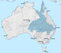
The Eromanga Sea was an inland sea across what would be Australia that formed in the Early Cretaceous. The sea reached the Eromanga Basin from the north via the Carpentarian Basin. The southern end of the sea comprised lagoons and rivers, and to the east in Surat Basin a bay. [1] [2]

It covered large parts of Queensland and Central Australia at least four times during the early Cretaceous.[ citation needed ] The Winton Formation represent remnants of the river plains that filled the basin left by the Eromanga Sea. The formation is a major source of dinosaur fossils.

Opals

The Great Artesian Basin (GAB) was flooded by the Eromanga Sea and filled with volcaniclastic sediments eroded from the Cordillera's volcanic arc. A theory was proposed explaining the abundance of opals in GAB. It was suggested that the Eromanga Sea was shallow, cold, muddy, and stagnant, which have led to little amount of carbonates in sediments in the Eromanga Basin. However the abundance of iron-rich and organic sediments have led to an anoxic sub-seafloor well-suited for anaerobic, pyrite-producing bacteria. It was suggested that during the periods of uplift, erosion, and denudation opals were formed due to acidic oxidative weathering during 97 to 60 Ma. [3] [4] [5]

Related Research Articles

<span class="mw-page-title-main">Great Artesian Basin</span> Large Artesian aquifer in Australia

The Great Artesian Basin (GAB), located in Australia, is the largest and deepest artesian basin in the world, stretching over 1,700,000 square kilometres (660,000 sq mi), with measured water temperatures ranging from 30 to 100 °C. The basin provides the only source of fresh water through much of inland Australia.

The Llano Uplift is a geologically ancient, low geologic dome that is about 90 miles (140 km) in diameter and located mostly in Llano, Mason, San Saba, Gillespie, and Blanco counties, Texas. It consists of an island-like exposure of Precambrian igneous and metamorphic rocks surrounded by outcrops of Paleozoic and Cretaceous sedimentary strata. At their widest, the exposed Precambrian rocks extend about 65 miles (105 km) westward from the valley of the Colorado River and beneath a broad, gentle topographic basin drained by the Llano River. The subdued topographic basin is underlain by Precambrian rocks and bordered by a discontinuous rim of flat-topped hills. These hills are the dissected edge of the Edwards Plateau, which consist of overlying Cretaceous sedimentary strata. Within this basin and along its margin are down-faulted blocks and erosional remnants of Paleozoic strata which form prominent hills.

<span class="mw-page-title-main">South Polar region of the Cretaceous</span> Animals that lived below the Antarctic circle in the Cretaceous

The South Polar region of the Cretaceous comprised the continent of East Gondwana–modern day Australia, Zealandia, and Antarctica–a product of the break-up of Gondwana in the Cretaceous Period. The southern region, during this time, was much warmer than it is today, ranging from perhaps 4–8 °C (39–46 °F) in the latest Cretaceous Maastrichtian in what is now southeastern Australia. This prevented permanent ice sheets from developing and fostered polar forests, which were largely dominated by conifers, cycads, and ferns, and relied on a temperate climate and heavy rainfall. Major fossil-bearing geological formations that record this area are: the Santa Marta and Sobral Formations of Seymour Island off the Antarctic Peninsula; the Snow Hill Island, Lopez de Bertodano, and the Hidden Lake Formations on James Ross Island also off the Antarctic Peninsula; and the Eumeralla and Wonthaggi Formations in Australia.

The Surat Basin is a geological basin in eastern Australia. It is part of the Great Artesian Basin drainage basin of Australia. The Surat Basin extends across an area of 270,000 square kilometres and the southern third of the basin occupies a large part of northern New South Wales, the remainder is in Queensland. It comprises Jurassic through to Cretaceous aged sediments derived from Triassic and Permian arc rocks of the Hunter-Bowen orogeny. Towns situated above the basin, once dominated by agriculture, are experiencing a boom as mines and infrastructure in the area are expanded.

<i>Umoonasaurus</i> Extinct species of reptile

Umoonasaurus is an extinct genus of plesiosaur belonging to the family Leptocleididae. This genus lived approximately 115 million years ago during the Early Cretaceous period, in shallow seas covering parts of what is now Australia. It was a relatively small animal around 2.5 metres (8.2 ft) long. An identifying trait of Umoonasaurus is three crest-ridges on its skull.

<span class="mw-page-title-main">Dakota Formation</span> Rock units in midwestern North America

The Dakota is a sedimentary geologic unit name of formation and group rank in Midwestern North America. The Dakota units are generally composed of sandstones, mudstones, clays, and shales deposited in the Mid-Cretaceous opening of the Western Interior Seaway. The usage of the name Dakota for this particular Albian-Cenomanian strata is exceptionally widespread; from British Columbia and Alberta to Montana and Wisconsin to Colorado and Kansas to Utah and Arizona. It is famous for producing massive colorful rock formations in the Rocky Mountains and the Great Plains of the United States, and for preserving both dinosaur footprints and early deciduous tree leaves.

The Eromanga Basin is a large Mesozoic sedimentary basin in central and northern Australia. It covers parts of Queensland, the Northern Territory, South Australia, and New South Wales, and is a major component of the Great Artesian Basin. The Eromanga Basin covers 1,000,000 km2 and overlaps part of the Cooper Basin.

<span class="mw-page-title-main">Winton Formation</span> Geological formation in Australia

The Winton Formation is a Cretaceous geological formation in central-western Queensland, Australia. It is late Albian to early Turonian in age. The formation blankets large areas of central-western Queensland. It consists of sedimentary rocks such as sandstone, siltstone and claystone. The sediments that make up these rocks represent the remnants of the river plains that filled the basin left by the Eromanga Sea - an inland sea that covered large parts of Queensland and central Australia at least four times during the Early Cretaceous. Great meandering rivers, forest pools and swamps, creeks, lakes and coastal estuaries all left behind different types of sediment.

<span class="mw-page-title-main">London Basin</span> The basin of river Thames in London

The London Basin is an elongated, roughly triangular sedimentary basin approximately 250 kilometres (160 mi) long which underlies London and a large area of south east England, south eastern East Anglia and the adjacent North Sea. The basin formed as a result of compressional tectonics related to the Alpine orogeny during the Palaeogene period and was mainly active between 40 and 60 million years ago.

<span class="mw-page-title-main">Siliceous ooze</span> Biogenic pelagic sediment located on the deep ocean floor

Siliceous ooze is a type of biogenic pelagic sediment located on the deep ocean floor. Siliceous oozes are the least common of the deep sea sediments, and make up approximately 15% of the ocean floor. Oozes are defined as sediments which contain at least 30% skeletal remains of pelagic microorganisms. Siliceous oozes are largely composed of the silica based skeletons of microscopic marine organisms such as diatoms and radiolarians. Other components of siliceous oozes near continental margins may include terrestrially derived silica particles and sponge spicules. Siliceous oozes are composed of skeletons made from opal silica SiO2·nH2O, as opposed to calcareous oozes, which are made from skeletons of calcium carbonate (CaCO3·nH2O) organisms (i.e. coccolithophores). Silica (Si) is a bioessential element and is efficiently recycled in the marine environment through the silica cycle. Distance from land masses, water depth and ocean fertility are all factors that affect the opal silica content in seawater and the presence of siliceous oozes.

The Toolebuc Formation is a geological formation that extends from Queensland across South Australia and the Northern Territory in Australia, whose strata date back to the Albian stage of the Early Cretaceous. Dinosaurs, pterosaurs, plesiosaurs, ichthyosaurs, protostegid turtles, sharks, chimaeroids and bony fish remains are among the fossils that have been recovered from the formation.

The Allaru Formation, also known as the Allaru Mudstone, is a geological formation in Queensland, Australia, whose strata date back to the Early Cretaceous. Dinosaur remains are among the fossils that have been recovered from the formation.

The Marree Subgroup, previously described as Maree Formation and Marree Formation, is a geological subgroup in the Eromanga Basin of South Australia whose strata date back to the Aptian. The subgroup was first described as a formation by Forbes in 1966. Dinosaur remains are among the fossils that have been recovered from the formation.

Geologically the Australian state of New South Wales consists of seven main regions: Lachlan Fold Belt, the Hunter-Bowen Orogeny or New England Orogen (NEO), the Delamerian Orogeny, the Clarence Moreton Basin, the Great Artesian Basin, the Sydney Basin, and the Murray Basin.

<span class="mw-page-title-main">Geology of Queensland</span>

The geology of Queensland can be subdivided into several regions with different histories. Along the east coast is a complex of Palaezoic to Cainozoic rocks while much of the rest of the state is covered by Cretaceous and Cainozoic rocks. A Precambrian basement is found in the north west and Cape York regions. The Thomson Orogen occurs in the central and southern parts of Queensland, but is mostly covered by younger basins.

<span class="mw-page-title-main">South West Queensland</span> Region in Queensland, Australia

South West Queensland is a remote region in the Australian state of Queensland which covers 319,808 km2 (123,479 sq mi). The region lies to the south of Central West Queensland and west of the Darling Downs and includes the Maranoa district and parts of the Channel Country. The area is noted for its cattle grazing, cotton farming, opal mining and oil and gas deposits.

<span class="mw-page-title-main">Galilee Basin</span> Sedimentary basin in Queensland, Australia

The Galilee Basin is a large inland geological basin in the western Queensland region of Australia. The Galilee Basin is part of a larger Carboniferous to Mid-Triassic basin system that contains the Cooper Basin, situated towards the south-west of the Galilee Basin, and the Bowen Basin to the east. The Galilee Basin covers a total area of approximately 247,000 square kilometres (95,000 sq mi). The basin is underlain by the Carboniferous Drummond Basin and overlain by the Cretaceous – Jurassic Eromanga Basin. The Triassic and younger sediments of the Galilee Basin form the basal sequence of the Great Artesian Basin drainage basin.

The geology of Nigeria formed beginning in the Archean and Proterozoic eons of the Precambrian. The country forms the Nigerian Province and more than half of its surface is igneous and metamorphic crystalline basement rock from the Precambrian. Between 2.9 billion and 500 million years ago, Nigeria was affected by three major orogeny mountain-building events and related igneous intrusions. Following the Pan-African orogeny, in the Cambrian at the time that multi-cellular life proliferated, Nigeria began to experience regional sedimentation and witnessed new igneous intrusions. By the Cretaceous period of the late Mesozoic, massive sedimentation was underway in different basins, due to a large marine transgression. By the Eocene, in the Cenozoic, the region returned to terrestrial conditions.

The Rolling Downs Group is a stratigraphic group present in the Eromanga and Surat Basins in eastern Australia, which was deposited between the mid Barremian to early Turonian of the Cretaceous period. It primarily consists of nearshore shallow marine sediments deposited in the Eromanga Sea, though the uppermost and terminal members, the Winton Formation and the Griman Creek Formation represents freshwater deposits. It is notable for its fossil content including many dinosaurs and mammals, as well as opal. A relict species of dicynodont was suggested to have been found in these rocks, but is more likely to be misidentified pieces of a Cenozoic marsupial from younger sediments.

The Bulldog Shale is a formation of Early Cretaceous age that forms part of the Marree Subgroup of the Rolling Downs Group, located in the Eromanga Basin of South Australia, Queensland and New South Wales.

References

  1. Dettmann, M. E.; Molnar, R. E.; Douglas, J. G. (1992). "Australian cretaceous terrestrial faunas and floras: biostratigraphic and biogeographic implications". Cretaceous Research. 13 (3): 207–262. doi:10.1016/0195-6671(92)90001-7.
  2. EROMANGA SEA
  3. P.F. Rey, Opalisation of the Great Artesian Basin (central Australia): an Australian story with a Martian twist, Australian Journal of Earth Sciences, May 22, 2013 doi : 10.1080/08120099.2013.784219
  4. MINERAL TREASURES - OPAL
  5. Tao Hsu, Andrew Lucas, and Vincent Pardieu SPLENDOR IN THE OUTBACK: A VISIT TO AUSTRALIA’S OPAL FIELDS

26°S140°E / 26°S 140°E / -26; 140