The menorah is a seven-branched candelabrum that is described in the Hebrew Bible and in later ancient sources as having been used in the Tabernacle and in the Temple in Jerusalem. Since ancient times, it has represented the Jewish people and Judaism in both the Land of Israel and the Diaspora, while in modern times it is represented on Israel's national emblem. The symbol has also been found in archaeological artifacts from ancient Samaritan, Christian and Islamic communities.

Adullam is an ancient ruin, formerly known by the Arabic appellation ʿAīd el Mâ, built upon a hilltop overlooking the Elah Valley, straddling the Green Line between Israel and the West Bank. In the late 19th century, the town was still in ruins. The hilltop ruin is also known by the name Khurbet esh-Sheikh Madkour, named after Madkour, one of the sons of the Sultan Beder, for whom is built a shrine (wely) and formerly called by its inhabitants Wely Madkour. The hilltop is mostly flat, with cisterns carved into the rock. The remains of stone structures which once stood there can still be seen. Sedimentary layers of ruins from the old Canaanite and Israelite eras, mostly potsherds, are noticeable everywhere, although olive groves now grow atop of this hill, enclosed within stone hedges. The villages of Aderet, Aviezer and Khirbet al-Deir are located nearby. The ruin lies about 3 km (1.9 mi) south of Moshav Neve Michael. The area around ancient Adullam between Bet Shemesh and Bet Guvrin was established in 1957 as "Adullam Region" and settled since then.

Gibeah is the name of three places mentioned in the Hebrew Bible, in the tribes of Benjamin, Judah, and Ephraim respectively.

Ramathaim-Zophim, also called Ramah and Ramatha in the Douay–Rheims Bible translation, is a city from the Hebrew Bible, the home town and resting place of prophet Samuel. The name of the town means "the heights of the views."

Jattir is a town in Judea mentioned several times in the Hebrew Bible. It was known as Iethira during the 4th century CE. It is identified with Horvat Yattir/Khirbet Attir, an archeological site in the southern Hebron Hills, located in modern day Israel.

Kedesh was an ancient Canaanite and later Israelite settlement in Upper Galilee, mentioned few times in the Hebrew Bible. Its remains are located in Tel Kedesh, 3 km northeast of the modern Kibbutz Malkiya in Israel on the Israeli-Lebanese border.

Zanoah is a moshav in central Israel. Located adjacent to Beit Shemesh, it falls under the jurisdiction of Mateh Yehuda Regional Council. In 2019 it had a population of 524.

Bethoron, also Beth-Horon, was the name of two adjacent ancient towns strategically located on the Gibeon-Aijalon road, guarding the "ascent of Beth-Horon". The towns are mentioned in the Hebrew Bible and in other ancient sources: Upper Bethoron appears in Joshua 16:5 and Lower Bethoron in Joshua 16:3 and 1 Chronicles 7:24 and I Maccabees 3:16.

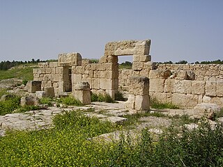
Tel Maresha is the tell of the biblical Iron Age city of Maresha, and of the subsequent, post-586 BCE Idumean city known by its Hellenised name Marisa, Arabised as Marissa (ماريسا). The tell is situated in Israel's Shephelah region, i.e. in the foothills of the Judaean Mountains, about 2 kilometres (1.2 mi) southeast of Beit Gubrin. It was first excavated in 1898-1900 by the British archaeologists Bliss and Macalister on behalf of the Palestine Exploration Fund and again after 1989 by Israeli archaeologist Amos Kloner on behalf of the Israel Antiquities Authority. Most of the artifacts of the British excavation are to be found today in the Istanbul Archaeology Museums.

The Hebron Hills, also known as Mount Hebron, are a mountain ridge, geographic region, and geologic formation, comprising the southern part of the Judean Mountains. The Hebron Hills are located in the southern West Bank.
Sokho is the name given to two ancient towns in the territorial domain of Judah as mentioned in the Hebrew Bible, west of the Judean hills. Both towns were given the name Shuweikah in Arabic, a diminutive of the Arabic shawk, meaning "thorn". The remains of both have since been identified.

Naaran is an ancient Jewish village dating to the 5th and 6th century CE, located in the modern-day West Bank. Remains of the village have been excavated north of Jericho, in Ephraim, between Bethel and Jericho. Naaran is archeologically notable for a mosaic floor of a synagogue, featuring a large zodiac design, which was discovered at the site.

As Samu' or es-Samu' is a town in the Hebron Governorate of the West Bank, Palestine, 12 kilometers south of the city of Hebron and 60 kilometers southwest of Jerusalem.
Carmel was an ancient Israelite town in Judea, lying about 11.2 kilometres (7.0 mi) from Hebron, on the southeastern frontier of Mount Hebron.

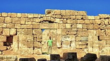
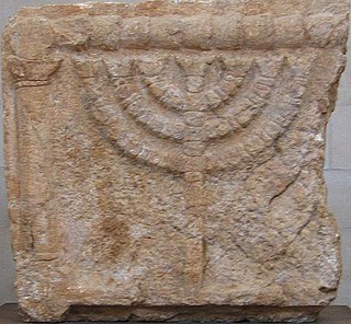
The Eshtemoa Synagogue, located 15 km south of Hebron in as-Samu, West Bank, refers to the remains of an ancient Jewish synagogue dating from around the 4th–5th century CE.
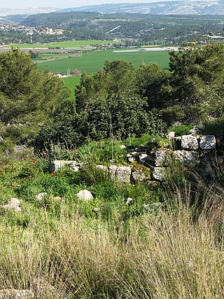
Anim Synagogue, a 25 km (16 mi) drive away northwest of Arad, was an ancient synagogue in use during the 4th–7th centuries CE. The site is recognized as a National Heritage Site of Israel. It is located in the Yatir Forest, immediately south of the Green Line, in Israel.
Ancient synagogues in Palestine refers to synagogues and their remains in the Palestine region, built by the Jewish and Samaritan communities from the time of the Hasmonean dynasty during the Late Hellenistic period, to the Late Byzantine period.

The Onomasticon compiled by Eusebius of Caesarea is a directory of place names, or "gazetteer", a primary source that provides historical geographers with a contemporary knowledge of early 4th-century Palestine and Transjordan. It sits uneasily between the ancient genres of geography and lexicography, taking elements from both but serving as a member of neither. It is, according to many, the most important book for the study of Palestine in the Roman period.
Kefar Shiḥlayim (Hebrew: כפר שחלים), a place name compounded of the word "Kefar" (village) plus a denominative, was a Jewish town in the Judean lowlands during the Second Temple period. The town is mentioned several times in Hebrew classical literature, viz., the Babylonian Talmud, the Jerusalem Talmud and in Midrash Rabba, and is thought to have been destroyed during the Bar Kochba revolt, alongside the villages of Bish and Dikrin, although later resettled.

Tell Maon was a biblical town in the Hebron Hills, formerly known simply as Maon, rising 863 metres (2,831 ft) above sea level. The town, now a ruin, is mentioned in the Book of Joshua (Joshua 15:55 and the Books of Samuel. It is located about 6 kilometres southeast of Yatta.