Carlisle is a cathedral city in the ceremonial county of Cumbria in England. It is the administrative centre of Cumberland Council which covers an area similar to the historic county of Cumberland.

The Ravenglass and Eskdale Railway is a 15 in minimum gauge heritage railway in Cumbria, England. The 7-mile (11.3 km) line runs from Ravenglass to Dalegarth Station near Boot in the valley of Eskdale, in the Lake District. At Ravenglass the line ends at Ravenglass railway station on the Cumbrian Coast Line.

Ravenglass is a coastal village in Cumberland, Cumbria, England. It is between Barrow-in-Furness and Whitehaven. Historically in Cumberland, it is the only coastal village in the Lake District National Park. It is located at the estuary of three rivers: the Esk, Mite and Irt.
Wasdale is a valley and civil parish in the western part of the Lake District National Park in Cumbria, England. The River Irt flows through the valley to its estuary at Ravenglass. A large part of the main valley floor is occupied by Wastwater, the deepest lake in England.

Hardknott Roman Fort is an archeological site, the remains of the Roman fort Mediobogdum, located on the western side of the Hardknott Pass in the English county of Cumbria. The fort was built between 120 and 138 on a rocky spur, and was initially garrisoned by a detachment of the Cohors IV Delmatarum from the Dalmatian coast. It was abandoned around a decade later, then reoccupied circa 200 and remained in use for much of the next two centuries.

Ravenglass is a railway station on the Cumbrian Coast Line, which runs between Carlisle and Barrow-in-Furness. The station, situated 29+1⁄4 miles (47 km) north-west of Barrow-in-Furness, serves the village of Ravenglass in Cumbria. It is owned by Network Rail and managed by Northern Trains.

Thwaites is a small village near Duddon Valley and on the edge of the Duddon Estuary in the Lake District National Park in the Borough of Copeland, Cumbria, England. The River Duddon flows through the valley, rising in the mountains between Eskdale and Langdale, before flowing into the Irish Sea near Broughton in Furness. In its lower reaches it is bounded by the Furness Fells and Harter Fell.

Boot is a small village in Eskdale, Cumbria, in the Lake District of England. It forms part of the Borough of Copeland.

Muncaster Fell is a fell at the far western edge of the Lake District National Park, in Cumbria, England. Muncaster Fell is a long, narrow ridge of land, approximately 1.2 km wide and 6 km long, lying between the River Mite to the north, and River Esk to the south. The fell rises from the coast near Ravenglass village to its highest point at Hooker Crag (231 m). The ridge then continues to the north-east, dropping gently to its furthest prominence at Silver Knott (174 m). The fell then falls away rapidly to the village of Eskdale Green at its north-eastern tip.

Irton Road railway station is a railway station on the 15 in gauge Ravenglass & Eskdale Railway in the Lake District National Park and the English county of Cumbria. The station is situated on the western edge of the village of Eskdale Green. It is some 4 miles (6.4 km) from Ravenglass and 3 miles (4.8 km) from Dalegarth for Boot, and trains take 20 minutes to reach their destinations in either direction from this station.

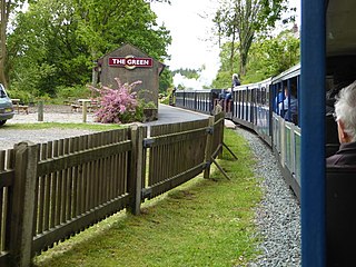
The Green is a railway station on the 15-inch gauge Ravenglass & Eskdale Railway in the Lake District National Park and the English county of Cumbria. The station is situated on the southern edge of the village of Eskdale Green, overlooking the Eskdale valley and Muncaster Fell. It was originally known as King of Prussia after the nearby public house, and later as Eskdale Green. The Eskdale Green name has continued in popular use, and was still in official use in 2017 in the railway's "full" timetable of intermediate stopping places.

Dalegarth railway station is the easterly terminus of the 15-inch gauge Ravenglass and Eskdale Railway in Cumbria, England. It has a café and shop for passengers, along with a run-round loop, turntable and siding for trains. It is located next to the Whillan Beck, a tributary of the River Esk flowing from the isolated Burnmoor Tarn.

Holmrook is a linear village in the English county of Cumbria. It lies along the A595 road on the west banks of the River Irt. The B5344 road connects it to Drigg, with its railway station less than two miles to the west.

St Catherine's Church is in the village of Boot, Cumbria, England. It is the Anglican parish church of Eskdale, Cumbria, and is in the deanery of Calder, the archdeaconry of West Cumberland, and the diocese of Carlisle. Its benefice is united with those of Irton, St Paul, Muncaster, St Michael, and St John, Waberthwaite. The church is recorded in the National Heritage List for England as a designated Grade II listed building. It stands by the side of the River Esk.

Irton Pike is a hill in the west of the English Lake District, near Santon Bridge, Cumbria. It is the subject of a chapter of Alfred Wainwright's book The Outlying Fells of Lakeland. The hill reaches a height of 751 feet (229 m). Wainwright's walk as described in Lakeland is an anticlockwise circuit from Irton Road station on the Ravenglass and Eskdale Railway, near Eskdale Green. He describes "this tiny top" as "a near-perfect solace for reminiscences of past happy days on the higher fells", adding "Climb Irton Pike while ye may!"

Irton with Santon is a civil parish in Copeland, Cumbria, England, which includes the village of Santon Bridge. It has a parish council. It had a population of 373 in 2001, decreasing to 316 at the 2011 Census.

Gate House or Gatehouse is a country house in Eskdale Green, Cumbria, England. The house became a Grade II listed building on 8 September 1967.

Giggle Alley is a woodland in Eskdale Green, Cumbria, England. It was formerly part of the Gate House estate. The wood includes the ruins of a Japanese garden, created in 1914 as part of the estate. It was laid out by the team of Thomas Hayton Mawson.

St Bega is in Eskdale, Cumbria, England. It is an active Anglican parish church in the deanery of Calder, and the diocese of Carlisle. Its benefice is Black Combe, Drigg, Eskdale, Irton, Muncaster and Waberthwaite. The church is not a listed building.

Muncaster is a civil parish in Cumbria, North West England. The parish is 41 miles (66 km) south west of the city of Carlisle, in the Copeland district, in the county of Cumbria, England. The parish includes the village of Ravenglass. In 2011 the parish had a population of 290. The parish touches Bootle, Drigg and Carleton, Eskdale, Irton with Santon, Ulpha and Waberthwaite.


