
Esparza is a town and municipality located in the province and autonomous community of Navarre, northern Spain.
Esparza is a town and municipality located in the province and autonomous community of Navarre, northern Spain.
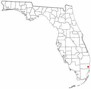
Broadview Park is a census-designated place (CDP) in Broward County, Florida, United States. The population was 7,670 at the 2020 census.
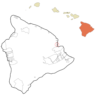
Paukaʻa is a census-designated place (CDP) in Hawaii County, Hawaii, United States. The population was 425 at the 2010 census, down from 495 at the 2000 census. The ZIP code is 96720.
Owasco is a town in Cayuga County, New York, United States. It is part of the traditional territory of the Cayuga nation. The population was 3,793 at the 2010 census. Owasco is in the eastern part of Cayuga County and is at the southeast city line of Auburn. The town borders Owasco Lake, from where it gets its name.
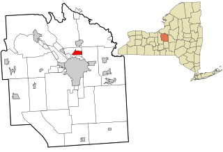
Mattydale is a hamlet in Onondaga County, New York, United States. The population was 6,446 at the 2010 census.

WNZK is a commercial AM radio station licensed to Dearborn Heights, Michigan, and serving the Detroit metropolitan area. It is owned by the Birach Broadcasting Corporation and airs an ethnic radio format. The programming is brokered, where hosts pay for their time and may advertise their clients' goods and services during their shows. It broadcasts in a variety of languages, including Arabic and several from Eastern Europe. WNZK identifies itself as "Station of the Nations."

Pleasant Hill Township is located in Pike County, Illinois. As of the 2010 census, its population was 1,259 and it contained 631 housing units.
XEFE-AM is a radio station in Nuevo Laredo, Tamaulipas, Mexico.

Brawdy is a village and community in Pembrokeshire, Wales.
Laurel is an unincorporated community in Whatcom County, Washington, United States. It lies between the cities of Bellingham and Lynden on State Route 539.

Bluie was the United States military code name for Greenland during World War II. It is remembered by the numbered sequence of base locations identified by the 1941 United States Coast Guard South Greenland Survey Expedition, and subsequently used in radio communications by airmen unfamiliar with pronunciation of the Greenlandic Inuit and Danish names of those locations. These were typically spoken BLUIE (direction) (number), with direction being east or west along the Greenland coast from Cape Farewell.

The Salazar Valley is a valley in the east of the Foral Community of Navarre in Spain. It lies within the Merindad of Zangoza-Sangüesa and within that, the Comarca of Roncal-Salazar. The Sierra de Abodi, part of the Western Pyrenees, forms the natural boundary in the north. There is a ski resort in Abodi.
Amarante, Piauí is a municipality in the state of Piauí in the Northeast region of Brazil.
Tidewater is an unincorporated community in Richmond County, in the U.S. state of Virginia.
Padež is a village in the municipality of Leskovac, Serbia. According to the 2002 census, the village has a population of 58 people.
The Fra Cristobal Range, is a 17 mi (27 km) long, mountain range in central-north Sierra County, New Mexico. Its northern extreme above Fra Cristoblal Mountain extends into Socorro County. The range borders the eastern shore of Elephant Butte Reservoir on the Rio Grande, and the range lies towards the southwest of the Jornada del Muerto, the desert region east of the river.

La Vera is a comarca in Extremadura, western Spain. The largest town is Jaraíz de la Vera.
The Church of St. Helena is a parish of the Roman Catholic Church in the Archdiocese of New York. Its parish church is located at the intersection of Olmstead Avenue and Benedict Avenue, Bronx, New York City, in the Unionport neighborhood. It was established in 1940, and the church building was built in the same year and was designed by the prominent architectural firm of Eggers & Higgins.

Flinn Springs is an unincorporated community in the East County region of San Diego County, California.

Wilcox Avenue is a major avenue of Los Angeles, running north–south through Hollywood, to the west of Cahuenga Boulevard. It begins to the north of Franklin Avenue from North Cahuenga Boulevard, and then runs south, crossing Sunset Boulevard, Santa Monica Boulevard and Melrose Avenue. The avenue grew primarily as an affluent residential road in the early 20th century, with the building of expensive luxury apartments. Silent actress Rosemary Theby once lived at 1907 Wilcox Avenue. The Mark Twain Hotel, a white stucco hotel named after writer Mark Twain, is located at 1622 Wilcox and was recently (2016) restored and converted into a boutique inn. There are several bars and restaurants including Paladar, a Cuban restaurant and bar at 1651 Wilcox Avenue, and The Nacional, a Havana-style cocktail bar next door at 1645. 1626 North Wilcox Avenue is the location of a company known as Hollywood Mail which rents hundreds of physical addresses for those who wish to make it appear that their business is actually located at that address.
Fra Cristoblal Mountain is the highest summit of the Fra Cristobal Range in Sierra County, New Mexico. It is the peak in the northern end of the range, which gives the range its name. It rises to an elevation of 5,932 feet (1,808 m). The summit overlooks the Jornada del Muerto to the east.
| International | |
|---|---|
| Geographic | |
| Other | |
42°51′18″N1°05′55″W / 42.85500°N 1.09861°W
| | This article about a location in Navarre, Spain, is a stub. You can help Wikipedia by expanding it. |