Essex Road is a main road in Islington, London. It is part of the A104 and connects Islington High Street with Balls Pond Road via Essex Road railway station.

Essex Road is a main road in Islington, London. It is part of the A104 and connects Islington High Street with Balls Pond Road via Essex Road railway station.
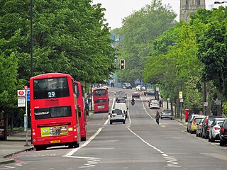
The road is about 1 mile (1.6 km) long. It starts as continuation of Islington Green, which is a fork from Islington High Street, and runs northeastwards over New North Road towards Balls Pond Road. It is part of the A104, a main local road across northeast London. [1]

The northern section of the road was once called Seveney Street, possibility indicating a Roman connection. [2] The southern section was called Lower Street, as it was a lower ground level than Upper Street. Many properties along the road were constructed in the 18th and early 19th centuries. Most of these are still standing, though the various inns alongside them have been redeveloped. [3]
Islington Market was founded in 1836 by John Perkins on a 15 acres (6.1 ha) site to the east of Essex Road and north of what is now Northchurch Road. It was not successful, and the site lay derelict for some years. After the Caledonian Market was established elsewhere in Islington, the old market area was laid out with new streets. [4]
The New River crossed Essex Road where it met Colebrooke Row in a 45 metres (148 ft) tunnel. The river was piped in 1861. [3]

Fisher House stood at the junction of Essex Road and Cross Street. It was constructed in the 17th century as a residential mansion. It later became an asylum before being demolished in 1845. [3]
The Old Queen's Head, a pub, contains a plaster ceiling and chimneypiece constructed in the 16th century. [3]

The Lower Street Meeting House was founded in 1744 at what is now the junction of Essex Road and Greenman Street. It was the first Dissenter chapel to be constructed in Islington. It subsequently became The Green Man, a pub. [3]
Samuel Ridley's floorcloth factory was built in 1812 on what was open fields around the north end of Essex Road. It became Probyn's bottling factory in 1893, and was later redeveloped as council offices in the 1970s. [5]
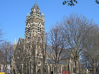
The South Library is on the corner of Essex Road and Cross Street. [6] It was constructed in 1916 in a Queen Anne style. [3]
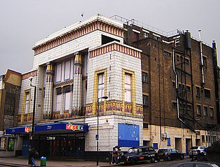
The Carlton Cinema was at Nos. 161-169. It was built in 1930 in an art deco style by George Coles, using an Egyptian style facade. It was subsequently used as a bingo hall, and then a place of worship. The building is Grade II* listed. [7]
Essex Road railway station is halfway along the road. It opened on 14 February 1904 as part of the Great Northern & City Railway from Moorgate to Finsbury Park. [8] Services are operated by Great Northern. [9]

Charing Cross Road is a street in central London running immediately north of St Martin-in-the-Fields to St Giles Circus, which then merges into Tottenham Court Road. It leads from the north in the direction of Charing Cross at the south side of Trafalgar Square. It connects via St Martin's Place and the motorised east side of the square.

Dalston is an area of East London, in the London Borough of Hackney. It is four miles northeast of Charing Cross. Dalston began as a hamlet on either side of Dalston Lane, and as the area urbanised the term also came to apply to surrounding areas including Kingsland and Shacklewell, all three of which being part of the Ancient Parish of Hackney.

Islington is a district in the north of Greater London, England, and part of the London Borough of Islington. It is a mainly residential district of Inner London, extending from Islington's High Street to Highbury Fields, encompassing the area around the busy High Street, Upper Street, Essex Road, and Southgate Road to the east.

St Giles Circus is a road junction in the St Giles district of the West End of London at the eastern end of Oxford Street, where it connects with New Oxford Street, Charing Cross Road and Tottenham Court Road, which it is more often referred to owing to the location of Tottenham Court Road Underground station directly under the junction. It is near to Soho, Covent Garden, Bloomsbury and Fitzrovia.

Euston Road is a road in Central London that runs from Marylebone Road to King's Cross. The route is part of the London Inner Ring Road and forms part of the London congestion charge zone boundary. It is named after Euston Hall, the family seat of the Dukes of Grafton, who had become major property owners in the area during the mid-19th century.

Strand is a major thoroughfare in the City of Westminster, Central London. The street, which is part of London's West End theatreland, runs just over 3⁄4 mile (1.2 km) from Trafalgar Square eastwards to Temple Bar, where the road becomes Fleet Street in the City of London, and is part of the A4, a main road running west from inner London.

Farringdon Road is a road in Clerkenwell, London.

The Angel, Islington, is a historic landmark and a series of buildings that have stood on the corner of Islington High Street and Pentonville Road in Islington, London, England. The land originally belonged to the Clerkenwell Priory and has had various properties built on it since the 16th century. An inn on the site was called the "Angel Inn" by 1614, and the crossing became generally known as "the Angel". The site was bisected by the New Road, which opened in 1756, and properties on the site have been rebuilt several times up to the 20th century. The corner site gave its name to Angel tube station, opened in 1901, and the surrounding Angel area of London.

Burnt Oak is a suburb of London, England, located 9 miles (14 km) northwest of Charing Cross. It lies to the west of the M1 motorway between Edgware and Colindale, located predominantly in the London Borough of Barnet, with parts in the London Boroughs of Brent and Harrow. It was part of Middlesex until it was transferred to Greater London in 1965.

Upper Street is the main street of the Islington district of inner north London, and carries the A1 road. It begins at the junction of the A1 and Liverpool Road, continuing on from Islington High Street which runs from the crossroads at Pentonville Road/City Road and runs roughly northwards from outside the main entrance to Angel Underground station, then past the Business Design Centre, then splits at Islington Green, then past The Screen On The Green cinema, past Islington Town Hall, ending at Highbury & Islington tube station on Highbury corner, where the A1 carries on as Holloway Road.

The Metropolitan Cattle Market, just off the Caledonian Road in the parish of Islington was built by the City of London Corporation and was opened in June 1855 by Prince Albert. The market was supplementary to the meat market at Smithfield and was established to remove the difficulty of managing live cattle at that latter site.

The A104 is an A road which runs from Islington Green in London to Epping in Essex, England.

Caledonian Road passes for about a mile and a half north–south through the London Borough of Islington. It connects North London, from Camden Road near its junction with Holloway Road, and central London's Pentonville Road in the south. It is known colloquially as the "Cally" and forms the entirety of the A5203.

Camden Road is a main road in London running from the junction of Camden High Street and Camden Town Underground station up to Holloway Road. It is part of the A503 which continues east as Tollington Road.

The Angel is an area on the northern fringes of Central London within the London Borough of Islington. It is 2 miles (3.2 km) north-northeast of Charing Cross on the Inner Ring Road at a busy transport intersection. The area is identified in the London Plan as one of 35 major centres in London. It is a significant commercial and retail centre, and a business improvement district. The Angel straddles the ancient boundary of the parishes of Clerkenwell and Islington that later became the metropolitan boroughs of Finsbury and Islington. It is named from the former Angel Inn which stood on the corner of Islington High Street and Pentonville Road. Since 1965 the whole area has formed part of the London Borough of Islington in Greater London.

The Cheshire Cheese is a public house at 5 Little Essex Street, London WC2, on the corner with Milford Lane.

The Edgar Wallace is a public house at 40–41 Essex Street, London WC2, at the corner with Devereux Court.

Cranbourn Street is a street in Central London. It connects Leicester Square to Long Acre via Charing Cross Road.

Angel Recording Studios Limited was a British recording studio based in the eponymous recording and mixing complex in Islington, London. The company was incorporated by James Warren Sylvester de Wolfe on 5 December 1978. After ownership of the property transferred to third parties, the facility was closed at the end of 2019.

The former Carlton Cinema is an Art deco Grade II* listed building, located at 161–169 Essex Road, Islington, London. It was completed in 1930 as a cine-variety theatre with a capacity of 2,226 seats.
Citations
Sources