Estuary of St. Lawrence

Last updated
St. Lawrence Estuary
Estuaire du Saint-Laurent (in French)
Estuaire du Saint-Laurent, couleurs matinales (Matthieu Gauvain).JPG
Maritime section at Port-au-Saumon
Canada Quebec relief location map.jpg
Red pog.svg
Canada relief map 2.svg
Red pog.svg
Etymology Saint Lawrence of Rome
Location
Country Canada
Province Quebec
Physical characteristics
Source Saint Lawrence River
  location Lake Saint-Pierre, Trois-Rivières
  coordinates 46°16′17″N72°38′5″W / 46.27139°N 72.63472°W / 46.27139; -72.63472
Mouth Gulf of St. Lawrence / Atlantic Ocean
  location
Pointe des Monts
  coordinates
49°08′N67°14′W / 49.133°N 67.233°W / 49.133; -67.233
  elevation
0 m (0 ft)
Discharge 
  locationbelow the Saint Lawrence River

St. Lawrence Estuary stretches from west to east for 655 km, from the outlet of Lake Saint Pierre to pointe des Monts, [1] where it becomes the Gulf of St. Lawrence, in Quebec, Canada.

Contents

The estuary is divided into 3 parts, the fluvial estuary, the middle estuary and the maritime estuary. [1] [2] The waters coming from the north shore of the St. Lawrence and Labrador come mainly from the Canadian Shield. [3]

Among the deepest and largest estuaries in the world, the St. Lawrence maritime estuary extends nearly 250 km before it widens at Point-des-Monts into the Gulf of St. Lawrence. This enclosed sea is connected to the Atlantic Ocean by Cabot Strait and the Strait of Belle-Isle.

Birch bark canoe, Ilnu Museum in Mashteuiatsh, Saguenay-Lac-Saint-Jean Mashteuiatsh 004.jpg
Birch bark canoe, Ilnu Museum in Mashteuiatsh, Saguenay–Lac-Saint-Jean

The culture of the First Nations in Canada was largely based on birch, and the Birch bark canoe provided these hunting peoples with the mobility essential to this way of life. [5] [6]

After crossing the Gulf of St. Lawrence, the itinerary of the first Europeans: whalers, fishermen, explorers and navigators enters the waters of the Estuary, where the most difficult manoeuvres of the voyage begin: reefs, shoals, diagonal currents, fog and the presence of shallow channels, often narrow and winding, not to mention winter and ice and its unpredictable and fearsome storms. Throughout its history, the estuary or St. Lawrence River is not easily domesticated. [7]

St. Lawrence Pilots

Grandes Eaux, pilot vessels at their homeport, Anse aux Basques, Les Escoumins Les Escoumins 043.jpg
Grandes Eaux, pilot vessels at their homeport, Anse aux Basques, Les Escoumins

From Les Escoumins [8] to the Great Lakes, St. Lawrence maritime pilots experts in navigating specific sectors of the River [9] ensure the safe efficient passage of the vessels under their care.

Fluvial estuary

Lake Saint-Pierre, lighthouse, shoreline, Pointe-du-Lac Pointe du Lac 002.jpg
Lake Saint-Pierre, lighthouse, shoreline, Pointe-du-Lac

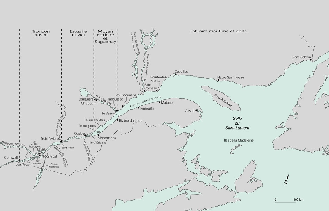
Running for about 160 km, the fluvial estuary or estuarine section of the river extends from the outlet of lake Saint-Pierre [10] [11] to the RCM L'Islet; the portion of the river under the power of freshwater tides.

The average depth of the main channel varies from 13 to 40 m, with pools of 21 m in Trois-Rivières-Ouest and 60 m in Quebec City. [2]

Starting with lake Saint-Pierre, the ecological conditions of the St. Lawrence underwent a radical change. The slow and continuous advance of the great mass of fresh water gradually gives way to the regime of the upflow tide, where twice every twenty-four hours the shores undergo a short alternation of emersion and immersion. [12]

The waters of the streams and rivers that flow into the river differ from those of the St. Lawrence in terms of temperature, chemical composition and suspended solids. The main rivers of the fluvial estuary, on the south shore, are the Bécancour, Chaudière, Rivière du Sud rivers, on the north shore: St. Maurice Champlain, Batiscan, Sainte-Anne, Jacques-Cartier, Saint-Charles, Montmorency rivers and several secondary watercourses.

The waters retain their distinctiveness over a relatively long course before mixing. Those in the Rivière des Outaouais keep their properties up to 25 km downstream from the mouth of the Saint-Maurice. Downstream of Grondines, the currents of the rising tide (flood) reverse the direction of the river's flow. The result is an increasingly homogeneous stirring and mixing of fresh water from different sources. [2]

Flora

Extends along seven kilometres of shoreline in the St. Lawrence River's fluvial estuary, the Grondines and Sainte-Anne-de-la-Pérade swamp is one of the last, large, treed swamps on the river. [13]

Between Saint-Augustin-de-Desmaures and Île aux Grues, from 2008 to 2012, three plants characteristic of the St. Lawrence freshwater estuary and in a precarious situation were monitored annually: Victorin's gentian (Gentianopsis virgata ssp. victorinii), Victorin's water-hemlock (Cicuta maculata var. victorinii) and Parker's Buckwheat (Eriocaulon parkeri). [14]

Middle estuary

Passage of couriers from Transat Quebec Saint-Malo, Saint-Laurent-de-l'Ile-d'Orleans 2000 000730 15aa.jpg
Passage of couriers from Transat Quebec Saint-Malo, Saint-Laurent-de-l'Île-d'Orléans 2000

Running for about 195 km, the middle estuary of the St. Lawrence extends, according to the authors, from the eastern tip of Île d'Orléans [16] or Saint-Jean-Port-Joli, to the mouth of the Saguenay River. This estuary section widens rapidly from a few kilometres to 10 km, then to 20 km upstream of Île aux Coudres and the archipelago of L'Isle-aux-Grues. [2]

The middle estuary is mainly characterized by the mixing of freshwater-influenced waters with salt water and high turbidity (turbid water). The hydrodynamic conditions, mainly the reversal of tidal currents and the increase in the salinity gradient, are such that a large amount of suspended solids is trapped and forms a muddy plug (turbidity zone). At ebb tide, the average water flow reaches 90,000 m3/s (fresh and salt water) in Montmagny. [2]

Geomorphology

Over the millennia, several geomorphological events have shaped the landscape of the territory on the south shore of the middle estuary.

The tectonic movements responsible for the genesis of the Appalachian Mountains explain the nature and configuration of the bedrock. Ice and interglacial periods led to glaciations, melts, and marine invasions, ice movements level the Appalachian Mountains. The large layers of sediment in the territory are the legacy of tectonic movements combined whit glacial and interglacial periods. [17]

Maritime estuary

Saguenay-St. Lawrence Marine Park, Maritime estuary of St. Lawrence River, Tadoussac Peche oursins verts 009.jpg
Saguenay–St. Lawrence Marine Park, Maritime estuary of St. Lawrence River, Tadoussac

Among the deepest and largest estuaries in the world, running for about 300 km, the maritime Estuary of the St. Lawrence extends from the mouth of Saguenay River at Tadoussac to Pointe-des-Monts where the Gulf begins.

The Whale Route

Along the shore, the Whale Route [18] (Route 138), stretches from Tadoussac to Labrador, the National road is one of the best places in the worl to observe marine mammals. There, the two bodies of water that mix off the coast of Tadoussac give the Maritime Estuary characteristics that distinguish it from other reaches of the St. Lawrence: nutrient-rich surface waters throughout the summer and upwellings of deep, cold water that favour the formation of Euphausiids. -Krill. Those organisms rise towards the surface near the shore, providing vast food stores for whales as large Baleen whales [19] , as many others variety of whales and seals. It is home to the southernmost Beluga whale population in the world. [20] [21]

This section is connected to the Gulf of St. Lawrence, an enclosed sea leading to the Atlantic Ocean by Cabot Strait and the Strait of Belle-Isle. [22]

Fauna and flora

Habitats

The zone of contact between fresh and salt water corresponds to a region of high concentrations of suspended matter causing a zone of maximum turbidity (MTZ) of a length that can vary from 70 to 120 kilometres (43 to 75 mi), depending on the flow of the river. [23] This zone of maximum turbidity is located between Île d'Orléans (salinity greater than 0 PSU) and Île aux Coudres (salinity below 10 PSU). The mechanisms of estuarine circulation associated with this environment make it a privileged site of primary and secondary production which shelters many fish nurseries. High environmental turbidity provides shelter against predators while larvae are maintained under optimum temperature and salinity conditions. [24] [25] [26] Large variations in salinity and turbidity result in a wide variety of physicochemical conditions and planktonic communities on the river.

An emblematic species is the beluga (beluga whale), but many other species are present. An identification guide for marine fishes of the estuary and northern Gulf of St. Lawrence was completed in 2008. [27]

See also

Related Research Articles

<span class="mw-page-title-main">St. Lawrence River</span> Major river in eastern Canada and the United States, flowing into the Gulf of St. Lawrence

The St. Lawrence River is a large international river in the middle latitudes of North America connecting the Great Lakes to the North Atlantic Ocean. Its waters flow in a northeasterly direction from Lake Ontario to the Gulf of St. Lawrence, traversing Ontario and Quebec in Canada and New York in the United States. A section of the river demarcates the Canada–U.S. border.

<span class="mw-page-title-main">Gulf of St. Lawrence</span> Outlet of the North American Great Lakes via the St. Lawrence River into the Atlantic Ocean

The Gulf of St. Lawrence fringes the shores of the provinces of Quebec, New Brunswick, Nova Scotia, Prince Edward Island, Newfoundland and Labrador, in Canada, plus the islands Saint-Pierre and Miquelon, possessions of France, in North America.

<span class="mw-page-title-main">Île d'Orléans</span> Island in the Saint Lawrence River, Quebec, Canada

Île d'Orléans is an island located in the Saint Lawrence River about 5 kilometres (3.1 mi) east of downtown Quebec City, Quebec, Canada. It was one of the first parts of the province to be colonized by the French, and a large percentage of French Canadians can trace ancestry to early residents of the island. The island has been described as the "microcosm of traditional Quebec and as the birthplace of francophones in North America."

<span class="mw-page-title-main">Chaleur Bay</span> Arm of the Gulf of Saint Lawrence between Quebec and New Brunswick, Canada

Chaleur Bay, also Chaleurs Bay, Bay of Chaleur, is an arm of the Gulf of Saint Lawrence located between Quebec and New Brunswick, Canada.

<span class="mw-page-title-main">Bas-Saint-Laurent</span> Administrative region in Quebec, Canada

The Bas-Saint-Laurent, is an administrative region of Quebec located along the south shore of the lower Saint Lawrence River in Quebec. The river widens at this place, later becoming a bay that discharges into the Atlantic Ocean and is often nicknamed "Bas-du-Fleuve" (Lower-River). The region is formed by eight regional county municipalities and 114 municipalities. In the south, it borders Maine of the United States, and the Canadian New Brunswick and the regions of Chaudière-Appalaches and Gaspésie–Îles-de-la-Madeleine.

<span class="mw-page-title-main">Magdalen Islands</span> Archipelago of Quebec, Canada

The Îles de la Madeleine are an archipelago in the Gulf of St. Lawrence. These 12 islands make up the Les Îles-de-la-Madeleine municipality, in the Gaspésie-Îles-de-la-Madeleine region, Quebec, Canada.

<span class="mw-page-title-main">Saguenay River</span> Major tributary of the St. Lawrence River in Quebec, Canada

The Saguenay River is a major river of Quebec, Canada. It drains Lac Saint-Jean in the Laurentian Highlands, leaving at Alma and running east; the city of Saguenay is located on the river. It drains into the Saint Lawrence River. Tadoussac, founded as a French colonial trading post in 1600, is located on the northeast bank at this site.

<span class="mw-page-title-main">Saguenay–St. Lawrence Marine Park</span> National marine conservation area in Quebec, Canada

The Saguenay–St. Lawrence Marine Park is a National Marine Conservation Area, one of three in the Canadian national park system, located where the Saguenay River meets the Maritime estuary of the St. Lawrence River. This park is jointly managed by Parks Canada and Sépaq. It is the first park in all of Canada to protect a purely marine environment, and covers a surface area of 1,245 km2. The area that is now the Saguenay–St. Lawrence Marine Park is a part of the Innue Essipit First Nation's land claim, and a treaty resulting from this claim could impact activities that are practiced within the park. The region surrounding the park is an important part of the history of Canada, being one of the first points of contact between Indigenous Peoples and European explorers and the birthplace of the intercontinental fur trade.

<span class="mw-page-title-main">Geography of Quebec</span>

Located in the eastern part of Canada, and part of Central Canada, Quebec occupies a territory nearly three times the size of France or Texas. It is much closer to the size of Alaska. As is the case with Alaska, most of the land in Quebec is very sparsely populated. Its topography is very different from one region to another due to the varying composition of the ground, the climate, and the proximity to water. The Great Lakes–St. Lawrence Lowlands and the Appalachians are the two main topographic regions in southern Quebec, while the Canadian Shield occupies most of central and northern Quebec.

<span class="mw-page-title-main">Tadoussac</span> Village in Quebec, Canada

Tadoussac is a village municipality in La Haute-Côte-Nord RCM, on the north shore of the maritime section of the estuary of St. Lawrence river, in Côte-Nord region, Quebec, Canada.

<span class="mw-page-title-main">Rivière du Loup (Bas-Saint-Laurent)</span> River in Quebec, Canada

The Rivière du Loup is a river in eastern Quebec, Canada, which empties on the south shore of Saint Lawrence River at the city of Rivière-du-Loup, which is part of the regional county municipality (RCM) Rivière-du-Loup, in the administrative region of Bas-Saint-Laurent.

<span class="mw-page-title-main">Quebec Route 138</span> Highway in Quebec

Route 138 is a major highway in the Canadian province of Quebec, following the entire north shore of the Saint Lawrence River past Montreal to the temporary eastern terminus in Kegashka on the Gulf of Saint Lawrence. The western terminus is in Elgin, at the border with New York State south-west of Montreal. Part of this highway is known as the Chemin du Roy, or King's Highway, which is one of the oldest highways in Canada.

<span class="mw-page-title-main">Baie-Trinité, Quebec</span> Village municipality in Quebec, Canada

Baie-Trinité is part of the Manicouagan Regional County Municipality, in Côte-Nord region, Quebec province, Canada.

<span class="mw-page-title-main">Mingan Archipelago National Park Reserve</span> National park reserve in Quebec, Canada

Mingan Archipelago National Park Reserve or Mingan Archipelago Heritage Site bathes in the waters of the Gulf of St. Lawrence, in the administrative region of Côte-Nord, in the municipality of Havre-Saint -Pierre, facing Anticosti Island.

<span class="mw-page-title-main">Les Escoumins</span> Municipality in Quebec, Canada

Les Escoumins is a municipality in La Haute-Côte-Nord Regional County Municipality in the Côte-Nord region of Quebec. It is located on the north shore of the maritime estuary of the St. Lawrence River.

<span class="mw-page-title-main">Havre-Saint-Pierre</span> Municipality in Quebec, Canada

Havre-Saint-Pierre is a Municipality located on the north shore of the Gulf of St. Lawrence, in Côte-Nord region, Minganie Regional County, Quebec, Canada.

<span class="mw-page-title-main">Tourism in Quebec</span>

Tourism is the fifth-largest industry in Quebec. Some 29,000 companies are involved in the industry, generating 130,000 direct and 48,000 indirect jobs. In 2006, Quebec welcomed 3.2 million foreign tourists, most of them from the United States, France, the United Kingdom, Germany, Mexico and Japan. Quebec's French heritage sets the province apart from the most of Canada and the United States, as well as Mexico. The province has preserved its Francophone culture with a European feel.

<span class="mw-page-title-main">Sainte-Anne-des-Monts</span> City in Quebec, Canada

Sainte-Anne-des-Monts, is a city in La-Haute-Gaspésie Regional County Municipality, Gaspésie–Îles-de-la-Madeleine region, Quebec province, in Canada.

Bic National Park is an 33.2-square-kilometre (8,200-acre) national park of Quebec, Canada, located on the south shore of the St. Lawrence River, near the villages of Le Bic and Saint-Fabien, southwest of Rimouski. It was founded on October 17, 1984, and is home to large populations of harbour seals and grey seals. Its highest point is Pic Champlain at 346 metres (1,135 ft). Slightly less than half of the park is a coastal marine environment.

<span class="mw-page-title-main">Saguenay Fjord National Park</span> Provincial park in Quebec, Canada

Saguenay Fjord National Park is a provincial park located in Quebec, Canada. In the regions of Saguenay–Lac-Saint-Jean, Charlevoix, Côte-Nord, and Bas-Saint-Laurent, the park is situated along the eastern end of the Saguenay River and adjoins the Saguenay–St. Lawrence Marine Park for over 100 km (60 mi.).

References

  1. 1 2 "Pointe des Monts". Toponymy Quebec Commission (in French). Government of Quebec. 1968-12-05. Retrieved 20 February 2024. The coastline of Pointe des Monts on the North Shore and the city of Matane, opposite, in the Gaspé Peninsula, are the points that serve as the boundary between the estuary of the St. Lawrence River upstream, and the much wider Gulf of St. Lawrence, downstream.
  2. 1 2 3 4 5 "A river, estuaries, a gulf, the great hydrographic divisions" (PDF). Atlas of the St. Lawrence (in French). Atlas environnemental du Saint-Laurent. 1991. Retrieved 11 April 2024. The width of the Lower Estuary varies from 24 km to Tadoussac 50 km to Pointe-des-Monts
  3. Historica Canada (2024). "Great Lakes-St. Lawrence Watershed" (in English and French). Canadian Encyclopedia. Retrieved 18 April 2024. The one million square kilometre region includes the Canadian portion of the watersheds of rivers that flow into the St. Lawrence River from east of Montreal, into the Gulf of St. Lawrence and into the Atlantic Ocean.
  4. "Amerindian Museum of Mashteuiat". 2024. Retrieved 21 April 2024. Our team is composed of members from the Pekuakamiulnuatsh First Nation
  5. Frère Marie-Victorin (1935). "The birch bark canoe, an exceptional reign". florelaurentienne.com (in French). florelaurentienne.com. pp. 150 of 925. Retrieved 21 April 2024. Betula papyrifera Marshall. — Bouleau à papier. — Bouleau blanc, Bouleau à canot. — (Canoë birch).
  6. "Bark Canoe Construction". Canadian Museum of History. Government of Canada. Retrieved 21 April 2024. In Canada, the most popular bark for canoe construction has come from the paper birch
  7. Alain Franck (2000-11-02). "Navigation on the St. Lawrence River" (PDF). La Fédération des sociétés d'histoire du Québec, 2000 (in French). Histoire Québec. p. 6. Retrieved 19 April 2024. The river, which the Amerindians had called "the walking way," was the only communication and transportation route for the pioneers.
  8. 1 2 "Anse aux Basques". Quebec Gouvernement (in French). Commission de Toponymie Quebec. 1968-12-05. Retrieved 9 May 2024. The pilot station of the Corporation des pilotes du Bas-Saint-Laurent occupies the northern part of the cove, a 61-metre-long wharf that allows boarding the pilot boat.
  9. "Marine Pilot, main tasks and duties" (PDF). 2015-07-29. Retrieved 26 April 2024. Interest in working at sea, Excellent spatial perception, Ability to work in crisis situations and under unforeseen circumstances,
  10. "0303-carte.jpg". Sustainable development, Environment and Park. Retrieved 27 November 2008.
  11. Manon Couture (21 October 2010). "Portrait and diagnosis of the Orphan Basin Zone of southern Lake Saint-Pierre" (PDF) (in French). Organisme de concertation pour l’eau des bassins versants de la rivière Nicolet (Copernic). pp. 14 of 75. The effect of the tides is faintly perceptible in Lake Saint-Pierre, the last freshwater basin before the estuary
  12. Frère Marie-Victorin (1935). "St. Lawrence Estuarine Section". florelaurentienne.com (in French). pp. 53, 54. Retrieved 12 April 2024. The estuarine section is the portion of the river under the power of freshwater tides
  13. "The Grondines and Sainte-Anne-de-la-Pérade Swamp". Nature Conservancy of Canada. Retrieved 18 April 2024. The diversity and number of birds that frequent the area's agricultural, forest and coastal lands are impressive — more than 100 bird species have been recorded in the area.
  14. Hélène Gilbert (2013). "Monitoring of 3 rare plants from the St. Lawrence freshwater estuary" (PDF). Le Naturaliste canadien (in French). La Société Provancher d'histoire naturelle du Canada. p. 10. Retrieved 14 April 2024. Monitoring was carried out between Saint-Augustin-de-Desmaures and Île aux Grues, at 10 sites where at least one of these taxa was present.
  15. Kate Jennings (19 July 2008). "A four part course between Quebec and Saint Malo". Sail-World. Retrieved 22 April 2024. The immense Saint Lawrence estuary emerges on the second part of the course, a veritable anti-chamber prior to the open ocean and the Atlantic.
  16. Jean Poirier (1962). "The toponymy of Île d'Orléans" (PDF). Erudy (in English and French). Cahiers de géographie du Québec. pp. 2 of 19. Retrieved 21 April 2024. Île d'Orléans is located in the upper estuary of the St. Lawrence River, three miles downstream from the city of Quebec
  17. "A coastal landscape with history!" (PDF). Conseil du Saint-Laurent (in French). Regional Consultation Table (TCR) of the South of the Middle Estuary. 2019-01-17. pp. 3 of 11. Retrieved 16 April 2024. Study several geomorphological events have shaped the landscape of the territory
  18. "Network of observation sites along the Whale Route (Route 138)" (PDF). 2010-05-21. p. 12. Retrieved 11 May 2024. Whale-watching sites for everyone
  19. "Whales of the St. Lawrence river". Whales Online. 2024. Retrieved 18 April 2024. The estuary is home to belugas all year round. In summer, the estuary also hosts rorquals and other species of toothed whales that benefit from the abundance of krill, capelin and other small fish.
  20. "The Beluga Whale" (PDF). Fisheries and Oceans Canada. 2010-03-21. Retrieved 18 April 2024. The beluga whale frequents different habitats depending on the season and progression of ice breakup and freeze.
  21. "Saguenay–St Lawrence Marine Park Management Plan 2010". Government of Canada. 2020-12-09. Retrieved 18 April 2024. The abundance of food in the Marine Park's ecosystems attracts many species of birds, whales and seals.
  22. "The Estuary and the Gulf of St. Lawrence". Fischeries and Oceans Canada. Government of Canada. 2023-08-01. Retrieved 25 April 2024. Among the deepest and largest estuaries in the world
  23. Silverberg, Norman; Sundby, Bjørn (1979-04-01). "Observations in the turbidity maximum of the St. Lawrence Estuary". Canadian Journal of Earth Sciences. 16 (4): 939–950. doi:10.1139/e79-080. ISSN   0008-4077.
  24. Sirois, P; Dodson, Jj (2000). "Critical periods and growth-dependent survival of larvae of an estuarine fish, the rainbow smelt Osmerus mordax". Marine Ecology Progress Series. 203: 233–245. doi: 10.3354/meps203233 . ISSN   0171-8630.
  25. North, E. W.; Houde, E. D. (October 2001). "Retention of White Perch and Striped Bass Larvae: Biological-Physical Interactions in Chesapeake Bay Estuarine Turbidity Maximum". Estuaries. 24 (5): 756. doi:10.2307/1352883. JSTOR   1352883. S2CID   32886478.
  26. Winkler, G; Dodson, Jj; Bertrand, N; Thivierge, D; Vincent, Wf (2003). "Trophic coupling across the St. Lawrence River estuarine transition zone". Marine Ecology Progress Series. 251: 59–73. doi: 10.3354/meps251059 . ISSN   0171-8630.
  27. C. Nozères; D. Archambault; P.-M. Chouinard; J. Gauthier; R. Miller; E. Parent; P. Schwab; L. Savard; J.-D. Dutil (2010). "Identification guide for marine fishes of the estuary and northern Gulf of St. Lawrence and sampling protocols used during trawl surveys between 2004 and 2008" (PDF) (in English and French). Regional Science Branch Fisheries and Oceans Canada, Maurice Lamontagne Institute. Retrieved 8 April 2024. Important source of information on the status of marine resources harvested in the estuary and northern Gulf of St. Lawrence.
  1. "Corporation of Pilots of the Lower St. Lawrence" . Retrieved 25 April 2024. The expert training, precise knowledge and practical experience required of pilots are therefore indispensable for navigating this river.