
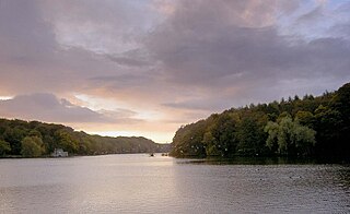
Etherow Country Park is in Compstall, a village between Marple Bridge and Romiley, in the Metropolitan Borough of Stockport, Greater Manchester, England. It is a Local Nature Reserve [1] [2] and the starting point of the Goyt Way. [3]
Etherow Country Park is in Compstall, a village between Marple Bridge and Romiley, in the Metropolitan Borough of Stockport, Greater Manchester, England. It is a Local Nature Reserve [1] [2] and the starting point of the Goyt Way. [3]
Etherow was one of England's first country parks. Originally it was an industrial area incorporating a mine, a mill and a mill pond. The River Etherow flows through the park and is the source for the mill pond. With the decline of industry, the mill pond and park have become a nature reserve and a place for people to spend time walking and taking in the peaceful surroundings.

Compstall Nature Reserve is a 12.8-hectare (32-acre) region of the park which was designated a Site of Special Scientific Interest (SSSI) in 1977; this was for its biological interest, especially its wide range of habitats including open water, tall fen, reed swamp, carr and mixed deciduous woodland.
The site is also of considerable ornithological interest with water rail, an uncommon species, having been recorded. [4] [5]
Etherow Country Park has many local groups associated with it:
Newmillerdam is a village and suburb of Wakefield, in West Yorkshire, England. The name refers to the lake and country park adjacent to the village. The park is a local nature reserve.

The River Etherow in northern England is a tributary of the River Goyt. Although now passing through South Yorkshire, Derbyshire and Greater Manchester, it historically formed the ancient county boundary between Cheshire and Derbyshire. The upper valley is known as Longdendale. The river has a watershed of approximately 30 square miles (78 km2), and the area an annual rainfall of 52.5 inches (1,330 mm).

The River Mersey is a major river in North West England. Its name derives from Old English and means "boundary river", possibly referring to its having been a border between the ancient kingdoms of Mercia and Northumbria. For centuries it has formed part of the boundary between the historic counties of Lancashire and Cheshire.

The Upper Goyt Valley is the southern section of the valley of the River Goyt in North West England.

Compstall is a village in the Metropolitan Borough of Stockport, Greater Manchester, England, between Marple Bridge and Romiley. Historically part of Cheshire, it was formerly a mill village built by George Andrew in the 1820s to house his 800 workers; most of the original mill cottages and other structures remain unchanged.

London Wildlife Trust (LWT), founded in 1981, is a local nature conservation charity for Greater London. It is one of 46 members of the Royal Society of Wildlife Trusts, each of which is a local nature conservation charity for its area. The Trust aims to protect London's wildlife and wild spaces, and it manages 36 nature reserves in Greater London. The Trust provides education services for schools. Local groups work on reserves and organise walks.

Ingrebourne Marshes are a 74.8 hectare biological Site of Special Scientific Interest in Hornchurch in the London Borough of Havering. Ingrebourne Valley Local Nature Reserve includes a small part of the SSSI west of the River Ingrebourne.

Hedgecourt is a 33.6-hectare (83-acre) biological Site of Special Scientific Interest (SSSI) north of Felbridge in Surrey. An area of 5 ha is managed by the Surrey Wildlife Trust.

Kings and Bakers Woods and Heaths is a 212.8-hectare (526-acre) Site of Special Scientific Interest (SSSI) between Heath and Reach in Bedfordshire and Great Brickhill in Buckinghamshire. The site is mainly in Bedfordshire but includes Rammamere Heath in Buckinghamshire. It was notified in 1984 under Section 28 of the Wildlife and Countryside Act 1981, and the local planning authorities are Central Bedfordshire Council and Aylesbury Vale Council. Part of it is a National Nature Reserve, and part of it is a nature reserve managed by the Wildlife Trust for Bedfordshire, Cambridgeshire and Northamptonshire. it is also a Nature Conservation Review site.

Breary Marsh is a Local Nature Reserve and Site of Special Scientific Interest situated adjacent to Golden Acre Park in Leeds, West Yorkshire, England, grid reference SE264416.

Lye Valley is a 2.3-hectare (5.7-acre) biological Site of Special Scientific Interest in Headington, a suburb of Oxford in Oxfordshire. It is part of the 4.5-hectare (11-acre) Lye Valley Local Nature Reserve, which is owned and managed by Oxford City Council.

Northaw Great Wood is a 223.6-hectare (553-acre) biological Site of Special Scientific Interest (SSSI) near Cuffley in Hertfordshire, England. It covers Northaw Great Wood Country Park, which is managed by Welwyn Hatfield Borough Council, Well Wood, Justice Hill and Grimes Bottom. Part of the site is managed by Hertfordshire County Council as a schools' park. The country park is also a local nature reserve.

Mill Meadows, Billericay is a 6.7-hectare (17-acre) biological Site of Special Scientific Interest (SSSI) in Billericay in Essex, England. It is part of the 36.8 hectare Mill Meadows Local Nature Reserve (LNR), which is owned and managed by Basildon District Council.

The Goyt Way is a 10-mile (16 km) walking route from Etherow Country Park, Greater Manchester, to Whaley Bridge, Derbyshire, following the valley of the River Goyt. It is part of the longer Midshires Way, which in turn is part of the E2 European long-distance path. The path is waymarked, and intersects with the Cheshire Ring Canal Walk and the Peak District Boundary Walk. It passes through the following settlements: Compstall, Marple, Strines, Brookbottom, Hague Bar, New Mills and Furness Vale. In its latter stages, it follows the towpath of the Peak Forest Canal to its terminus at Whaley Bridge.

Burton Park SSSI is a 57.7-hectare (143-acre) biological Site of Special Scientific Interest west of Pulborough in West Sussex. A larger area of 63 hectares, including Chingford Pond to the west, is designated a Local Nature Reserve called Burton and Chingford Ponds, which is managed by the Sussex Wildlife Trust and West Sussex County Council. The site is adjacent to Burton Park, a Grade I listed building.
| Authority control databases: National |
|---|
53°25′12″N2°02′17″W / 53.420°N 2.038°W
| | This Greater Manchester location article is a stub. You can help Wikipedia by expanding it. |