Ethiopian montane grasslands and woodlands

Last updated
Ethiopian montane grasslands and woodlands
Ecology
Realm Afrotropical
Biome montane grasslands and shrublands
Borders
Geography
Area245,895 km2 (94,941 sq mi)
Countries
Elevation1000 – 3000 m
Conservation
Conservation status Critical/endangered [1]
Protected19,442 km2 (9%) [2]

The Ethiopian montane grasslands and woodlands is a montane grasslands and shrublands ecoregion in Ethiopia. It occupies the middle elevations of the Ethiopian Highlands, between the high-elevation Ethiopian montane moorlands and lowland woodlands, savannas, shrublands, and thickets. [1]

Contents

The ecoregion includes montane grasslands, open woodlands, shrublands, and pockets of forest.

Geography

Potential vegetation map of Ethiopia. The Ethiopian montane grasslands and woodlands ecoregion encompasses the dry evergreen afromontane forest and grassland complex (DAF).
.mw-parser-output .legend{page-break-inside:avoid;break-inside:avoid-column}.mw-parser-output .legend-color{display:inline-block;min-width:1.25em;height:1.25em;line-height:1.25;margin:1px 0;text-align:center;border:1px solid black;background-color:transparent;color:black}.mw-parser-output .legend-text{}
Afroalpine belt (AB)
Ericaceous belt (EB)
Dry evergreen afromontane forest and grassland complex (DAF)
Moist evergreen afromontane forest (MAF)
Transitional rain forest (TRF)
Combretum-Terminalia woodland and wooded grassland (CTW)
Wooded grassland of the western Gambela region (WGG)
Acacia-Commiphora woodland and bushland proper (ACB)
Acacia wooded grassland of the Rift Valley (ACB/RV)
Desert and semi-desert scrubland (DSS)
Riverine vegetation (RV)
Freshwater lakes - open water vegetation (FLV/OW)
Freshwater marshes and swamps, floodplains and lake shore vegetation (FLV/MFS)
Salt-water lakes - open water vegetation (SLV/OW)
Salt pans, saline/brackish and intermittent wetlands and salt-lake shore vegetation (SLV/SSS)
(Adapted from Ib Friis, Sebsebe Demissew and Paulo van Breugel (2010).) Map of potential vegetation of Ethiopia with legend-fr.svg
Potential vegetation map of Ethiopia. The Ethiopian montane grasslands and woodlands ecoregion encompasses the dry evergreen afromontane forest and grassland complex (DAF).
  Afroalpine belt (AB)
  Ericaceous belt (EB)
  Dry evergreen afromontane forest and grassland complex (DAF)
  Moist evergreen afromontane forest (MAF)
  Transitional rain forest (TRF)
  Combretum-Terminalia woodland and wooded grassland (CTW)
  Wooded grassland of the western Gambela region (WGG)
  Acacia-Commiphora woodland and bushland proper (ACB)
  Acacia wooded grassland of the Rift Valley (ACB/RV)
  Desert and semi-desert scrubland (DSS)
  Riverine vegetation (RV)
  Freshwater lakes - open water vegetation (FLV/OW)
  Freshwater marshes and swamps, floodplains and lake shore vegetation (FLV/MFS)
  Salt-water lakes - open water vegetation (SLV/OW)
  Salt pans, saline/brackish and intermittent wetlands and salt-lake shore vegetation (SLV/SSS)
(Adapted from Ib Friis, Sebsebe Demissew and Paulo van Breugel (2010).)

The Ethiopian Highlands lie mostly in Ethiopia, extending into Eritrea and Sudan to the north. The Great Rift Valley bisects the highlands, separating it into eastern and western portions.

The ecoregion includes the middle elevations of the Ethiopian Highlands, between 1,000 to 3,000 meters elevation. It excludes the higher-rainfall southwestern and southeastern portions of the highlands, which consitute the separate Ethiopian montane forests ecoregion. [3]

The ecoregion extends through central Eritrea to border with Sudan, and includes two northern outliers in the Red Sea Hills of eastern Sudan, Mount Erkowit, and Gabal Elba on the border of Egypt and Sudan.

Ecoregion delineation

Former ecoregion boundaries as defined by the WWF (2001) AT1007 map.png
Former ecoregion boundaries as defined by the WWF (2001)

In the 1983 Vegetation Map of Africa, Frank White identified three vegetation types in the Ethiopian highlands – "Evergreen and semi-evergreen bushland and thicket - East African" from 1000 to 1800 meters elevation, "Undifferentiated montane vegetation (A) Afromontane" from 1,800 to about 3800 meters elevation, and "Altimontane vegetation in tropical Africa" above 3,800 meters elevation. [4] [5] The 2001 Terrestrial Ecoregions of the World system adopted by the World Wildlife Fund followed White's vegetation types in the Ethiopian Highlands, with the "Ethiopian montane forests" ecoregion corresponding to White's "Evergreen and semi-evergreen bushland and thicket - East African", the "Ethiopian montane grasslands and woodlands" to the "Undifferentiated montane vegetation (A) Afromontane", and the Ethiopian montane moorlands to White's "Altimontane vegetation in tropical Africa". [6] [7]

In 2017 Eric Dinerstein et al. revised the ecoregion system in the highlands, following the map of potential natural vegetation of eastern Africa developed by VECEA. The ecoregion boundary corresponds to the dry evergreen afromontane forest and grassland complex which covers most of the highlands, except for the more humid forests of the southwestern and southeastern highlands. [8] [9] The revised ecoregion boundaries were adopted by One Earth, [3] and later by the WWF. [1]

Flora

The natural vegetation includes grassland, open woodlands, shrubland including thorn scrub, and areas of forest. Dominant woodland trees include the conifers African juniper (Juniperus procera) and Afrocarpus falcatus , and the broadleaved Hagenia abyssinica . [1]

Much of the highlands have been densely populated for centuries, and the vegetation has been much altered by fire, livestock grazing, conversion to agriculture, and overharvesting firewood and timber. Much of the original woodland and forest is now replaced with grassland and shrubland. In other areas plantations of exotic trees have replaced native plant communities. [1]

Kolla is an open woodland found at lower elevations, in the transition to the lowland savannas and dry woodlands. Characteristic trees are species of Terminalia, Commiphora, Boswellia , and Acacia . [10]

Evergreen forests are found in the Simien Mountains. [1]

Fauna

Several bird and mammal species are near-endemic, dwelling in both the montane grasslands and woodlands and the high-elevation Ethiopian montane moorlands. These include the mammals walia ibex (Capra walie), mountain nyala (Tragelaphus buxtoni), and gelada baboon (Theropithecus gelada). The Bale Mountains vervet (Chlorocebus djamdjamensis) is limited to the upper montane belt of the Harenna Forest and other nearby forests in the southern highlands. Its diet consists mostly of Yushania alpina bamboo shoots. [11]

Near-endemic birds include Rüppell's black chat (Myrmecocichla melaena) and Ankober serin (Crithagra ankoberensis), which also range into the montane moorlands. The lineated pytilia (Pytilia lineata) is the ecoregion's only endemic bird. [1]

Protected areas

About 9% of the ecoregion is in protected areas. [2] Protected areas include Arsi Mountains, Bale Mountains, Borana, Chebera Churchura, Maze, and Simien Mountains national parks, and Eastern Hararghe and Mizan-Teferi controlled hunting areas, in Ethiopia, and Yob Wildlife Refuge in Eritrea. [12]

Related Research Articles

The Global 200 is the list of ecoregions identified by the World Wide Fund for Nature (WWF), the global conservation organization, as priorities for conservation. According to WWF, an ecoregion is defined as a "relatively large unit of land or water containing a characteristic set of natural communities that share a large majority of their species dynamics, and environmental conditions". For example, based on their levels of endemism, Madagascar gets multiple listings, ancient Lake Baikal gets one, and the North American Great Lakes get none.

<span class="mw-page-title-main">Montane grasslands and shrublands</span> Biome defined by the World Wildlife Fund

Montane grasslands and shrublands are a biome defined by the World Wildlife Fund. The biome includes high elevation grasslands and shrublands around the world. The term "montane" in the name of the biome refers to "high elevation", rather than the ecological term that denotes the region below the treeline.

<span class="mw-page-title-main">Eastern Highlands</span> Mountain range in Zimbabwe and Mozambique

The Eastern Highlands, also known as the Manica Highlands, is a mountain range on the border of Zimbabwe and Mozambique. The Eastern Highlands extend north and south for about 300 kilometres (190 mi) through Zimbabwe's Manicaland Province and Mozambique's Manica Province.

<span class="mw-page-title-main">Madagascar subhumid forests</span> Ecoregion in Central Madagascar

The Madagascar subhumid forests are a tropical moist broadleaf forest ecoregion that covers most of the Central Highlands of the island of Madagascar. They are included in the WWF's Global 200 list of outstanding ecoregions. Most of the original habitats have been lost due to human pressure.

<span class="mw-page-title-main">Ethiopian Highlands</span> Mountain range in northern Ethiopia

The Ethiopian Highlands is a rugged mass of mountains in Ethiopia in Northeast Africa. It forms the largest continuous area of its elevation in the continent, with little of its surface falling below 1,500 m (4,900 ft), while the summits reach heights of up to 4,550 m (14,930 ft). It is sometimes called the "Roof of Africa" due to its height and large area. It is the only country in the region with such a high elevated surface. This elevated surface is bisected diagonally by the Great East African Rift System which extends from Syria to Mozambique across the East African Lakes. Most of the Ethiopian Highlands are part of central and northern Ethiopia, and its northernmost portion reaches into Eritrea.

<span class="mw-page-title-main">Afromontane</span> Subregion of the Afrotropical realm

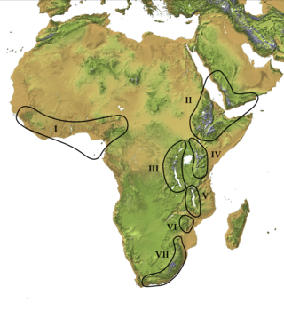
The Afromontane regions are subregions of the Afrotropical realm, one of the Earth's eight biogeographic realms, covering the plant and animal species found in the mountains of Africa and the southern Arabian Peninsula. The Afromontane regions of Africa are discontinuous, separated from each other by lower-lying areas, and are sometimes referred to as the Afromontane archipelago, as their distribution is analogous to a series of sky islands.

<span class="mw-page-title-main">Coastal forests of eastern Africa</span> Tropical moist forest region in Africa

The Coastal forests of eastern Africa, also known as the East African Coastal Forests or Zanzibar–Inhambane forests, is a tropical moist forest region along the east coast of Africa. The region was designated a biodiversity hotspot by Conservation International.

<span class="mw-page-title-main">Harenna Forest</span> Forest in Ethiopia

The Harenna Forest is a montane tropical evergreen forest in Ethiopia's Bale Mountains. The forest covers the southern slope of the mountains, extending from 1450 to 3200 meters in elevation. The Bale Mountains are in Ethiopia's Oromia Region and form the southwestern portion of the Ethiopian Highlands.

<span class="mw-page-title-main">Southern Zanzibar–Inhambane coastal forest mosaic</span> Tropical moist broadleaf forest ecoregion of eastern Africa

The Southern Zanzibar–Inhambane coastal forest mosaic, also known as the Southern Swahili coastal forests and woodlands, is a tropical moist broadleaf forest ecoregion of eastern Africa. It is a southern variation of Northern Zanzibar-Inhambane coastal forest mosaic. The ecoregion supports habitats of forest, savanna and swamps. The southern portion of the ecoregion is not as well studied due to the 1977-1992 civil war in Mozambique.

<span class="mw-page-title-main">Ethiopian montane moorlands</span>

The Ethiopian montane moorlands is a montane grasslands and shrublands ecoregion in Ethiopia. It lies above 3,000 meters elevation in the Ethiopian Highlands, the largest Afroalpine region in Africa. The montane moorlands lie above the tree line, and consist of grassland and moorland with abundant herbs and shrubs adapted to the high elevation conditions.

<span class="mw-page-title-main">Djibouti Xeric Shrublands</span> Ecoregion in northeastern Africa

The Djibouti Xeric Shrublands ecoregion is a semi-desert strip on or near the Red Sea and the Gulf of Aden coasts in Eritrea, Ethiopia, Djibouti and Somalia. This ecoregion lies mainly between sea level and 800 meters (m) elevation. There are, however, many hills and massifs, which range up to 1300 m as well as outstanding fault-induced depressions, such as the Danakil, lying as low as 155 m below sea level. This region is extremely active tectonically, experiencing many earthquakes and intermittently active volcanoes. Rainfall is very low and yearly averages range from 100 to 200 millimeters (mm), with less rain falling closer to the coast. There are many species of interest, including the endemic Archer's lark, a species of dragon tree, and a large suite of desert ungulates, including the last viable population of African wild ass.

<span class="mw-page-title-main">East African montane forests</span>

The East African montane forests is a montane tropical moist forest ecoregion of eastern Africa. The ecoregion comprises several separate areas above 2000 meters in the mountains of South Sudan, Uganda, Kenya, and Tanzania.

<span class="mw-page-title-main">East African montane moorlands</span>

The East African montane moorlands is a montane grasslands and shrublands ecoregion which occupies several high mountain peaks in Kenya, South Sudan, Tanzania, and Uganda.

<span class="mw-page-title-main">Northern Zanzibar–Inhambane coastal forest mosaic</span> Tropical forest ecoregion of East Africa

Northern Zanzibar–Inhambane coastal forest mosaic, also known as the Northern Swahili coastal forests and woodlands, is a tropical moist broadleaf forest ecoregion of coastal East Africa. The ecoregion includes a variety of habitats, including forest, savanna and swamps.

<span class="mw-page-title-main">Rwenzori–Virunga montane moorlands</span> Montane ecoregion in central Africa

The Ruwenzori-Virunga montane moorlands is a montane grasslands and shrublands ecoregion of the Rwenzori Mountains and Virunga Mountains in central Africa.

<span class="mw-page-title-main">Ethiopian montane forests</span> Tropical moist broadleaf forest ecoregion in Ethiopia

The Ethiopian montane forests is a tropical moist broadleaf forest ecoregion in Ethiopia. It covers the southwestern and southeastern portions of the Ethiopian Highlands. The ecoregion includes distinctive Afromontane evergreen forests. The ecoregion's biodiversity is threatened by deforestation, conversion to agriculture, and overgrazing.

Somali <i>Acacia</i>–<i>Commiphora</i> bushlands and thickets

The Somali AcaciaCommiphora bushlands and thickets is a semi-arid tropical grasslands, savannas, and shrublands ecoregion in the Horn of Africa. It is home to diverse communities of plants and animals, including several endemic species.

<span class="mw-page-title-main">Southwestern Arabian foothills savanna</span>

The Southwestern Arabian foothills savanna, also known as the Southwestern Arabian Escarpment shrublands and woodlands, is a desert and xeric shrubland ecoregion of the southern Arabian Peninsula, covering portions of Saudi Arabia, Yemen, and Oman.

<span class="mw-page-title-main">Victoria Basin forest–savanna mosaic</span>

The Victoria Basin forest–grassland mosaic is an ecoregion that lies mostly in Uganda and extends into neighboring countries. The ecoregion is centered north and west of Lake Victoria, with an outlier on the border of Ethiopia and South Sudan.

References

  1. 1 2 3 4 5 6 7 "Ethiopian montane grasslands and woodlands". Terrestrial Ecoregions. World Wildlife Fund.
  2. 1 2 Eric Dinerstein, David Olson, et al. (2017). An Ecoregion-Based Approach to Protecting Half the Terrestrial Realm, BioScience, Volume 67, Issue 6, June 2017, Pages 534–545; Supplemental material 2 table S1b.
  3. 1 2 Martin, Emma and Burgess, Neil. Ethiopian Montane Grasslands and Woodlands. One Earth. Retrieved 24 May 2024.
  4. White, F (1983). The vegetation of Africa: A descriptive memoir to accompany the UNESCO/AETFAT/UNSO vegetation map of Africa. Natural Resources Research. Vol. 20. Paris, France: UNESCO.
  5. Ib Friis, Sebsebe Demissew, and Paulo van Breugel (2010) Atlas of the Potential Vegetation of Africa. The Royal Danish Academy of Sciences and Letters, Copenhagen, Denmark
  6. Eric Dinerstein, David Olson, Anup Joshi, Carly Vynne, Neil D. Burgess, Eric Wikramanayake, Nathan Hahn, Suzanne Palminteri, Prashant Hedao, Reed Noss, Matt Hansen, Harvey Locke, Erle C Ellis, Benjamin Jones, Charles Victor Barber, Randy Hayes, Cyril Kormos, Vance Martin, Eileen Crist, Wes Sechrest, Lori Price, Jonathan E. M. Baillie, Don Weeden, Kierán Suckling, Crystal Davis, Nigel Sizer, Rebecca Moore, David Thau, Tanya Birch, Peter Potapov, Svetlana Turubanova, Alexandra Tyukavina, Nadia de Souza, Lilian Pintea, José C. Brito, Othman A. Llewellyn, Anthony G. Miller, Annette Patzelt, Shahina A. Ghazanfar, Jonathan Timberlake, Heinz Klöser, Yara Shennan-Farpón, Roeland Kindt, Jens-Peter Barnekow Lillesø, Paulo van Breugel, Lars Graudal, Maianna Voge, Khalaf F. Al-Shammari, Muhammad Saleem, An Ecoregion-Based Approach to Protecting Half the Terrestrial Realm, BioScience, Volume 67, Issue 6, June 2017, Pages 534–545, .
  7. Burgess, Neil D.; Hales, J.D.; Underwood, E.; Dinerstein, E. [in German] (2004). Terrestrial Ecoregions of Africa and Madagascar: A Conservation Assessment. Island Press. ISBN   978-1-55963-364-2.
  8. Eric Dinerstein, David Olson, et al. (2017). An Ecoregion-Based Approach to Protecting Half the Terrestrial Realm, BioScience, Volume 67, Issue 6, June 2017, Pages 534–545,
  9. Lillesø J-PB, et al. 2011. Potential Natural Vegetation of Eastern Africa (Ethiopia, Kenya, Malawi, Rwanda, Tanzania, Uganda and Zambia): Volume 1: The Atlas. Forest & Landscape Working Paper No 61/2011, University of Copenhagen.
  10. "Ethiopian montane forests". Terrestrial Ecoregions. World Wildlife Fund.
  11. Mekonnen, A., Fashing, P.J., Bekele, A. et al. Dietary flexibility of Bale monkeys (Chlorocebus djamdjamensis) in southern Ethiopia: effects of habitat degradation and life in fragments. BMC Ecol 18, 4 (2018). https://doi.org/10.1186/s12898-018-0161-4
  12. "Ethiopian montane grasslands and woodlands". DOPA Explorer. Accessed 7 March 2022.