Related Research Articles
Anthropology is the scientific study of humanity, concerned with human behavior, human biology, cultures, societies, and linguistics, in both the present and past, including archaic humans. Social anthropology studies patterns of behavior, while cultural anthropology studies cultural meaning, including norms and values. The term sociocultural anthropology is commonly used today. Linguistic anthropology studies how language influences social life. Biological or physical anthropology studies the biological development of humans.
Cultural anthropology is a branch of anthropology focused on the study of cultural variation among humans. It is in contrast to social anthropology, which perceives cultural variation as a subset of a posited anthropological constant. The term sociocultural anthropology includes both cultural and social anthropology traditions.

A geographic information system (GIS) consists of integrated computer hardware and software that store, manage, analyze, edit, output, and visualize geographic data. Much of this often happens within a spatial database; however, this is not essential to meet the definition of a GIS. In a broader sense, one may consider such a system also to include human users and support staff, procedures and workflows, the body of knowledge of relevant concepts and methods, and institutional organizations.
Network mapping is the study of the physical connectivity of networks e.g. the Internet. Network mapping discovers the devices on the network and their connectivity. It is not to be confused with network discovery or network enumeration which discovers devices on the network and their characteristics such as. The field of automated network mapping has taken on greater importance as networks become more dynamic and complex in nature.

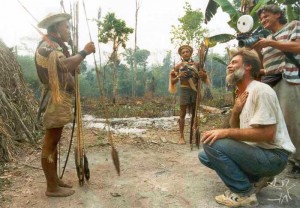
Ethnography is a branch of anthropology and the systematic study of individual cultures. Ethnography explores cultural phenomena from the point of view of the subject of the study. Ethnography is also a type of social research that involves examining the behavior of the participants in a given social situation and understanding the group members' own interpretation of such behavior.

Nonlinear dimensionality reduction, also known as manifold learning, is any of various related techniques that aim to project high-dimensional data, potentially existing across non-linear manifolds which cannot be adequately captured by linear decomposition methods, onto lower-dimensional latent manifolds, with the goal of either visualizing the data in the low-dimensional space, or learning the mapping itself. The techniques described below can be understood as generalizations of linear decomposition methods used for dimensionality reduction, such as singular value decomposition and principal component analysis.
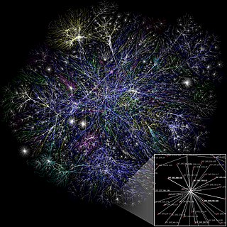
Social network analysis (SNA) is the process of investigating social structures through the use of networks and graph theory. It characterizes networked structures in terms of nodes and the ties, edges, or links that connect them. Examples of social structures commonly visualized through social network analysis include social media networks, meme spread, information circulation, friendship and acquaintance networks, peer learner networks, business networks, knowledge networks, difficult working relationships, collaboration graphs, kinship, disease transmission, and sexual relationships. These networks are often visualized through sociograms in which nodes are represented as points and ties are represented as lines. These visualizations provide a means of qualitatively assessing networks by varying the visual representation of their nodes and edges to reflect attributes of interest.
Participant observation is one type of data collection method by practitioner-scholars typically used in qualitative research and ethnography. This type of methodology is employed in many disciplines, particularly anthropology, sociology, communication studies, human geography, and social psychology. Its aim is to gain a close and intimate familiarity with a given group of individuals and their practices through an intensive involvement with people in their cultural environment, usually over an extended period of time.

Photogrammetry is the science and technology of obtaining reliable information about physical objects and the environment through the process of recording, measuring and interpreting photographic images and patterns of electromagnetic radiant imagery and other phenomena.
ArcGIS is a family of client, server and online geographic information system (GIS) software developed and maintained by Esri.
GIS or Geographic Information Systems has been an important tool in archaeology since the early 1990s. Indeed, archaeologists were early adopters, users, and developers of GIS and GIScience, Geographic Information Science. The combination of GIS and archaeology has been considered a perfect match, since archaeology often involves the study of the spatial dimension of human behavior over time, and all archaeology carries a spatial component.
Online ethnography is an online research method that adapts ethnographic methods to the study of the communities and cultures created through computer-mediated social interaction. As modifications of the term ethnography, cyber-ethnography, online ethnography and virtual ethnography designate particular variations regarding the conduct of online fieldwork that adapts ethnographic methodology. There is no canonical approach to cyber-ethnography that prescribes how ethnography is adapted to the online setting. Instead individual researchers are left to specify their own adaptations. Netnography is another form of online ethnography or cyber-ethnography with more specific sets of guidelines and rules, and a common multidisciplinary base of literature and scholars. This article is not about a particular neologism, but the general application of ethnographic methods to online fieldwork as practiced by anthropologists, sociologists, and other scholars.

Field research, field studies, or fieldwork is the collection of raw data outside a laboratory, library, or workplace setting. The approaches and methods used in field research vary across disciplines. For example, biologists who conduct field research may simply observe animals interacting with their environments, whereas social scientists conducting field research may interview or observe people in their natural environments to learn their languages, folklore, and social structures.

Video ethnography is the video recording of the stream of activity of subjects in their natural setting, in order to experience, interpret, and represent culture and society. Ethnographic video, in contrast to ethnographic film, cannot be used independently of other ethnographic methods, but rather as part of the process of creation and representation of societal, cultural, and individual knowledge. It is commonly used in the fields of visual anthropology, visual sociology, visual ethnography and cultural studies. Uses of video in ethnography include the recording of certain processes and activities, visual note-taking, and ethnographic diary-keeping.

Geography is the study of the lands, features, inhabitants, and phenomena of Earth. Geography is an all-encompassing discipline that seeks an understanding of Earth and its human and natural complexities—not merely where objects are, but also how they have changed and come to be. While geography is specific to Earth, many concepts can be applied more broadly to other celestial bodies in the field of planetary science. Geography has been called "a bridge between natural science and social science disciplines."
Ethnoscience has been defined as an attempt "to reconstitute what serves as science for others, their practices of looking after themselves and their bodies, their botanical knowledge, but also their forms of classification, of making connections, etc.".
SpicyNodes was a system for displaying hierarchical data, in which a focus node displays detailed information, and the surrounding nodes represent related information, with a layout based on radial maps. It has web (Flash) and mobile (iOS) implementations. It has ended operation as of 1 January 2018.
Geographic information systems (GIS) play a constantly evolving role in geospatial intelligence (GEOINT) and United States national security. These technologies allow a user to efficiently manage, analyze, and produce geospatial data, to combine GEOINT with other forms of intelligence collection, and to perform highly developed analysis and visual production of geospatial data. Therefore, GIS produces up-to-date and more reliable GEOINT to reduce uncertainty for a decisionmaker. Since GIS programs are Web-enabled, a user can constantly work with a decision maker to solve their GEOINT and national security related problems from anywhere in the world. There are many types of GIS software used in GEOINT and national security, such as Google Earth, ERDAS IMAGINE, GeoNetwork opensource, and Esri ArcGIS.

Cartographic design or map design is the process of crafting the appearance of a map, applying the principles of design and knowledge of how maps are used to create a map that has both aesthetic appeal and practical function. It shares this dual goal with almost all forms of design; it also shares with other design, especially graphic design, the three skill sets of artistic talent, scientific reasoning, and technology. As a discipline, it integrates design, geography, and geographic information science.

Qualitative geography is a subfield and methodological approach to geography focusing on nominal data, descriptive information, and the subjective and interpretive aspects of how humans experience and perceive the world. Often, it is concerned with understanding the lived experiences of individuals and groups and the social, cultural, and political contexts in which those experiences occur. Thus, qualitative geography is traditionally placed under the branch of human geography; however, technical geographers are increasingly directing their methods toward interpreting, visualizing, and understanding qualitative datasets, and physical geographers employ nominal qualitative data as well as quanitative. Furthermore, there is increased interest in applying approaches and methods that are generally viewed as more qualitative in nature to physical geography, such as in critical physical geography. While qualitative geography is often viewed as the opposite of quantitative geography, the two sets of techniques are increasingly used to complement each other. Qualitative research can be employed in the scientific process to start the observation process, determine variables to include in research, validate results, and contextualize the results of quantitative research through mixed-methods approaches.
References
- 1 2 3 ""Ethnographic Mapping" in "Ethnography Made Simple" on Manifold Scholarship at CUNY". Manifold Scholarship. Retrieved 2020-11-01.
- ↑ Werner, Oswald; Kuznar, Lawrence A. (2001). "Ethnographic Mapmaking: Part 2—Practical Concerns and Triangulation". Field Methods. 13 (3): 291–296. doi: 10.1177/1525822X0101300305 . S2CID 56252954.
- ↑ Campbell, John (2002). "Interdisciplinary Research and GIS: Why Local and Indigenous Knowledge is Discounted". In Sillitoe, P.; Bicker, A.; Pottier, J. (eds.). Participating in Development. Approaches to Indigenous Knowledge. London: Routledge. pp. 189–205. Retrieved November 1, 2020– via ResearchGate.
- ↑ Brennan-Horley, Chris; Luckman, Susan (2010). "GIS, Ethnography, and Cultural Research: Putting Maps Back Into Ethnographic Mapping". The Information Society. 26 (2): 92–103. doi:10.1080/01972240903562712. S2CID 30376053 – via ResearchGate.
- ↑ Kuznar, Lawrence A.; Werner, Oswald (2001). "Ethnographic Mapmaking: Part 1—Principles". Field Methods. 13 (2): 204–213. doi: 10.1177/1525822X0101300206 . S2CID 62161246.