Eulonia, Georgia

Last updated
Eulonia, Georgia
Eulonia, GA, US.jpg
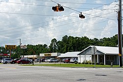
The main intersection
USA Georgia location map.svg
Red pog.svg
Eulonia
Usa edcp location map.svg
Red pog.svg
Eulonia
Coordinates: 31°31′59″N81°25′37″W / 31.53306°N 81.42694°W / 31.53306; -81.42694
Country United States
State Georgia
County McIntosh
Area
[1]
  Total3.28 sq mi (8.5 km2)
  Land3.23 sq mi (8.4 km2)
  Water0.05 sq mi (0.1 km2)
Elevation
16 ft (5 m)
Population
 (2020) [2]
  Total351
  Density108.7/sq mi (42.0/km2)
Time zone UTC-5 (Eastern (EST))
  Summer (DST) UTC-4 (EDT)
ZIP code
31331 (Townsend)
FIPS code 13-28016

Eulonia is an unincorporated community and census-designated place (CDP) in McIntosh County in the U.S. state of Georgia. Part of the Brunswick, Georgia Metropolitan Statistical Area, it is in the Low Country between Savannah and Brunswick near Interstate 95. [3]

Contents

It was first listed as a CDP in the 2020 census with a population of 351. [2]

Geography

Eulonia is in central McIntosh, with the CDP centered around the intersection of U.S. Route 17 and Georgia State Route 99. The historic community of Eulonia is 0.6 miles (1.0 km) north of the crossroads. US 17 leads south 11 miles (18 km) to Darien, the county seat, and north 15 miles (24 km) to Riceboro. SR 99 leads east 4 miles (6 km) to Crescent and west 1 mile (1.6 km) to Interstate 95 at Exit 58. I-95, which forms the western edge of the Eulonia CDP, leads north 52 miles (84 km) to Savannah and south 28 miles (45 km) to Brunswick.

According to the U.S. Census Bureau, the Eulonia CDP has a total area of 3.3 square miles (8.5 km2), of which 0.05 square miles (0.13 km2), or 1.43%, are water. [1] The tidal Sapelo River forms the northern edge of the CDP and runs out to the Atlantic Ocean 15 miles (24 km) to the east at Sapelo Sound.

Demographics

Historical population
CensusPop.Note
2020 351
U.S. Decennial Census [4]
2020 [5]

Eulonia was first listed as a census designated place in the 2020 U.S. Census. [5]

Eulonia CDP, Georgia – Racial and ethnic composition
Note: the US Census treats Hispanic/Latino as an ethnic category. This table excludes Latinos from the racial categories and assigns them to a separate category. Hispanics/Latinos may be of any race.
Race / Ethnicity (NH = Non-Hispanic)Pop 2020 [5] % 2020
White alone (NH)11532.76%
Black or African American alone (NH)21862.11%
Native American or Alaska Native alone (NH)00.00%
Asian alone (NH)20.57%
Pacific Islander alone (NH)00.00%
Some Other Race alone (NH)10.28%
Mixed Race or Multi-Racial (NH)30.85%
Hispanic or Latino (any race)123.42%
Total351100.00%

In 2020, its population was 351.

Related Research Articles

<span class="mw-page-title-main">North Fort Myers, Florida</span> Census-designated place in Florida, United States

North Fort Myers is an unincorporated area and census-designated place (CDP) in Lee County, Florida, United States. It is part of the Cape Coral-Fort Myers, Florida Metropolitan Statistical Area. The population was 42,719 at the 2020 census.

<span class="mw-page-title-main">Golden Glades, Florida</span> Census-designated place in Florida

Golden Glades is a census-designated place (CDP) in Miami-Dade County, Florida, United States. It is part of the Miami metropolitan area of South Florida. The population was 32,499 at the 2020 US census.

<span class="mw-page-title-main">Ives Estates, Florida</span> Census-designated place in Florida

Ives Estates is a census-designated place (CDP) in Miami-Dade County, Florida. It is part of the Miami metropolitan area of South Florida. The population was 25,005 at the 2020 census, up from 19,525 in 2010.

<span class="mw-page-title-main">West Perrine, Florida</span> Census-designated place in Florida

West Perrine is a census-designated place (CDP) in Miami-Dade County, Florida, United States. It is part of the Miami metropolitan area of South Florida. The population was 10,602 at the 2020 census, up from 9,460 in 2010.

<span class="mw-page-title-main">Georgetown, Chatham County, Georgia</span> Place in Georgia, United States

Georgetown is an unincorporated community and census-designated place (CDP) in Chatham County, Georgia, United States. The population was 11,916 at the 2020 U.S. census. Georgetown lies across the Little Ogeechee River from Savannah, Georgia, and is a suburban "bedroom community" of Savannah, where most of its adult residents work. It is part of the Savannah Metropolitan Statistical Area.

<span class="mw-page-title-main">Montgomery, Georgia</span> Place in Georgia, United States

Montgomery is an unincorporated community and census-designated place (CDP) in Chatham County, Georgia, United States. The population was 4,443 at the 2020 United States census, down slightly from 4,523 in 2010. It is a suburb of Savannah and is part of the Savannah metropolitan area.

<span class="mw-page-title-main">Whitemarsh Island, Georgia</span> Place in Georgia, United States

Whitemarsh Island is an unincorporated community and census-designated place (CDP) in Chatham County, Georgia, United States. The population was 6,983 at the 2020 U.S census. It is part of the Savannah metropolitan statistical area. The communities of Whitemarsh Island are a relatively affluent suburb of Savannah.

<span class="mw-page-title-main">Martinez, Georgia</span> Place in Georgia, United States

Martinez is an unincorporated community and census-designated place (CDP) in Columbia County, Georgia, United States. It is a northwestern suburb of Augusta and is part of the Augusta, Georgia metropolitan area. The population was 34,535 at the 2020 census.

<span class="mw-page-title-main">Country Club Estates, Georgia</span> Place in Georgia, United States

Country Club Estates is an unincorporated community and census-designated place (CDP) in Glynn County, Georgia, United States. It is part of the Brunswick metropolitan statistical area. The population was 8,373 at the 2020 census, down from 8,545 in 2010.

<span class="mw-page-title-main">Oglethorpe, Georgia</span> City in Georgia, United States

Oglethorpe is a city in Macon County, Georgia, United States. The population was 995 at the 2020 census, down from 1,328 in 2010. The city is the county seat of Macon County. It was named for Georgia's founder, James Oglethorpe.

Bolingbroke, founded in 1867, is an unincorporated community and census-designated place (CDP) in Monroe County, Georgia, United States. It lies just north of Macon, between Interstates 475 and 75. The community is part of the Macon metropolitan statistical area.

Smarr is an unincorporated community and census-designated place (CDP) in Monroe County, in the U.S. state of Georgia. The 2020 census listed a population of 218.

Perkins is a census-designated place and unincorporated community in Jenkins County, Georgia, United States. As of the 2010 census it had a population of 91.

Crescent is an unincorporated community and census-designated place (CDP) in McIntosh County, Georgia, United States. It lies along State Route 99, 12 miles (19 km) north of the city of Darien, the county seat of McIntosh County. Its elevation is 30 feet (9.1 m) above sea level. It has a post office with the ZIP code 31304.

<span class="mw-page-title-main">Yarborough Landing, Arkansas</span> Census-designated place in Arkansas, United States

Yarborough Landing is a census-designated place in Little River County, Arkansas, United States. Per the 2020 census, the population was 457.

Victoria is a census-designated place and unincorporated community in Marshall County, Mississippi, United States. It was first listed as a CDP in the 2020 census, which recorded a population of 1,066.

Dutch Island is an unincorporated community and census-designated place (CDP) in Chatham County, Georgia, United States. It is part of the Savannah Metropolitan Statistical Area, and at the 2020 census, its population was 1,238.

Henderson is an unincorporated community and census-designated place (CDP) in Chatham County, Georgia, United States. The population was 2,178 at the 2020 census. It is part of the Savannah metropolitan statistical area.

Talahi Island is a barrier island, unincorporated community, and census-designated place (CDP) in Chatham County, Georgia, United States. The population was 1,247 at the 2020 census. Located between Savannah and the beach resort town of Tybee Island, Talahi Island is part of the Savannah Metropolitan Statistical Area.

<span class="mw-page-title-main">Tazewell, Georgia</span> Place in Georgia, United States

Tazewell is an unincorporated community and census-designated place (CDP) in Marion County, in the U.S. state of Georgia.

References

  1. 1 2 "2022 U.S. Gazetteer Files: Georgia". United States Census Bureau. Retrieved January 24, 2023.
  2. 1 2 "P1. Race – Eulonia CDP, Georgia: 2020 DEC Redistricting Data (PL 94-171)". U.S. Census Bureau. Retrieved January 24, 2023.
  3. "US Gazetteer files: 2010, 2000, and 1990". United States Census Bureau. 2011-02-12. Retrieved 2011-04-23.
  4. "Decennial Census of Population and Housing by Decades". US Census Bureau.
  5. 1 2 3 "P2 Hispanic or Latino, and Not Hispanic or Latino by Race – 2020: DEC Redistricting Data (PL 94-171) – Eulonia CDP, Georgia". United States Census Bureau .