Everson, Pennsylvania

Last updated

Everson, Pennsylvania
Everson Pa 2011.jpg
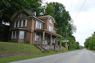
Brown Street in Everson
Fayette County Pennsylvania Incorporated and Unincorporated areas Everson Highlighted.svg
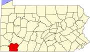
Location of Everson in Fayette County, Pennsylvania.
USA Pennsylvania location map.svg
Red pog.svg
Everson
Location in Pennsylvania
Usa edcp location map.svg
Red pog.svg
Everson
Everson (the United States)
Coordinates: 40°5′26″N79°35′13″W / 40.09056°N 79.58694°W / 40.09056; -79.58694
CountryUnited States
State Pennsylvania
County Fayette
Established1903
Government
  MayorTim Shoemaker
Area
[1]
  Total0.22 sq mi (0.56 km2)
  Land0.22 sq mi (0.56 km2)
  Water0.00 sq mi (0.00 km2)
Elevation
1,070 ft (330 m)
Population
 (2020) [2]
  Total771
  Density3,569.44/sq mi (1,378.17/km2)
Time zone UTC-4 (EST)
  Summer (DST) UTC-5 (EDT)
ZIP code
15631 [3]
Area code 724

Everson is a borough in Fayette County, Pennsylvania, United States. The population was 768 at the 2020 census. [4] It was incorporated in 1903.

Contents

Geography

Everson is located on the northern edge of Fayette County at 40°5′26″N79°35′13″W / 40.09056°N 79.58694°W / 40.09056; -79.58694 (40.090582, −79.587043). [5] It is on the south side of Jacobs Creek, a tributary of the Youghiogheny River and which forms the border with Westmoreland County. The borough of Scottdale is to the north, directly across the creek from Everson. The city of Connellsville is 6 miles (10 km) to the south.

According to the U.S. Census Bureau, Everson has a total area of 0.19 square miles (0.50 km2), all land. [6]

Demographics

Historical population
CensusPop.Note
1890 905
1910 1,759
1920 1,98813.0%
1930 1,900−4.4%
1940 1,809−4.8%
1950 1,520−16.0%
1960 1,304−14.2%
1970 1,143−12.3%
1980 1,032−9.7%
1990 939−9.0%
2000 842−10.3%
2010 793−5.8%
2020 768−3.2%
2021 (est.)756 [4] −1.6%
Sources: [7] [8] [9] [2]

As of the 2000 census, [8] there were 842 people, 351 households, and 233 families residing in the borough. The population density was 3,869.6 inhabitants per square mile (1,494.1/km2). There were 385 housing units at an average density of 1,769.4 per square mile (683.2/km2). The racial makeup of the borough was 96.08% White, 3.44% African American, 0.12% Asian, and 0.36% from two or more races.

There were 351 households, out of which 29.6% had children under the age of 18 living with them, 49.0% were married couples living together, 10.0% had a female householder with no husband present, and 33.6% were non-families. 29.3% of all households were made up of individuals, and 16.2% had someone living alone who was 65 years of age or older. The average household size was 2.40 and the average family size was 2.94.

In the borough, the population was spread out, with 22.4% under the age of 18, 7.8% from 18 to 24, 29.6% from 25 to 44, 19.1% from 45 to 64, and 21.0% who were 65 years of age or older. The median age was 39 years. For every 100 females, there were 98.6 males. For every 100 females age 18 and over, there were 91.5 males.

The median income for a household in the borough was $25,500, and the median income for a family was $30,769. Males had a median income of $25,972 versus $17,188 for females. The per capita income for the borough was $12,928. About 13.9% of families and 15.9% of the population were below the poverty line, including 27.8% of those under age 18 and 12.5% of those age 65 or over.

Education

Everson is served by the Southmoreland School District.

Notable person

Related Research Articles

<span class="mw-page-title-main">Heidelberg, Pennsylvania</span> Borough in Pennsylvania, United States

Heidelberg is a borough located southwest of Pittsburgh in Allegheny County, Pennsylvania, United States. The population was 1,288 at the 2020 census. The borough was named after Heidelberg in Germany, the native home of a large share of the early settlers.
<span class="mw-page-title-main">Brownsville Township, Fayette County, Pennsylvania</span> Township in Pennsylvania, United States

Brownsville Township is a township in Fayette County, Pennsylvania, United States. The population was 534 at the 2020 census, a decline from the figure of 683 tabulated in 2010. It is served by the Brownsville School District.

<span class="mw-page-title-main">Connellsville Township, Fayette County, Pennsylvania</span> Township in Pennsylvania, United States

Connellsville Township is a township in Fayette County, Pennsylvania, United States. The population was 2,072 at the 2020 census, a decline from the figure of 2,391 tabulated in 2010.

<span class="mw-page-title-main">Dawson, Pennsylvania</span> Borough in Pennsylvania, United States

Dawson is a borough in Fayette County, Pennsylvania, United States. The population was 352 at the 2020 census, a decline from the figure of 367 tabulated in 2010.

<span class="mw-page-title-main">Dunbar, Pennsylvania</span> Borough in Pennsylvania, United States

Dunbar is a borough in Fayette County, Pennsylvania, United States. The population was 1,013 at the time of the 2020 census, a decline from the figure of 1,042 tabulated in 2010.

<span class="mw-page-title-main">Dunbar Township, Fayette County, Pennsylvania</span> Township in Pennsylvania, United States

Dunbar Township is a township in Fayette County, Pennsylvania, United States. The population was 6,664 at the 2020 census, a decline from the figure of 7,126 tabulated in 2010.

<span class="mw-page-title-main">Fayette City, Pennsylvania</span> Borough in Pennsylvania, United States

Fayette City is a borough in Fayette County, Pennsylvania, United States. The population was 502 at the 2020 census, a decline from the figure of 596 tabulated in 2010. It is served by the Belle Vernon Area School District. Some buildings in the town antedate 1820.

<span class="mw-page-title-main">Jefferson Township, Fayette County, Pennsylvania</span> Township in Pennsylvania, United States

Jefferson Township is a township in Fayette County, Pennsylvania, United States. The population was 2,008 at the 2020 census, a decline from the figure of 2,008 tabulated in 2010. It is named for former president Thomas Jefferson, and many of the township's streets are named after other U.S. presidents. Frazier School District serves the area.

<span class="mw-page-title-main">Lower Tyrone Township, Pennsylvania</span> Township in Pennsylvania, United States

Lower Tyrone Township is a township in Fayette County, Pennsylvania, United States. The population was 1,071 at the time of the 2020 census.

<span class="mw-page-title-main">Markleysburg, Pennsylvania</span> Borough in Pennsylvania, United States

Markleysburg is a borough in Fayette County, Pennsylvania, United States. The population was 246 at the 2020 census. The borough is served by the Uniontown Area School District.

<span class="mw-page-title-main">Newell, Pennsylvania</span> Borough in Pennsylvania, United States

Newell is a borough in Fayette County, Pennsylvania, United States. The population was 512 at the time of the 2020 census.

<span class="mw-page-title-main">Perryopolis, Pennsylvania</span> Borough in Pennsylvania, United States

Perryopolis is a borough in Fayette County, Pennsylvania, United States. The borough is part of the Pittsburgh metropolitan area. The population was 1,705 at the 2020 census.

<span class="mw-page-title-main">Upper Tyrone Township, Pennsylvania</span> Township in Pennsylvania, United States

Upper Tyrone Township is a township that is located in Fayette County, Pennsylvania, United States. The population was 1,768 at the time of the 2020 census. It is served by the Southmoreland School District.

<span class="mw-page-title-main">Vanderbilt, Pennsylvania</span> Borough in Pennsylvania, United States

Vanderbilt is a borough in Fayette County, Pennsylvania, United States. The population was 414 at the 2020 census, a decline from the figure of 476 tabulated in 2010. The town is named for the railroad tycoon Cornelius Vanderbilt and is served by the Connellsville Area School District.

<span class="mw-page-title-main">Centerville, Washington County, Pennsylvania</span> Borough in Washington County, Pennsylvania, United States

Centerville is a borough in Washington County, Pennsylvania, United States. The population was 3,254 at the 2020 census.

<span class="mw-page-title-main">Dunlevy, Pennsylvania</span> Borough in Pennsylvania, United States

Dunlevy is a borough in Washington County, Pennsylvania, United States. The population was 369 at the 2020 census.

<span class="mw-page-title-main">Elco, Pennsylvania</span> Borough in Pennsylvania, United States

Elco is a borough in Washington County, Pennsylvania, United States. The population was 263 at the 2020 census.

<span class="mw-page-title-main">Stockdale, Pennsylvania</span> Borough in Pennsylvania, United States

Stockdale is a borough that is located in Washington County, Pennsylvania, United States. The population was 424 at the time of the 2020 census.

Lynnwood-Pricedale is a census-designated place (CDP) in Fayette and Westmoreland counties in the Pennsylvania. The population was 2,031 at the 2010 census, down from 2,168 at the 2000 census. The community of Lynwood is located in Fayette County's Washington Township, while Pricedale is part of Westmoreland County's Rostraver Township.

<span class="mw-page-title-main">Seven Springs, Pennsylvania</span> Borough in Pennsylvania, United States

Seven Springs is a borough in Somerset and Fayette counties in the U.S. state of Pennsylvania. The Fayette County portion of the borough and resort are part of the Pittsburgh metropolitan area, and the Somerset County portion is part of the Johnstown Metropolitan Area. The population of the borough was 26 as of the 2010 census, compared to 127 at the 2000 census. Fifteen of the residents in 2010 were in Fayette County, and 11 in Somerset County.

References

  1. "ArcGIS REST Services Directory". United States Census Bureau. Retrieved October 15, 2022.
  2. 1 2 "Census Population API". United States Census Bureau. Retrieved October 12, 2022.
  3. "Everson PA ZIP Code". zipdatamaps.com. 2023. Retrieved June 27, 2023.
  4. 1 2 Bureau, US Census. "City and Town Population Totals: 2020—2021". Census.gov. US Census Bureau. Retrieved July 24, 2022.
  5. "US Gazetteer files: 2010, 2000, and 1990". United States Census Bureau. February 12, 2011. Retrieved April 23, 2011.
  6. "Geographic Identifiers: 2010 Census Summary File 1 (G001), Everson borough, Pennsylvania". American FactFinder. U.S. Census Bureau. Archived from the original on February 13, 2020. Retrieved July 7, 2016.
  7. "Census of Population and Housing". U.S. Census Bureau. Retrieved December 11, 2013.
  8. 1 2 "U.S. Census website". United States Census Bureau . Retrieved January 31, 2008.
  9. "Incorporated Places and Minor Civil Divisions Datasets: Subcounty Resident Population Estimates: April 1, 2010 to July 1, 2012". Population Estimates. U.S. Census Bureau. Archived from the original on June 11, 2013. Retrieved December 11, 2013.