
The United Nations Convention on the Law of the Sea (UNCLOS), also called the Law of the Sea Convention or the Law of the Sea Treaty, is an international agreement that establishes a legal framework for all marine and maritime activities. As of June 2016, 167 countries and the European Union are parties.

The terms international waters or trans-boundary waters apply where any of the following types of bodies of water transcend international boundaries: oceans, large marine ecosystems, enclosed or semi-enclosed regional seas and estuaries, rivers, lakes, groundwater systems (aquifers), and wetlands.
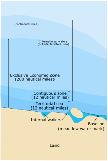
The term territorial waters is sometimes used informally to refer to any area of water over which a sovereign state has jurisdiction, including internal waters, the territorial sea, the contiguous zone, the exclusive economic zone, and potentially the extended continental shelf. In a narrower sense, the term is used as a synonym for the territorial sea.

Law of the sea is a body of international law governing the rights and duties of states in maritime environments. It concerns matters such as navigational rights, sea mineral claims, and coastal waters jurisdiction.

An exclusive economic zone (EEZ), as prescribed by the 1982 United Nations Convention on the Law of the Sea, is an area of the sea in which a sovereign state has special rights regarding the exploration and use of marine resources, including energy production from water and wind. It stretches from the outer limit of the territorial sea out to 200 nautical miles (nmi) from the coast of the state in question. It is also referred to as a maritime continental margin and, in colloquial usage, may include the continental shelf. The term does not include either the territorial sea or the continental shelf beyond the 200 nautical mile limit. The difference between the territorial sea and the exclusive economic zone is that the first confers full sovereignty over the waters, whereas the second is merely a "sovereign right" which refers to the coastal state's rights below the surface of the sea. The surface waters, as can be seen in the map, are international waters.
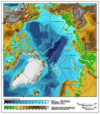
The Arctic consists of land, internal waters, territorial seas, exclusive economic zones (EEZs) and international waters above the Arctic Circle. All land, internal waters, territorial seas and EEZs in the Arctic are under the jurisdiction of one of the eight Arctic coastal states: Canada, Denmark, Finland, Iceland, Norway, Russia, Sweden and the United States. International law regulates this area as with other portions of Earth.

The Australia–Indonesia border is a maritime boundary running west from the two countries' tripoint maritime boundary with Papua New Guinea in the western entrance to the Torres Straits, through the Arafura Sea and Timor Sea, and terminating in the Indian Ocean. The boundary is, however, broken by the Timor Gap, where Australian and East Timorese territorial waters meet and where the two countries have overlapping claims to the seabed.

The United States was among the nations that participated in the third United Nations Conference on the Law of the Sea, which took place from 1974 through 1982 and resulted in the international treaty known as the United Nations Convention on the Law of the Sea (UNCLOS). The United States also participated in the subsequent negotiations of modifications to the treaty from 1990 to 1994. The UNCLOS came into force in 1994. Although the United States now recognizes the UNCLOS as a codification of customary international law, it has not ratified it.
A maritime boundary is a conceptual division of the Earth's water surface areas using physiographic or geopolitical criteria. As such, it usually bounds areas of exclusive national rights over mineral and biological resources, encompassing maritime features, limits and zones. Generally, a maritime boundary is delineated at a particular distance from a jurisdiction's coastline. Although in some countries the term maritime boundary represents borders of a maritime nation that are recognized by the United Nations Convention on the Law of the Sea, maritime borders usually serve to identify the edge of international waters.

The Republic of Cyprus (Cyprus) and Turkey have been engaged in a dispute over the extent of their exclusive economic zones (EEZ), ostensibly sparked by oil and gas exploration in the area. Turkey objects to Cypriot drilling in waters that Cyprus has asserted a claim to under international maritime law. The present maritime zones dispute touches on the perennial Cyprus and Aegean disputes; Turkey is the only member state of the United Nations that does not recognise Cyprus, and is one of the few not signatory to the United Nations Convention on the Law of the Sea, which Cyprus has signed and ratified.

There are disputes between China, Japan, Taiwan and South Korea over the extent of their respective exclusive economic zones (EEZs) in the East China Sea.

Several states have claimed interests over the sea bed adjoining Rockall, an uninhabitable granite islet which is located within the exclusive economic zone (EEZ) of the United Kingdom. Ireland, Denmark, Iceland, and the United Kingdom have all made submissions to the commission set up under the United Nations Convention on the Law of the Sea (UNCLOS).
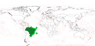
The Blue Amazon or Brazilian maritime territory is the exclusive economic zone (EEZ) of Brazil. It is an offshore area of 3.6 million square km on the Brazilian coast, rich in marine biodiversity and energy resources. The size is equivalent to the surface of the Amazon rainforest. The name is a reference to the biologically rich region of the Brazilian Amazon, with the addition of the adjective blue denoting the ocean.

Japan has the eighth-largest exclusive economic zone (EEZ) in the world. The total area of Japan is about 37 km. Japan's EEZ area is vast and the territorial waters and EEZ together is about 12 million km2.

Australia's exclusive economic zone (EEZ) was declared on 1 August 1994 and extends from 12 to 200 nautical miles from the coastline of Australia and its external territories, except where a maritime delimitation agreement exists with another state. To the 12 nautical-mile boundary is Australia's territorial waters. Australia has the third-largest exclusive economic zone, behind the United States and France but ahead of Russia, with the total area of 8,148,250 square kilometres (3,146,060 sq mi), which exceeds its land territory.
Vietnam claims an exclusive economic zone (EEZ) of 1,395,096 km2 (538,650 sq mi) with 200 nautical miles from its shores.

Indonesia has the sixth-largest exclusive economic zone in the world with 6,159,032 km2 (2,378,016 sq mi). It claims an EEZ of 200 nautical miles (370 km) from its shores. This is due to the 13,466 islands of the Indonesian archipelago. It has the 3rd largest coastline of 54,720 km (34,000 mi). It is located in Southeast Asia between the Indian Ocean and the Pacific Ocean.

India has the 18th-largest exclusive economic zone (EEZ) with a total size of 2,305,143 km2 (890,021 sq mi). It includes the Lakshadweep island group in the Laccadive Sea off the southwestern coast of India and the Andaman and Nicobar Islands at the Bay of Bengal and the Andaman Sea. India's EEZ is bordered to the west by Pakistan, to the south by the Maldives and Sri Lanka and to the east by Bangladesh, Myanmar, Thailand, Malaysia and Indonesia. Based on new scientific data, India has petitioned United Nations to extend its EEZ from 200 Nautical miles to 350 miles.

The exclusive economic zone of Canada is the area of the sea in which Canada has special rights regarding the exploration and use of marine resources, as prescribed by the 1982 United Nations Convention on the Law of the Sea.
Seabed mining, also known as Seafloor mining is the recovery of minerals from the seabed by techniques of underwater mining. The concept includes mining at shallow depths on the continental shelf and deep-sea mining at greater depths associated with tectonic activity, hydrothermal vents and the abyssal plains. While there is opportunity for economical mineral extraction at areas of high concentration of valuable minerals, there is also significant risk of ecological damage of unknown and to some degree, unpredictable, extent. Increasing requirements for minerals and metals, largely for use in the technology sector, has led to renewed interest in exploitation of seabed mineral resources. including massive polymetallic sulfide deposits around hydrothermal vents, cobalt-rich crusts on the sides of seamounts and fields of manganese nodules on the abyssal plains.
