Related Research Articles

Constantius II was Roman emperor from 337 to 361. His reign saw constant warfare on the borders against the Sasanian Empire and Germanic peoples, while internally the Roman Empire went through repeated civil wars, court intrigues, and usurpations. His religious policies inflamed domestic conflicts that would continue after his death.
Perinthus or Perinthos was a great and flourishing town of ancient Thrace, situated on the Propontis. According to John Tzetzes, it bore at an early period the name of Mygdonia (Μυγδονία). It lay 35 kilometres (22 mi) west of Selymbria and 90 kilometres (56 mi) west of Byzantium, on a small peninsula of the bay which bears its name, and was built like an amphitheatre, on the declivity of a hill. Its site is near modern Marmara Ereğlisi, in Turkey.

Abraham Ortelius was a cartographer, geographer, and cosmographer from Antwerp in the Spanish Netherlands. He is recognized as the creator of the first modern atlas, the Theatrum Orbis Terrarum. Along with Gemma Frisius and Gerardus Mercator, Ortelius is generally considered one of the founders of the Netherlandish school of cartography and geography. He was a notable figure of this school in its golden age and an important geographer of Spain during the age of discovery. The publication of his atlas in 1570 is often considered as the official beginning of the Golden Age of Netherlandish cartography. He was the first person proposing that the continents were joined before drifting to their present positions.
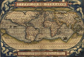
Theatrum Orbis Terrarum is considered to be the first true modern atlas. Written by Abraham Ortelius, strongly encouraged by Gillis Hooftman and originally printed on 20 May 1570 in Antwerp, it consisted of a collection of uniform map sheets and supporting text bound to form a book for which copper printing plates were specifically engraved. The Ortelius atlas is sometimes referred to as the summary of sixteenth-century cartography. The publication of the Theatrum Orbis Terrarum (1570) is often considered as the official beginning of the Golden Age of Netherlandish cartography.

John Amos Comenius was a Moravian philosopher, pedagogue and theologian who is considered the father of modern education. He served as the last bishop of the Unity of the Brethren before becoming a religious refugee and one of the earliest champions of universal education, a concept eventually set forth in his book Didactica Magna. As an educator and theologian, he led schools and advised governments across Protestant Europe through the middle of the seventeenth century.
Macrobius Ambrosius Theodosius, usually referred to as Macrobius, was a Roman provincial who lived during the early fifth century, during late antiquity, the period of time corresponding to the Later Roman Empire, and when Latin was as widespread as Greek among the elite. He is primarily known for his writings, which include the widely copied and read Commentarii in Somnium Scipionis about Somnium Scipionis, which was one of the most important sources for Neoplatonism in the Latin West during the Middle Ages; the Saturnalia, a compendium of ancient Roman religious and antiquarian lore; and De differentiis et societatibus graeci latinique verbi, which is now lost. He is the basis for the protagonist Manlius in Iain Pears' book The Dream of Scipio.

Nusaybin is a municipality and district of Mardin Province, Turkey. Its area is 1,079 km2, and its population is 115,586 (2022). The city is populated by Kurds of different tribal affiliation.

Dionysius Periegetes, also known as Dionysius of Alexandria or Dionysius the African, was the author of a description of the then-known world in Greek hexameter verse. He is believed to have been from Alexandria and to have lived around the time of Hadrian, though some date his lifetime as late as the end of the 3rd century.
Postumius Rufius Festus Avienius was a Latin writer of the 4th century AD. He was a native of Volsinii in Etruria, from the distinguished family of the Rufii Festi.
The earliest known world maps date to classical antiquity, the oldest examples of the 6th to 5th centuries BCE still based on the flat Earth paradigm. World maps assuming a spherical Earth first appear in the Hellenistic period. The developments of Greek geography during this time, notably by Eratosthenes and Posidonius culminated in the Roman era, with Ptolemy's world map, which would remain authoritative throughout the Middle Ages. Since Ptolemy, knowledge of the approximate size of the Earth allowed cartographers to estimate the extent of their geographical knowledge, and to indicate parts of the planet known to exist but not yet explored as terra incognita.
The Johannes Schöner globes are a series of globes made by Johannes Schöner (1477–1547), the first being made in 1515. Schöner's globes are some of the oldest still in existence. Some of them are said by some authors to show parts of the world that were not yet known to Europeans, such as the Magellan Strait and the Antarctic.

The Jagiellonian globe, also known as the Globus Jagellonicus, is a mechanical armillary sphere made in France before 1510. It is an astronomical instrument and a universal clock tracking both local solar time and sidereal time. The central brass sphere is engraved with a map of Earth and contains the clock mechanism. It is the oldest extant globe to use the name America.

Theatrum Chemicum is a compendium of early alchemical writings published in six volumes over the course of six decades. The first three volumes were published in 1602, while the final sixth volume was published in its entirety in 1661. Theatrum Chemicum remains the most comprehensive collective work on the subject of alchemy ever published in the Western world.

Regio Patalis is Latin for “the region of Patala”, that is the region around the ancient city of Patala at the mouth of the Indus River in Sindh, Pakistan. The historians of Alexander the Great state that the Indus parted into two branches at the city of Patala before reaching the sea, and the island thus formed was called Patalene, the district of Patala. Alexander constructed a harbour at Patala.
The religious policies of Constantius II were a mixture of toleration for some pagan practices and repression for other pagan practices. He also sought to advance the Arian or Semi-Arianian heresy within Christianity. These policies may be contrasted with the religious policies of his father, Constantine the Great, whose Catholic orthodoxy was espoused in the Nicene Creed and who largely tolerated paganism in the Roman Empire. Constantius also sought to repress Judaism.

The Mercator world map of 1569 is titled Nova et Aucta Orbis Terrae Descriptio ad Usum Navigantium Emendate Accommodata. The title shows that Gerardus Mercator aimed to present contemporary knowledge of the geography of the world and at the same time 'correct' the chart to be more useful to sailors. This 'correction', whereby constant bearing sailing courses on the sphere are mapped to straight lines on the plane map, characterizes the Mercator projection. While the map's geography has been superseded by modern knowledge, its projection proved to be one of the most significant advances in the history of cartography, inspiring the 19th century map historian Adolf Nordenskiöld to write "The master of Rupelmonde stands unsurpassed in the history of cartography since the time of Ptolemy." The projection heralded a new era in the evolution of navigation maps and charts and it is still their basis.

Wine in Palestine has been in production for several years. In the region of Palestine, the use of wine was not only an important factor in Jewish religious ritual, but also a necessity for social interaction, general dietary consumption and medicinal purposes. During the Byzantine period, large-scale production led to international commerce in the commodity, and Palestinian wine was exported around the Mediterranean region. Production by Christians diminished with the Islamic conquest in the 7th century and was temporarily revived with the settlement of Frankish Christians under the Crusades in the 12th-13th centuries. Jews continued to cultivate vineyards in the late 15th century into the Ottoman period. The first modern wineries were established by German settlers at Sarona in 1874/5 and by Jews supported by Baron Edmond de Rothschild from France at Rishon LeZion in 1882.
The hippodrome of Berytus was a circus in the Roman colony of Berytus. It is one of two hippodromes in Beirut.
Charibael was a South Arabian ruler described in and contemporary with the 1st-century AD Periplus of the Erythraean Sea.
References
- ↑ or Handelsgeographie
- ↑ Grüll, 2014 p.630. See also §.3: "Dominus orbis terrarum Constantius imperator"
- ↑ Grüll, 2014, p.631
- ↑ In order: Mesopotamia, Syria, Egypt, Asia Minor (without mention of the Black Sea), The Balkans, Italy, The Danube regions, Gaul, Spain and North Africa
- ↑ East to west, from Cyprus to Britain
- ↑ Grüll, 2014, p.634
- ↑ Grüll, 2014, p.634
- ↑ Mittag 2006: 346-348
- ↑ Grüll, 2014, p.633
- ↑ Grüll, 2014, p.638-639
- ↑ §.3
- ↑ Grüll, 2014, p.639
- ↑ Grüll, 2014, p.638-639
- ↑ Grull, 2014, p.638-639
- ↑ See Müller, 1861.
- ↑ Woodman, J. E., 1964.