Fairfield, Tameside

Last updated

Fairfield
Fairfield Moravian Settlement (40).JPG
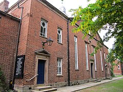
Fairfield Moravian Church
Greater Manchester UK location map 2.svg
Red pog.svg
Fairfield
Location within Greater Manchester
OS grid reference SJ901975
Metropolitan borough
Metropolitan county
Region
Country England
Sovereign state United Kingdom
Post town MANCHESTER
Postcode district M43
Dialling code 0161
Police Greater Manchester
Fire Greater Manchester
Ambulance North West
UK Parliament
List of places
UK
England
Greater Manchester
53°28′26″N2°08′53″W / 53.474°N 2.148°W / 53.474; -2.148 Coordinates: 53°28′26″N2°08′53″W / 53.474°N 2.148°W / 53.474; -2.148

Fairfield is a suburb near Droylsden in Tameside, Greater Manchester, England. Historically in Lancashire, it is just south of the Ashton Canal on the A635 road. In the 19th century, it was described as "a seat of cotton manufacture". [1] W. M. Christy and Sons established a mill that produced the first woven towels in England at Fairfield Mill. [2]

Fairfield is the location of Fairfield High School for Girls, Fairfield railway station and a place of worship. The community has been home to members of the Moravian Church for many years after Fairfield Moravian Church and Moravian Settlement were established in 1783. [3]

Notable people from Fairfield include the artist Arthur Hardwick Marsh (1842-1909), and the merchant banker and art collector, Robin Benson (1850–1929). [4]

Related Research Articles

Fairfield may refer to:

Tameside Borough of Greater Manchester, England

The Metropolitan Borough of Tameside is a metropolitan borough of Greater Manchester in England. It is named after the River Tame, which flows through the borough, and includes the towns of Ashton-under-Lyne, Audenshaw, Denton, Droylsden, Dukinfield, Hyde, Mossley and Stalybridge. Its western border is approximately 4 miles (6.4 km) east of Manchester city centre. Tameside is bordered by the metropolitan boroughs of Stockport and Oldham to the south and north respectively, the city of Manchester to the west and the borough of High Peak in Derbyshire to the east across Longdendale. As of 2011 the overall population was 219,324. It is also the 8th-most populous borough of Greater Manchester by population.

Stalybridge Human settlement in England

Stalybridge is a town in Tameside, Greater Manchester, England, with a population of 23,731 at the 2011 Census. Historically part of Cheshire, it is 8 miles (12.9 km) east of Manchester city centre and 6 miles (9.7 km) north-west of Glossop.

Ashton-under-Lyne Town in Greater Manchester, England

Ashton-under-Lyne is a market town in Tameside, Greater Manchester, England. The population was 45,198 at the 2011 census. Historically in Lancashire, it is on the north bank of the River Tame, in the foothills of the Pennines, 6.2 miles (10.0 km) east of Manchester.

Dukinfield Town in Greater Manchester, England

Dukinfield is a town in Tameside, Greater Manchester, England, on the south bank of the River Tame opposite Ashton-under-Lyne, 6.3 miles (10.1 km) east of Manchester. At the 2011 Census, it had a population of 19,306.

Mossley Human settlement in England

Mossley (/ˈmɒzli/) is a town and civil parish in Tameside, Greater Manchester, England, in the upper Tame Valley and the foothills of the Pennines, 3 miles (4.8 km) southeast of Oldham and 8.9 miles (14.3 km) east of Manchester.

Droylsden Human settlement in England

Droylsden is a town in Tameside, Greater Manchester, England, 4.1 miles (6.6 km) east of Manchester city centre and 2.2 miles (3.5 km) west of Ashton-under-Lyne, with a population at the 2011 Census of 22,689.

Haughton Green Human settlement in England

Haughton Green is a large village in Tameside, Greater Manchester, England. It formed part of the ancient township of Haughton, Lancashire, along with Haughton Dale, Higher Haughton, Lower Haughton, Haughton Hall and Haughton itself.

Fairfield railway station (England) Railway station in Greater Manchester, England

Fairfield railway station serves the Fairfield area of Droylsden, Tameside, Greater Manchester and is 3.1 miles (5 km) east of Manchester Piccadilly station. It was opened by the Manchester, Sheffield & Lincolnshire Railway in 1892, when the branch to Chorlton-cum-Hardy opened, and replaced an earlier station that had opened with the line in 1841. The original station was west of the present site. For a suburban station, Fairfield has very low passenger usage.

Charles Hindley (politician)

Charles Hindley was an English cotton mill-owner and Radical politician who sat as Member of Parliament for Ashton-under-Lyne, Lancashire from 1835 until his death in 1857. He was active in the Factory Reform movement, in the opposition to the New Poor Law, and in opposition to state involvement in religious and educational matters, but was rarely prominent in them, being more sought after as a chairman of meetings than as a speaker at them, and too inclined to moderation and compromise to be accepted as a reliable leader. He was the first member of the Moravian Church to be a British member of parliament. A portrait of Hindley is in the collection of the National Portrait Gallery, London

Fairfield High School for Girls, is an all-girls' secondary academy located in Droylsden, Greater Manchester.

Whit Friday

Whit Friday, meaning "white Friday", is the name given to the first Friday after Pentecost or Whitsun.

Westwood Moravian Church

Westwood Moravian Church was founded in 1865 in the Westwood area of Oldham, in Greater Manchester, England. By 1868 the church building was too small for its congregation, and a new structure was opened in 1869. This church was used for Moravian services until 2005 when the congregation sold it and moved to its new premises in Royton. The Westwood building still stands.

Fairfield Moravian Church

Fairfield Moravian Church and its surrounding settlement was founded in 1785 in Fairfield, Droylsden, Lancashire, England. It was founded by Benjamin La Trobe as a centre for evangelistic work for the Moravian Church in the Manchester area. Numbers 15, 28 and 30 Fairfield Square are Grade II* listed buildings.

Salem Moravian Church was founded in Oldham, Lancashire, England in 1825 by John Lees. Br Lees, who lived in the Clarksfield area of Oldham, was associated with the Moravian Settlement at Fairfield in Droylsden.

Dukinfield Moravian Church was founded in Dukinfield, Cheshire, England in 1755 following a period of evangelistic work in the area by Moravians from 1742. It now stands within the Tameside Metropolitan Borough, Greater Manchester.

Saxon Mill, Droylsden Cotton mill in Greater Manchester, England

Saxon Mill, Droylsden was a cotton spinning mill in Droylsden, Tameside, Greater Manchester, England. It was built in the 1907, taken over by the Lancashire Cotton Corporation in the 1930s and passed to Courtaulds in 1964. Production finished in 1967, and the mill was demolished in 1995.

Christy (towel manufacturer)

Christy is a long-established manufacturer of household linens and is known as the inventor of the first industrially produced looped cotton (terrycloth) towel. It was founded in 1850 in the English mill town of Droylsden, Lancashire.

Droylsden is a town in Tameside, Greater Manchester, England. The town, together with its suburb of Littlemoss, contains 37 listed buildings that are recorded in the National Heritage List for England. Of these, three are listed at Grade II*, the middle grade, and the others are at Grade II, the lowest grade.

References

  1. Fairfield Lancashire, A Vision of Britain Through Time, retrieved 14 April 2012
  2. Droylsden and Fairfield. 1 miles E. from Manchester (p129), Graces Guide, retrieved 15 April 2012
  3. Township Information - Droylsden, Tameside Council, retrieved 15 April 2012
  4. Wake, Jehanne (5 May 2006). "Benson, Robert Henry [Robin]". Oxford Dictionary of National Biography . Retrieved 23 April 2020.