

The Fairstead Estate is a suburb of King's Lynn, Norfolk, England. The population of Fairstead ward of King's Lynn and West Norfolk Borough at the 2011 Census was 6,479. [1]
The Fairstead Estate is a suburb of King's Lynn, Norfolk, England. The population of Fairstead ward of King's Lynn and West Norfolk Borough at the 2011 Census was 6,479. [1]
Fairstead has two schools, Fairstead Community Primary School, a very large primary school, and Churchill Park School, which was completed in 2010 and is a merger of Alderman Jackson and Ethel Tipple Schools.
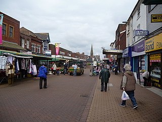
Fairstead has its own minor shopping zone, called Centre Point, with a doctor's surgery, a chemist,Morrisons, a chip chop and a charity shop. The Fairstead Community Centre is also situation at the Centre Point. It offers a Main Hall, a small car park (as is getting new houses built on) [2] At the other end of the estate there is a convenience store.
The pub has been knocked down as the residents complained of it being an eyesore this was done through the Borough Council of King's Lynn & West Norfolk and West Norfolk police safer neighbourhood teams. This has since been made into flats.

The London Borough of Havering in East London, England, forms part of Outer London. It has a population of 259,552 inhabitants; the principal town is Romford, while other communities are Hornchurch, Upminster, Collier Row and Rainham. The borough is mainly suburban, with large areas of protected open space. Romford is a major retail and night time entertainment centre, and to the south the borough extends into the London Riverside redevelopment area of the Thames Gateway. The name Havering is a reference to the Royal Liberty of Havering which occupied the area for several centuries. The local authority is Havering London Borough Council. It is the easternmost London borough.
Sandwell is a metropolitan borough of the West Midlands county in England. The borough is named after the Sandwell Priory, and spans a densely populated part of the West Midlands conurbation. According to Sandwell Metropolitan Borough Council, the borough comprises the six amalgamated towns of Oldbury, Rowley Regis, Smethwick, Tipton, Wednesbury, and West Bromwich, although these places consist of numerous smaller settlements and localities.

King's Lynn and West Norfolk is a local government district with borough status in Norfolk, England. Its council is based in the town of King's Lynn. The population of the district at the 2011 census was 147,451.
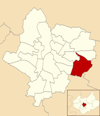
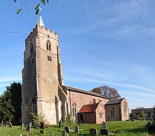
Evington is an area of Leicester, and electoral ward of the Leicester district, in the ceremonial county of Leicestershire, England. It used to be a small village centred on Main Street and the Anglican church of St Denys but was close enough to Leicester to become one of the outer suburbs in the 1930s. Today, the ward comprises the historical village of Evington, as well as the modern ex-council estates of Rowlatts Hill and Goodwood. The population of the ward at the 2011 census was 11,133.

Eastwood is a former coal mining town in the Broxtowe district of Nottinghamshire, England, 8 miles (13 km) northwest of Nottingham and 10 miles (16 km) northeast of Derby on the border between Nottinghamshire and Derbyshire. Mentioned in Domesday Book, it expanded rapidly during the Industrial Revolution. The Midland Railway was formed here and it is the birthplace of D. H. Lawrence. The distinctive dialect of East Midlands English is extensively spoken, in which the name of the town is pronounced.

The Metropolitan Borough of Dudley is a metropolitan borough of West Midlands, England. It was created in 1974 following the Local Government Act 1972, through a merger of the existing Dudley County Borough with the municipal boroughs of Stourbridge and Halesowen.

Downham is a district of south-east London, England, within the London Borough of Lewisham. It borders the London Borough of Bromley, and is located north of Bromley and south of Catford.
Gamston is a ward, civil parish and a suburb of West Bridgford, in the Rushcliffe district of Nottinghamshire, England. The population of the civil parish at the 2011 census was 2,164. It is situated approximately 3 miles (5 km) south-east of Nottingham and is part of the West Bridgford/Meadows/Sneinton postcode of NG2.

Bewbush is one of 14 neighbourhoods in Crawley in West Sussex, England. Bewbush is located in south west Crawley and is bordered by Broadfield to the south, Ifield to the north, Kilnwood Vale to the west and Gossops Green to the north east. The neighbourhood has a population of approximately 9,000.

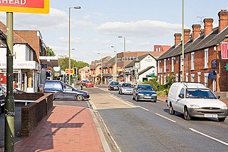
Calcot, or Calcot Row, is a former village, now a suburb west of Reading in Berkshire, England. Calcot straddles the historic A4 Bath Road and is between the former hamlet of Horncastle, and Junction 12 of the M4. Tilehurst is to the north, and the village of Theale is to the west, across the motorway. Its named neighbourhoods include Beansheaf Farm and Fords Farm south of the centre developed in the early 21st century.

Beaumont Leys is a suburb and electoral ward in north-western Leicester, in the Leicester district, in the ceremonial county of Leicestershire, England. The population of the ward at the 2011 census was 16,480. Locally, Beaumont Leys is usually used in reference to the large housing estate, built within the administrative division, centred on Strasbourg Drive.
Chandler's Ford is a largely residential area and civil parish in the Borough of Eastleigh in Hampshire, England. It has a population of 21,436 in the 2011 UK Census.
Compton Acres is a housing development located to the south west of West Bridgford, Nottinghamshire, England, on the rural-urban fringe. Compton Acres also borders with the villages of Ruddington and Wilford. Most of the estate was built in the 1990s.

Brickhill is a civil parish and electoral ward within northern Bedford in Bedfordshire, England.
West Lynn is a village and former civil parish, now in the unparished area of King's Lynn, in the King's Lynn and West Norfolk district, in the county of Norfolk, England. It is west of the River Great Ouse, linked to the main part of King's Lynn by the King's Lynn passenger ferry or by a circuitous 4 km road journey.

Hatch Warren is a district and ward of Basingstoke in Hampshire, England. The population of the appropriate ward called Hatch Warren and Beggarwood was 9,284 at the 2011 Census. It is situated west of the town centre and neighbouring housing estates include Kempshott and Brighton Hill. It is primarily served by Brighton Hill Community School, one Primary school, St Marks and a junior school, Hatch Warren.
Putnoe is an electoral ward on the northern side of Bedford, England.

Gaywood is an eastern area of the town of King's Lynn, in the unparished area of King's Lynn, in the King's Lynn and West Norfolk district, in the county of Norfolk, England.

Goldington is a district, ward and unparished area of Bedford, Bedfordshire, England. It encompasses much of the historic village and parish of Goldington that was merged with Bedford in 1934, although some parts of the old village are within the neighbouring Newnham ward. It also includes two modern estates that are part of Renhold parish.

Kingsbrook is an electoral ward and area within the town of Bedford, England.