Related Research Articles

Insh Marshes are an area of floodplain of the River Spey between Kingussie and Kincraig in Badenoch and Strathspey, Highland, Scotland. The marshes are said to be one of the most important wetlands in Europe. They lie at altitude of approximately 240 to 220 m above sea level, and form one of the largest areas of floodplain mire and fen vegetation in Scotland.
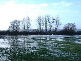
Walmore Common is a 57.78-hectare (142.8-acre) nature reserve on the flood-plain of the River Severn, west of the city of Gloucester in England and north of the village of Chaxhill. It was notified as a biological Site of Special Scientific Interest in 1966. The site is listed in the 'Forest of Dean Local Plan Review' as a Key Wildlife Site (KWS).

Cuilcagh is a mountain on the border between County Fermanagh and County Cavan. With a height of 665 metres (2,182 ft) it is the highest point in both counties. It is also the 170th highest peak on the island of Ireland, and Ireland's only cross-border county top. Water from the southern slope flows underground until it emerges some miles away in the Shannon Pot, the traditional source of the River Shannon. The area is sometimes referred to as the Cuilcagh Mountains.

The Ythan Estuary is the tidal component of the Ythan River, emptying into the North Sea 19 kilometres (12 mi) north of Aberdeen, Scotland. The estuary’s tidal action extends a 7 kilometres (4.3 mi) inland and has characteristic widths of between 250 metres (820 ft) and 780 metres (2,560 ft). Besides the tidal channel there are interfaces to the upland dunes including mudflats, sand beaches and shingle flats. Reaches of salt marsh occur, but they are primarily near the Waterside Bridge and the mouth of the Tarty Burn, a small tributary river. Based upon the habitat of the moorland bordering the east of the Ythan River near the mouth, this estuary is the most significant coastal moorland in the northern United Kingdom.
Slieve Beagh or Sliabh Beagh is a mountainous area straddling the border between County Monaghan in the Republic of Ireland and County Fermanagh and County Tyrone in Northern Ireland. A point just east of its summit is the highest point in Monaghan; however the true summit is on the Fermanagh-Tyrone border. The point where the three counties meet, is referred to as the "Three County Hollow".
Thursley Common is a National nature reserve in Surrey, England, and has also been designated as a Ramsar wetland. It is also part of a Site of Special Scientific Interest called Thursley, Hankley and Frensham Commons.
Claish Moss is an upland blanket bog on the south side of Loch Shiel, in the Sunart district of the west highlands of Scotland

Forsinard Flows is a national nature reserve (NNR) covering much of the area surrounding Forsinard in the Highland council area of Scotland. It lies at the heart of the Flow Country, a large, rolling expanse of peatland and wetland area of Caithness and Sutherland that makes up almost 5% of the world's blanket bog. The reserve is managed by the Royal Society for the Protection of Birds (RSPB), and is designated a Category II protected area by the International Union for Conservation of Nature. Much of the NNR overlaps with the designated area of the Caithness and Sutherland Peatlands Special Protection Area and Special Area of Conservation.

Many parts of Scotland are protected in accordance with a number of national and international designations because of their environmental, historical or cultural value. Protected areas can be divided according to the type of resource which each seeks to protect. NatureScot has various roles in the delivery of many environmental designations in Scotland, i.e. those aimed at protecting flora and fauna, scenic qualities and geological features. Historic Environment Scotland is responsible for designations that protect sites of historic and cultural importance. Some international designations, such as World Heritage Sites, can cover both categories of site.
A' Mhòine is a peninsula in the Highlands, Scotland. The peninsula is bounded to the west by Loch Eriboll, and to the east by the Kyle of Tongue. The A838 road crosses the peninsula on an east–west axis. Much of the peninsula is owned by Melness Estate on behalf of 59 crofters.

The Caithness and Sutherland Peatlands is a large area of blanket bog and peatland, covering a number of disconnected regions across the historic counties of Caithness and Sutherland in the far north of Scotland, across an area known as the Flow Country. With a total area of 143,503 hectares, it is one of the largest recognised conservation sites in the UK, and is the largest Ramsar Site in Scotland.

The Kintyre Goose Roosts are a group of five oligotrophic hill lochs on the Kintyre peninsula in Argyll and Bute, western Scotland. With a total area of 312 hectares, they have been protected as a Ramsar Site since 1998.
Greenlaw Moor is an area of raised heather moorland in the foothills of the Lammermuir Hills, in the Scottish Borders area of Scotland. Located north of the town of Greenlaw and with an area of 248 hectares, the moor has been protected as a Ramsar Site since 1996.
Eilean na Muice Duibhe, also known as Duich Moss, is an area of low-level blanket mire on the island of Islay, off the west coast of Scotland. Located south of the town of Bowmore and with an area of 576 hectares, the area has been protected as a Ramsar Site since 1988.
Lewis Peatlands is a large area of blanket bog covering more than one third of the Isle of Lewis, off the west coast of Scotland. With a total area of 58,984 hectares, it is one of the largest and most intact known areas of blanket bog in the world, and is the second largest Ramsar site in Scotland.
Loch an Duin is a complex system of freshwater, brackish and sea lochs, tidal channels and islands, on and close to North Uist off the west coast of Scotland. An area of 2,621 hectares has been protected since 1990 as a Ramsar Site.

Silver Flowe is an area of patterned blanket mire in the Galloway Hills, in Dumfries and Galloway, Scotland. Located around 16km north northeast of Newton Stewart, it forms part of the Galloway Forest Park. An area of 620 hectares has been designated as a Ramsar Site.

South Tayside Goose Roosts is a composite wetland site to the west of Perth in central Scotland, covering a total of 331 hectares, which has been protected as a Ramsar Site since 1993. Incorporating three disconnected sections, separated by several kilometres, the site contains seven freshwater lochs along with other wetland habitats, including one of the largest raised bogs in the region.

The South Uist Machair and Lochs is a protected wetland area on the west coast of South Uist in the Outer Hebrides of Scotland. A total of 5,019 hectares contains blanket bog, oligotrophic lochs, wet and dry machair, fresh and saltwater marsh, coastal dunes and sandy and rocky shores. It includes the estuary waters of the Howmore River, as well as Loch Bi and Loch Druidibeg. It has been protected as a Ramsar Site since 1976.
References
- 1 2 "Fala Flow SPA". Joint Nature Conservation Committee. Retrieved 27 February 2019.
- 1 2 "Fala Flow". Ramsar Sites Information Service. Retrieved 27 February 2019.
- ↑ "UK Fala Flow 13015 RIS 2005" (PDF). Ramsar Sites Information Service. Retrieved 27 February 2019.
- ↑ "Fala Flow SSSI". Scottish Natural Heritage. Retrieved 27 February 2019.