Hinds County is a county located in the U.S. state of Mississippi. With its county seats, Hinds is the most populous county in Mississippi with a 2020 census population of 227,742 residents. Hinds County is a central part of the Jackson metropolitan statistical area. It is a professional, educational, business and industrial hub in the state. It is bordered on the northwest by the Big Black River and on the east by the Pearl River. It is one county width away from the Yazoo River and the southern border of the Mississippi Delta.

Meridian is the eighth most populous city in the U.S. state of Mississippi, with a population of 35,052 at the 2020 census. It is the county seat of Lauderdale County and the principal city of the Meridian, Mississippi Micropolitan Statistical Area. Along major highways, the city is 93 mi (150 km) east of Jackson; 154 mi (248 km) southwest of Birmingham, Alabama; 202 mi (325 km) northeast of New Orleans, Louisiana; and 231 mi (372 km) southeast of Memphis, Tennessee.

Liberty is a town in Amite County, Mississippi. It is part of the McComb, Mississippi micropolitan statistical area. It is the county seat of Amite County.

Clarksdale is a city in and the county seat of Coahoma County, Mississippi, United States. It is located along the Sunflower River. Clarksdale is named after John Clark, a settler who founded the city in the mid-19th century when he established a timber mill and business. Clarksdale is in the Mississippi Delta region and is an agricultural and trading center. Many African-American musicians developed the blues here, and took this original American music with them to Chicago and other northern cities during the Great Migration.
Mayersville is a town on the east bank of the Mississippi River, and the county seat for Issaquena County, Mississippi, United States. It is located in the Mississippi Delta region, known for cotton cultivation in the antebellum era. Once the trading center for the county, the town was superseded when railroads were built into the area. The population of the majority-black town was 547 at the 2010 census, down from 795 at the 2000 census.

Oxford is the 14th most populous city in Mississippi, and the county seat of Lafayette County, 75 miles (121 km) southeast of Memphis. A college town, the University of Mississippi or "Ole Miss" is adjacent to the city. Founded in 1837, it is named for Oxford, England.

Hattiesburg is the 5th most populous city in the U.S. state of Mississippi, located primarily in Forrest County and extending west into Lamar County. The city population was 45,989 at the 2010 census, with the population now being 48,730 in 2020. Hattiesburg is the principal city of the Hattiesburg Metropolitan Statistical Area, which encompasses Covington, Forrest, Lamar, and Perry counties. The city is located in the Pine Belt region.
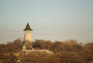
Prospect Park is a historic neighborhood within the University community of the U.S. city of Minneapolis, Minnesota. The area is bounded by the Mississippi River to the south, the City of Saint Paul, Minnesota to the east, the Burlington Northern railroad yard to the north, and the Stadium Village commercial district of the University of Minnesota to the west. The neighborhood is composed of several districts which include the East River Road area. The 1913 Prospect Park Water Tower is a landmark and neighborhood icon.

Haughville is a neighborhood west of downtown Indianapolis. Its borders are roughly White River Parkway to the east, Tibbs Avenue to the west, 16th Street to the north, and Michigan Street to the south. It was first settled in the 1830s and grew after a bridge over White River was built connecting to Indianapolis, which annexed the town in 1897. The modern version of the bridge is also the connection between Haughville on the west side of the river and the Sidney & Lois Eskenazi Hospital and Indiana University - Purdue University Indianapolis on the east. The population in the late 1890s included Slovenian, German, and Irish immigrants, among other European immigrants. In the 21st century, the neighborhood suffers from a high crime rate and low property values.

Uptown is a section of New Orleans, Louisiana, United States, on the east bank of the Mississippi River, encompassing a number of neighborhoods between the French Quarter and the Jefferson Parish line. It remains an area of mixed residential and small commercial properties, with a wealth of 19th-century architecture. It includes part or all of Uptown New Orleans Historic District, which is listed on the National Register of Historic Places.

America's 11 Most Endangered Places or America's 11 Most Endangered Historic Places is a list of places in the United States that the National Trust for Historic Preservation considers the most endangered. It aims to inspire Americans to preserve examples of architectural and cultural heritage that could be "relegated to the dustbins of history" without intervention.
Henry Columbus Speir was an American "talent broker" and record store owner from Jackson, Mississippi. He was responsible for launching the recording careers of most of the greatest Mississippi blues musicians in the 1920s and 1930s. According to blues researcher Gayle Dean Wardlow, "Speir was the godfather of Delta Blues" and was "a musical visionary [without whom] Mississippi's greatest natural resource might have gone untapped." A historical marker commemorates his life and work.

Mississippi Highway 35 is a state highway in Mississippi. It runs north–south for 274.7 miles (442.1 km), beginning at the Louisiana state line and ending at a junction with MS 315 at Sardis Dam. MS 35 serves the counties of Marion, Jefferson Davis, Covington, Smith, Scott, Leake, Attala, Carroll, Grenada, Tallahatchie, and Panola.

Trumpet Records was an American record company founded by Lillian McMurry in Jackson, Mississippi in 1951. Although it existed for only four years, it was influential.

There are nine historic districts in Meridian, Mississippi. Each of these districts is listed on the National Register of Historic Places. One district, Meridian Downtown Historic District, is a combination of two older districts, Meridian Urban Center Historic District and Union Station Historic District. Many architectural styles are present in the districts, most from the late 19th century and early 20th century, including Queen Anne, Colonial Revival, Italianate, Art Deco, Late Victorian, and Bungalow.
The South Campus Historic District is a historic district in Chico, California which was named to the National Register of Historic Places in 1991 through efforts of the Chico Heritage Association. The district is situated entirely within the South Campus Neighborhood. The historical district extends from Salem Street to Cherry Street, and from West Second Street to West Sixth Street. Whereas, the neighborhood extends from West Second Street south to West Ninth Street and west from Salem Street all the way to the city limits, which, in that area, is called the "Green Line." The South Campus Neighborhood Association represents the interests of the neighborhood to the community. There are several fraternity and sorority houses in the area, and the city has designated the South Campus Fraternity/Sorority Overlay Zone which is largely contiguous with the neighborhood and district.

The Greyhound Bus Station at 219 N. Lamar St., Jackson, Mississippi, was the site of many arrests during the May 1961 Freedom Rides of the Civil Rights Movement. The Art Deco building has been preserved and currently functions as an architect's office.
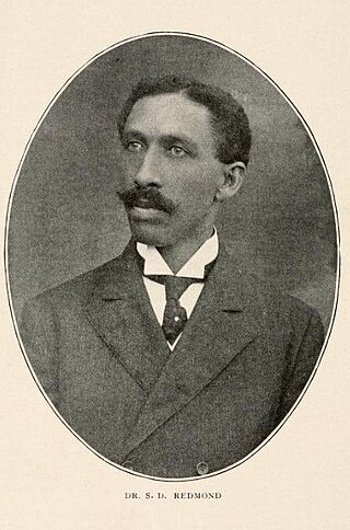
Sidney Dillon Redmond was an American civic leader, physician, lawyer, and politician from Jackson, Mississippi. He was an important African American community leader and headed the Mississippi Republican Party as part of the "black-and-tan" faction. Later in his career (1910) he became a lawyer. His son Sidney Revels Redmond, was a Harvard University Law School graduate, and lawyer; he shared a law practice with his son in Jackson, starting in 1926.
W. L. Mhoon, also known as William L. Moon (1879–1950), was an American lawyer and politician in Jackson, Mississippi. He was one of two African American lawyers licensed in the state of Mississippi in the mid-1940s. Mhoon was a black-and-tan member of the Mississippi Republican Party.

