Farnetta

Last updated
Farnetta
Castrum Farnectae
FarnettaMontecastrilli7.jpg
Italy provincial location map 2016.svg
Red pog.svg
Farnetta
Location of Farnetta in Italy
Coordinates: 42°40′N12°30′E / 42.667°N 12.500°E / 42.667; 12.500
CountryFlag of Italy.svg  Italy
Region UMB
Province TR
Comune Montecastrilli
Elevation
385 m (1,263 ft)
Population
 (31 August 2007)
  Total283
Demonym Farnettani
Time zone UTC+1 (CET)
  Summer (DST) UTC+2 (CEST)
Postal code
05026
Dialing code 0744
Patron saint St. Rita
Saint dayMay 22
Website Official website

Farnetta is a small village in the Terre Arnolfe countryside, 16 miles northwest of the Italian city of Terni, Umbria. It is included in the comune of Montecastrilli in the province of Terni (central Italy). It has a population of 283.

Contents

Farnetta derives its name from the old Latin name Quercus Frainetto. It is reputed to be one of Umbria's smallest villages. It has several farms and houses, and a church, dedicated to St Nicolaus, which has its origins in the 16th century but underwent heavy restoration in 1855-1870. The church has been designated by Italian Heritage.[ clarification needed ]

On a nearby hill are the remains of a Medieval hill fort known as Palombara, and the 10th- to 11th-century Romanesque Church of San Lorenzo in Nifili. San Lorenzo was built on the remains of a Roman building, and incorporates large stone blocks from that building. The church is located on an important Roman road (Via Amerina) connecting Amelia to Todi and Perugia.

History

It is likely that the area was also inhabited in the Iron Age and throughout the Roman period. Close to the Roman roads Amerina and Flaminia, the area has numerous elements of early Roman infrastructure, indicating that it was extensively settled.

The village's name's is traditionally connected to the toponym Quercus frainetto , a species of oak.

The territory where Farnetta will be constructed centuries later, was near the borders of three Roman cities: Todi, Carsulae and Amelia. After the fall of the Roman empire, the territory was devastated by barbaric invasions and people moved to live in the oak forests. The village of Farnetta was likely founded in the 9-10th century during the encastellation times.

The village was later part of the Terre Arnolfe, under the feudal rule of the Arnolfi family, and later subjected to Todi and Terni. The church of Farnetta was listed in the Farfa Abbey register in 1112.

Following the fall of the Arnolfi rule, the territory of Farnetta passed under the jurisdiction of the comune of Todi, but again it was on the border with the territories of other cities. In medieval times, the small village was circled with stone walls to protect inhabitants from attacks by the nearby cities of Amelia and Narni.

Farnetta become part in 1367 of the Papal States, and it remained subject to it till 1860, apart for small periods of time (Napoleonic period). It was in the religious jurisdiction of the bishop of Todi.

In 1817, the administrative jurisdiction of Farnetta passed from Todi to Terni.

Main sights

Farnetta is 385 meters above sea level. The Farnetta Natural Park is a protected area (Zona di ripopolamento e cattura) that covers a part of the village. Trails cross the park.

Its historical center was once surrounded by medieval walls. Most of them have been dismantled, leaving only short stretches and a few cylindrical towers that served as part of the town's defenses.

The church of San Nicolo (Nicolaus), in the old part of the village, was begun in the 16th century and completed in the 19th century by the Nevi family. It includes 17th- and 18th-century paintings.

The small rural church of Santa Lucia has been recently restored: this church dates back to 17th century and it is connected with the medioval cult of St. Lucy, patron saint of the blind and those suffering from eyes problems,and St. Apollonia, the patroness of dentistry and those suffering from toothache. The church includes an important oil painting from the 17th century.

Dunarobba Fossil Forest

The Fossil Forest of Dunarobba, 3 km from Farnetta, is one of the world's oldest forests. Two million years ago, the oceans withdrew from the area, leaving an ancient lake, Tiberino. Water runoff from the emerging hills and mountains carried large quantities of sediments which, along with tectonic movements, covered the forest's giant trees and preserved them.

San Lorenzo in Nifili

The listed Church of San Lorenzo (10th century) is located in the parish territory of Farnetta (2 km from Farnetta). This is described as 'almost unique for its architectural heritage and level of preservation' owing to its stone barrel vault, which runs the length of the nave and medieval frescoes. The church has been constructed over a Roman temple and a significant amount of Roman stone blocks and artefacts have been reused for the construction of this church.

Culture

Farnetta is known for its Feast of St. Rita, held the last week of May. During the feast, local residents organize a trattoria with traditional food.

In the nearby medieval church of S. Lorenzo (st. Lawrence), on the 10th of August, every year, a historic religious feast is celebrated with local food and wine.

Other medieval towns and villages are present near Farnetta: Todi (17 km), Sangemini, (10 km), Spoleto (42 km), Carsulae (12 km) and Orvieto (38 km).

Transport

Farnetta is served by Bus Italia services to Terni, Todi, Sangemini, Montecastrilli, Avigliano and Amelia.

Economy

Agriculture was important for Farnetta's rural development and poverty reduction. Today the village has made use of its past and created a tourist industry; many people enjoy agriturismi (farm holidays) in the area.

Demography

The population of the civil parish, recorded in the 2001 census, is 246. In the 13th century the population was about 500 (96 fireplaces). [1]

List of people from Farnetta

Related Research Articles

<span class="mw-page-title-main">Umbria</span> Region of Italy

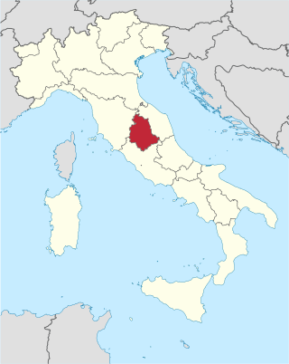
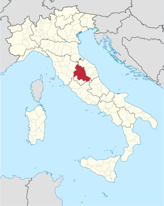
Umbria is a region of central Italy. It includes Lake Trasimeno and Marmore Falls, and is crossed by the river Tiber. It is the only landlocked region on the Apennine Peninsula. The regional capital is Perugia.

Via Flaminia Ancient Roman road

The Via Flaminia or Flaminian Way was an ancient Roman road leading from Rome over the Apennine Mountains to Ariminum (Rimini) on the coast of the Adriatic Sea, and due to the ruggedness of the mountains was the major option the Romans had for travel between Etruria, Latium, Campania, and the Po Valley. The section running through northern Rome is where Constantine the Great had his famous vision of the Chi Rho, leading to his conversion to Christianity and the Christianization of the Roman Empire.

<span class="mw-page-title-main">Province of Terni</span> Province of Italy

The Province of Terni is the smaller of the two provinces in the Umbria region of Italy, comprising one-third of both the area and population of the region. Its capital is the city of Terni. The province came into being in 1927, when it was carved out of the original unitary province of Umbria.

<span class="mw-page-title-main">Province of Perugia</span> Province of Italy

The Province of Perugia is the larger of the two provinces in the Umbria region of Italy, comprising two-thirds of both the area and population of the region. Its capital is the city of Perugia. The province covered all of Umbria until 1927, when the province of Terni was carved out of its southern third. The province of Perugia has an area of 6,334 km² covering two-thirds of Umbria, and a total population of about 660,000. There are 59 comunes in the province. The province has numerous tourist attractions, especially artistic and historical ones, and is home to the Lake Trasimeno, the largest lake of Central Italy. It is historically the ancestral origin of the Umbri, while later it was a Roman province and then part of the Papal States until the late 19th century.

<span class="mw-page-title-main">Trevi, Umbria</span> Comune in Umbria, Italy

Trevi is an ancient town and comune (municipality) in Umbria, Italy, on the lower flank of Mount Serano overlooking the wide plain of the Clitunno river system. Located in the Province of Perugia, it is 10 km (6 mi) SSE of Foligno and 20 km (12 mi) north of Spoleto. It is a member of the I Borghi più belli d'Italia association.

<span class="mw-page-title-main">Cascia</span> Comune in Umbria, Italy

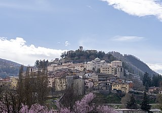
Cascia is a town and comune (municipality) of the Italian province of Perugia in a rather remote area of the mountainous southeastern corner of Umbria. It is about 21 km from Norcia on the road to Rieti in the Lazio (63 km). It is also very close to Terni.

<span class="mw-page-title-main">Bettona</span> Comune in Umbria, Italy

Bettona is an ancient town and comune of Italy, in the province of Perugia in central Umbria at the northern edge of the Colli Martani range. It is 5 km (3 mi) E of Torgiano and 12 km (7 mi) SW of Assisi. It is a member of the I Borghi più belli d'Italia association. Passaggio, Colle and Cerreto are frazioni of the comune.

<span class="mw-page-title-main">Carsulae</span> Archeological site in Italy

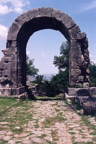
Carsulae is an archaeological site in the region of Umbria in central Italy. It is located approximately 4 kilometres (2.5 mi) north of San Gemini, a small comune in the province of Terni.

<span class="mw-page-title-main">Amelia, Umbria</span> Comune in Umbria, Italy

Amelia is a town and comune of the province of Terni, in the Umbria region of central Italy. It grew up around an ancient hill fort, known to the Romans as Ameria.

<span class="mw-page-title-main">Acquasparta</span> Comune in Umbria, Italy

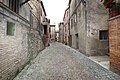
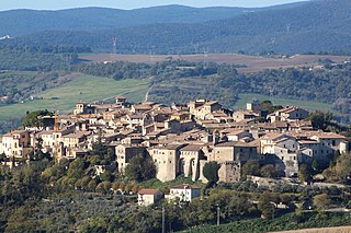
Acquasparta is a town and comune in the province of Terni. It is located on a hill above the Naia Valley and the river of the same name, facing the Monti Martani mountain range. It is a member of the I Borghi più belli d'Italia association. It also sits between two hot springs, the Amerino and the Furapane.

<span class="mw-page-title-main">Ferentillo</span> Comune in Umbria, Italy

Ferentillo is a comune (municipality) in the Province of Terni in the Italian region Umbria, located about 60 km southeast of Perugia and about 12 km northeast of Terni. The comune, located in the valley of the Nera, is divided by the river into the burghs of Matterella and Precetto.

<span class="mw-page-title-main">Montecastrilli</span> Comune in Umbria, Italy

Montecastrilli is a comune (municipality) in the Province of Terni in the Italian region of Umbria, located about 50 km south of Perugia and about 15 km northwest of Terni.

Montecchio is a comune (municipality) in the Province of Terni in the Italian region Umbria, located about 50 km south of Perugia and about 30 km northwest of Terni.

<span class="mw-page-title-main">San Gemini</span> Comune in Umbria, Italy

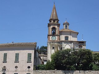
San Gemini is a comune (municipality) of c. 5,000 inhabitants in the province of Terni in the Italian region Umbria, located about 60 km south of Perugia and about 10 km northwest of Terni.

<span class="mw-page-title-main">Avigliano Umbro</span> Comune in Umbria, Italy

Avigliano Umbro is a comune (municipality) in the Province of Terni in the Italian region Umbria, located about 50 km south of Perugia and about 20 km northwest of Terni. As of 2011 census its population was of 2,568.

<span class="mw-page-title-main">Cesi, Terni</span>

Cesi is a frazione of the Italian comune of Terni, in the province of Terni, southern Umbria, Italy. The small borgo, which retains its late-medieval aspect, set among olive groves, lies "stretched out lengthwise along a narrow contour on the slopes of M. Torre Maggiore," about 18 km north of Terni at an altitude of 437 m, one of the southernmost peaks of the Monti Martani. As of 2001 there were 682 residents.

<span class="mw-page-title-main">Todi Castle</span> Historic site in Umbria, Italy

The Todi Castle is a former medieval Castle located 15 km south of the town of Todi, to the east side of the town of Collelungo, which is part of the Municipality of Baschi, near Terni, in Umbria, Italy.

<span class="mw-page-title-main">Sismano</span>

Sismano, a little medieval borgo, is a frazione of the Italian commune of Avigliano Umbro, in the province of Terni. Sismano lies 13 km from Todi and 5 km from Avigliano; according to the Italian state census of 2001, Sismano has 17 inhabitants in the densely built historic center and 308 in all.

<span class="mw-page-title-main">San Lorenzo in Nifili</span>

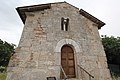
San Lorenzo in Nifili is a Romanesque-style, Roman Catholic church located near the village of Farnetta, part of the commune of Montecastrilli, in the province of Terni, region of Umbria, Italy.

<span class="mw-page-title-main">San Francesco, Amelia</span> Church in Amelia, Province of Terni. Umbria

San Francesco is a gothic-style, church located in the town of Amelia, Province of Terni, region of Umbria, Italy.

References

  1. Corradi, M., (2005), Castrum Farnectae: le famiglie, la storia, le cronache di un castello umbro, Del Gallo, Spoleto