Farrington Gurney

Last updated

Farrington Gurney
Farringtongurneychurch.jpg
Church of St John the Baptist
Somerset UK location map.svg
Red pog.svg
Farrington Gurney
Location within Somerset
Population901 (2011) [1]
OS grid reference ST629556
Unitary authority
Ceremonial county
Region
Country England
Sovereign state United Kingdom
Post town Bristol
Postcode district BS39
Dialling code 01761
Police Avon and Somerset
Fire Avon
Ambulance South Western
UK Parliament
Website www.farringtongurney.org
List of places
UK
England
Somerset
51°17′55″N2°31′58″W / 51.2987°N 2.5327°W / 51.2987; -2.5327

Farrington Gurney is a village and civil parish in Somerset, England located at the foot of the Mendip Hills on the junction of the A37 and A362. It has a population of 901. [1]

Contents

History

In the Domesday book, the village was known as Ferentone. [2] The second part of the name is believed to come from the Gournays, its ancient possessors, including Robert de Gournay in 1225. When Sir Thomas de Gournay was implicated in the murder of Edward II at Berkeley Castle, his estates were confiscated; Farrington was later annexed to the Duchy of Cornwall.

The parish was part of the hundred of Chewton. [3]

The manor house is believed to date from 1637, and the old parsonage from around 1700. [4]

Local industry included coal mining on the Somerset coalfield from around 1780 to sometime in the 1920s. [5]

An unmanned railway station, or "halt", existed in the village from 11 July 1927 to 2 November 1959, when the Bristol and North Somerset Railway line closed.

RAF Air Crash

On 17 September 1944 a Royal Air Force, Airspeed Horsa I (RJ113) was taking part in Operation Market Garden. While en-route the aircraft exploded which caused the tail to separate and the glider crashed near Farrington Gurney, killing the two pilots and all 21 paratroopers of the 9th Field Company RE (Airborne). [6] [7] [8]

Governance

Farrington Gurney's parish council is responsible for local issues, including setting an annual precept (local rate) to cover its operating costs, and producing annual accounts for public scrutiny. It evaluates local planning applications and works with the local police, district council officers, and neighbourhood watch groups on matters of crime, security and traffic. It initiates projects for the maintenance and repair of parish facilities, such as the village hall and community centre, playing fields and playgrounds, and consults with the district council on the maintenance, repair and improvement of highways, drainage, footpaths, public transport and street cleaning. It also addresses conservation and environmental matters, including trees and listed buildings.

An aerial view of the village FarringtonGurney.jpg
An aerial view of the village

The parish falls within the unitary authority of Bath and North East Somerset. Created in 1996 as established by the Local Government Act 1992, the authority provides a single tier of local government with responsibility for almost all local government functions within its area including local planning and building control, local roads, council housing, environmental health, markets and fairs, refuse collection, recycling, cemeteries, crematoria, leisure services, parks, and tourism. It is also responsible for education, social services, libraries, main roads, public transport, trading standards, waste disposal and strategic planning, although fire, police and ambulance services are provided jointly with other authorities through the Avon Fire and Rescue Service, Avon and Somerset Constabulary and the Great Western Ambulance Service.

Bath and North East Somerset's area covers part of the ceremonial county of Somerset but is administered independently of the non-metropolitan county. Its administrative headquarters is in Bath. Between 1 April 1974 and 1 April 1996, it was the Wansdyke district and the City of Bath of the county of Avon. [9] Before 1974, the parish was part of the Clutton Rural District. [10]

The parish is represented in the House of Commons of the Parliament of the United Kingdom as part of North East Somerset. [11] It elects one Member of Parliament (MP) by the "first past the post" election system. It was also part of the South West England constituency of the European Parliament, prior to Britain leaving the European Union in January 2020, which elected seven MEPs using the d'Hondt method of party-list proportional representation.

Education

There is a primary school in the village, Farrington Gurney Church of England Primary School.

Religious sites

The parish church is a small stone edifice dedicated to St John the Baptist. Originally of Norman architecture, it was rebuilt in Gothic style by John Pinch the younger in 1843. [4] The stump of the medieval cross and a carving over the door survive from an earlier building. [12] The church is set away from the main village in a picturesque location in the middle of a field, originally in order to protect the villagers from the plague.

The Methodist Church on the main A37/39 Road is part of the North East Somerset and Bath Circuit of Methodist Churches. Methodism started in the village around 1823, and the first building was near the site of the old village hall. The present church was built in 1880-1881 at a cost of £485, with a further £129 spent on furnishings. The land was negotiated from the Duchy of Cornwall by Colonel Mogg from Manor House. (As Mogg was an Anglican, it was a good early example of Ecumenism.) School rooms were added in 1909, and electric lighting in 1931. The last significant addition was the toilet and kitchen extension in 1971. The building is used extensively during the week by the Little Stars Nursery. Church members and friends meet for Coffee and Chat on Wednesday mornings, and morning worship is held every Sunday. [13]

Mineral Resources

Farrington Gurney Colliery operated from around 1738 until 1921. [14]

Sport

Farrington Gurney FC was founded in 1901 and officially joined the Somerset FA that year. Farrington joined the Mid-Somerset Football League in the 1961/62 season, and stayed with the league for four seasons before moving to the Bristol League. The 1975/76 season saw Farrington Gurney switch back to the Mid-Somerset League from the Bristol Suburban League going straight into Division 2. After winning promotion in style, the next few seasons saw Farrington Gurney struggle in the Premier Division, finishing 7th (1976/77), bottom (1977/78) and again bottom (1978/79). They were relegated to the First Division in 1979 and finished 4th that season. Farrington Gurney finished the 1990 season well by getting promoted back to the First Division. The Farrington Gurney Football Club play in Division 2 East of the Somerset County League. [15]

Related Research Articles

<span class="mw-page-title-main">Bath and North East Somerset</span> District in England

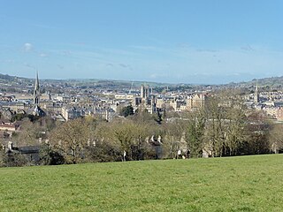
Bath and North East Somerset (B&NES) is a unitary authority district in Somerset, South West England. Bath and North East Somerset Council was created on 1 April 1996 following the abolition of the county of Avon. It is part of the ceremonial county of Somerset.

<span class="mw-page-title-main">Radstock</span> Human settlement in England

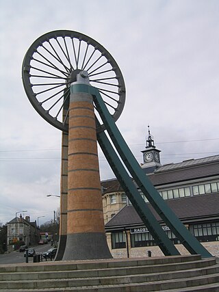
Radstock is a town and civil parish on the northern slope of the Mendip Hills in Somerset, England, about 9 miles (14 km) south-west of Bath and 8 miles (13 km) north-west of Frome. It is within the area of the unitary authority of Bath and North East Somerset. The Radstock built-up area had a population of 9,419 at the 2011 Census.

<span class="mw-page-title-main">Pensford</span> Human settlement in England

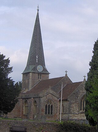
Pensford is the largest village in the civil parish of Publow in Somerset, England. It lies in the Chew Valley, approximately 7 miles (11 km) south of Bristol, 8 miles (13 km) west of Bath, and 14 miles (23 km) north of Wells. It is on the A37 road from Bristol to Shepton Mallet.

<span class="mw-page-title-main">Chilcompton</span> Human settlement in England

Chilcompton is a village and civil parish in Somerset, England, situated in the Mendip Hills two miles south of Midsomer Norton and 3.0 miles south-west of Westfield. It is situated on the B3139 road between Radstock and Wells, close to the A37.

<span class="mw-page-title-main">North East Somerset (UK Parliament constituency)</span> Parliamentary constituency in the United Kingdom

North East Somerset is a constituency represented in the House of Commons of the UK Parliament, since it was created for the 2010 general election, by Jacob Rees-Mogg of the Conservative Party.

<span class="mw-page-title-main">Paulton</span> Human settlement in England

Paulton is a large village and civil parish, with a population of 5,302, located to the north of the Mendip Hills, very close to Norton Radstock in the unitary authority of Bath and North East Somerset (BANES), England.

<span class="mw-page-title-main">Bishop Sutton</span> Human settlement in England

Bishop Sutton is a village on the northern slopes of the Mendip Hills, within the affluent Chew Valley in Somerset. It lies east of Chew Valley Lake and north east of the Mendip Hills, approximately ten miles south of Bristol on the A368, Weston-super-Mare to Bath road between West Harptree and Chelwood. Bishop Sutton and the neighbouring village of Stowey form the civil parish of Stowey Sutton.

Clutton is a village and civil parish on the eastern edge of the affluent Chew Valley, close to the Cam Brook river, in the Bath and North East Somerset Council area, within the ceremonial county of Somerset, England. The village lies east of the A37 road between Bristol and Shepton Mallet, and west of the A39 between Bath and Wells. It is 9 miles (14 km) from Bristol and Bath, and 11 miles (18 km) from Wells. Close by are the villages of Temple Cloud and High Littleton. The town of Midsomer Norton is 5 miles (8 km) away. The parish, which includes the hamlets of Clutton Hill and Northend, had a population of 1,602 in 2011.

<span class="mw-page-title-main">Temple Cloud</span> Village in the Chew Valley, Somerset, England

Temple Cloud is a village in the Chew Valley in Somerset on the A37 road. It is in the civil parish of Temple Cloud with Cameley and in the council area of Bath and North East Somerset. It is 10 miles (16 km) from Bristol and 5 miles (8 km) from the town of Midsomer Norton. The villages of Cameley and Clutton are nearby.

<span class="mw-page-title-main">West Harptree</span> Human settlement in England

West Harptree is a small village and civil parish in the Chew Valley, Somerset within the unitary district of Bath and North East Somerset. The parish has a population of 439.

<span class="mw-page-title-main">Ubley</span> Human settlement in England

Ubley is a small village and civil parish within the Chew Valley in Bath and North East Somerset about 9 miles (14.5 km) south of Bristol. It is just south-east of Blagdon Lake, just off the A368 between Compton Martin and Blagdon.

<span class="mw-page-title-main">High Littleton</span> Village in Somerset, England

High Littleton is a village and civil parish in Somerset, England, about 1.2 miles (1.9 km) north of Paulton and 7.5 miles (12 km) south-west of Bath. The parish includes the small village of Hallatrow and the hamlets of White Cross, Greyfield and Mearns; the northeastern part of High Littleton village is known as Rotcombe.

<span class="mw-page-title-main">Hinton Blewett</span> Human settlement in England

Hinton Blewett is a village and civil parish in Somerset, England, 5 miles (8.0 km) north of Wells and 15 miles (24.1 km) south of Bristol on the northern slope of the Mendip Hills, within the designated Area of Outstanding Natural Beauty (AONB) and in the Chew Valley near the source of the River Chew. The parish has a population of 308.

<span class="mw-page-title-main">Cameley</span> Human settlement in England

Cameley is a village in the civil parish of Temple Cloud with Cameley, within the Chew Valley in Somerset, and on the northern slopes of the Mendip Hills, in the Bath and North East Somerset Council area just off the A37 road. It is located 11 miles (18 km) from Bristol, Bath and Wells. The nearest town is Midsomer Norton, which is 6 miles (10 km) away. The parish has a population of 1,292 and includes the village of Temple Cloud.

<span class="mw-page-title-main">Ston Easton</span> Human settlement in England

Ston Easton is a linear village and civil parish in the English county of Somerset. It is 14 miles (23 km) southwest of Bath and 7 miles (11 km) north of Shepton Mallet. It forms part of the Mendip district and lies along the A37 road 11 miles (18 km) south of the cities of Bristol and Bath and to the west of the town of Midsomer Norton. The parish includes the hamlet of Clapton.

<span class="mw-page-title-main">Somerset Coalfield</span> Coalfield in northern Somerset, England

The Somerset Coalfield in northern Somerset, England is an area where coal was mined from the 15th century until 1973. It is part of a larger coalfield which stretched into southern Gloucestershire. The Somerset coalfield stretched from Cromhall in the north to the Mendip Hills in the south, and from Bath in the east to Nailsea in the west, a total area of about 240 square miles (622 km2). Most of the pits on the coalfield were concentrated in the Cam Brook, Wellow Brook and Nettlebridge Valleys and around Radstock and Farrington Gurney. The pits were grouped geographically, with clusters of pits close together working the same coal seams often under the same ownership. Many pits shared the trackways and tramways which connected them to the Somerset Coal Canal or railways for distribution.

Clutton was a rural district in Somerset, England, from 1894 to 1974.

<span class="mw-page-title-main">Gournay Court</span> Country house in Somerset, England

Gournay Court in the parish of West Harptree, Somerset, England, is a country house built circa 1600. The house, along with the manor of West Harptree, was owned by the Duchy of Cornwall. During World War I, it became a hospital. In 1928, it was bought by Sir Edward Geoffrey Hippisley-Cox. It is now the residence of the local Member of Parliament (MP) Jacob Rees-Mogg and his family.

<span class="mw-page-title-main">Cholwell, Cameley</span> Manor in England

Cholwell is a historic hamlet and manor in the parish of Cameley, Somerset, England. The manor house, Cholwell House, was rebuilt in 1855 by William Rees-Mogg (1815-1909). It is a Grade II listed building.

References

  1. 1 2 "Farrington Gurney Parish". Neighbourhood Statistics. Office for National Statistics. Archived from the original on 1 January 2014. Retrieved 31 December 2013.
  2. Mason, Edmund J.; Mason, Doreen (1982). Avon Villages. Robert Hale Ltd. ISBN   0-7091-9585-0.
  3. "Somerset Hundreds". GENUKI. Retrieved 8 October 2011.
  4. 1 2 Pevsner, Nikolaus (1958). The Buildings of England: North Somerset and Bristol. Penguin Books. ISBN   0-14-071013-2.
  5. Down, C.G.; A.J. Warrington (2005). The history of the Somerset coalfield. Radstock: Radstock Museum. ISBN   0-9551684-0-6.
  6. Purves, Thomas (1988). The '9th', 1787-1960: The History of the British Army's Only Remaining Parachute Royal Engineer Squadron. Nottingham: Sherwood Press. p. 1, Ch15. ISBN   0-951349-40-6.
  7. "Double Hills Market Garden Memorial | ParaData".
  8. "Community to come together in fortieth year of remembering Double Hills crash | mnrjournal.co.uk". 24 August 2018.
  9. "The Avon (Structural Change) Order 1995". HMSO. Archived from the original on 30 January 2008. Retrieved 9 December 2007.
  10. "Clutton RD". A vision of Britain Through Time. University of Portsmouth. Retrieved 4 January 2014.
  11. "Somerset North East: New Boundaries Calculation". Electoral Calculus: General Election Prediction. Archived from the original on 14 February 2009. Retrieved 19 September 2007.
  12. Atthill, Robin (1976). Mendip: A new study. Newton Abbot, Devon: David & Charles. ISBN   0-7153-7297-1.
  13. North East Somerset and Bath Circuit News Magazine September 2011
  14. "Farrington Colliery" . Retrieved 29 November 2009.
  15. "Farrington Gurney FC" . Retrieved 29 November 2009.