Balochistan is a province of Pakistan. Located in the southwestern region of the country, Balochistan is the largest province of Pakistan by land area but is the least populated one. It is bordered by the Pakistani provinces of Khyber Pakhtunkhwa to the north-east, Punjab to the east and Sindh to the south-east; shares international borders with Iran to the west and Afghanistan to the north; and is bound by the Arabian Sea to the south. Balochistan is an extensive plateau of rough terrain divided into basins by ranges of sufficient heights and ruggedness. It has the world's largest deep sea port, the Port of Gwadar lying in the Arabian Sea.

Karachi is the capital city of the Pakistani province of Sindh. It is the largest city in Pakistan and the 12th largest in the world, with a population of over 20 million. It is situated at the southern tip of the country along the Arabian Sea coast and formerly served as the capital of Pakistan. Ranked as a beta-global city, it is Pakistan's premier industrial and financial centre, with an estimated GDP of over $200 billion (PPP) as of 2021. Karachi is a metropolitan city and is considered Pakistan's most cosmopolitan city, and among the country's most linguistically, ethnically-, and religiously-diverse regions, as well as one of the country's most progressive and socially liberal cities.

Sindh is a province of Pakistan. Located in the southeastern region of the country, Sindh is the third-largest province of Pakistan by land area and the second-largest province by population after Punjab. It is bordered by the Pakistani provinces of Balochistan to the west and north-west and Punjab to the north. It shares an International border with the Indian states of Gujarat and Rajasthan to the east; it is also bounded by the Arabian Sea to the south. Sindh's landscape consists mostly of alluvial plains flanking the Indus River, the Thar Desert of Sindh in the eastern portion of the province along the international border with India, and the Kirthar Mountains in the western portion of the province.

Sind was a province of British India from 1 April 1936 to 1947 and Dominion of Pakistan from 14 August 1947 to 14 October 1955. Under the British, it encompassed the current territorial limits excluding the princely state of Khairpur. Its capital was Karachi. After Pakistan's creation, the province lost the city of Karachi, as it became the capital of the newly created country. It became part of West Pakistan upon the creation of the One Unit Scheme.

Hyderabad is a city and the capital of Hyderabad Division in the Sindh province of Pakistan. It is the second-largest city in Sindh, and the fifth largest in Pakistan.

Sindhis are an Indo-Aryan ethnolinguistic group who speak the Sindhi language and are native to the Sindh province of Pakistan. The historical homeland of Sindhis is bordered by the southeastern part of Balochistan, the Bahawalpur region of Punjab and the Kutch region of Gujarat. Having been isolated throughout history, unlike its neighbours, Sindhi culture has preserved its own uniqueness.

Nazimabad is a suburb of Karachi, Pakistan. It was established in 1952, and is named after the second Governor General of Pakistan Khawaja Nazimuddin. Nazimabad is located in Nazimabad Town. One of the largest government own hospitals in Karachi namely Abbasi Shaheed Hospital also situated in Nazimabad. The Abbasi Shaheed Hospital has 24/7 emergency/trauma facility. The Karachi Matriculation Board is also located in Nazimabad. The highly populated colony Paposh Nagar is also located in Nazimabad.

Landhi is a residential neighbourhood and an industrial municipality in the eastern part of Karachi, Pakistan. It is bordered by the Faisal Cantonment and Shah Faisal Colony to the north across the Malir River, Bin Qasim Port to the south and east, and Korangi to the west.
Gulshan-e-Hadeed or Gulshan-e-Hadid is a residential neighborhood in the Bin Qasim Town of Malir District in Karachi, Pakistan.
Maripur or Mauripur is a village to the west of Karachi, Pakistan, near Hawke's Bay Beach.

Las Bela was a princely state in a subsidiary alliance with British India which existed until 1955. The state occupied an area of 18,254 km2 (7,048 sq mi) in the extreme southeast of the Balochistan region, with an extensive coastline on the Arabian Sea to the south. Las Bela was bordered by the princely states of Kalat and Makran to the north and west. To the east lay the province of Sind and to the southeast lay the Federal Capital Territory around the city of Karachi.

Tando Allahyar is a city and capital of Tando Allahyar District located in Sindh, Pakistan. It is the 56th largest city of Pakistan by population according to the 2017 census.

The area of Karachi in Sindh, Pakistan has a natural harbor and has been used as fishing port by local fisherman belonging to Sindhi tribes since prehistory. Archaeological excavations have uncovered a period going back to Indus valley civilisation which shows the importance of the port since the Bronze Age. The port city of Banbhore was established before the Christian era which served as an important trade hub in the region, the port was recorded by various names by the Greeks such as Krokola, Morontobara port, and Barbarikon, a sea port of the Indo-Greek Bactrian kingdom and Ramya according to some Greek texts. The Arabs knew it as the port of Debal, from where Muhammad bin Qasim led his conquering force into Sindh in AD 712. Lahari Bandar or Lari Bandar succeeded Debal as a major port of the Indus; it was located close to Banbhore, in modern Karachi. The first modern port city near Manora Island was established during British colonial Raj in the late 19th century.
Hyderābād City (Haidarābād), headquarters of the district of Sindh province of Pakistan traces its early history to Neroon, a Sindhi ruler of the area from whom the city derived its previous name, Neroon Kot. Its history dates back to medieval times, when Ganjo Takker, a nearby hilly tract, was used as a place of worship. Lying on the most northern hill of the Ganjo Takker ridge, just east of the river Indus, it is the third largest city in the province and the eighth largest in the country with an expanse over three hillocks part of the most northerly hills of the Ganjo Takker range, 32 miles east of the Indus with which it is connected by various routes leading to Gidu Bandar.
The city of Karachi is a major transport hub of Pakistan. The Karachi port and airport are major gateways to Pakistan. The Karachi Railway stations transports the major part of Pakistan's trade with other countries.
The cultural history of Karachi goes back at least five thousand years to the emergence of the Indus Valley Civilization in the third millennium BC. The early culture is mostly Neolithic with widespread usage of small cart implements and semi-precious stones. The many megalithic Arab graves around Karachi gave evidence towards megalithic movements of the Arabian Peninsula.

Pakistan is an ethnically and linguistically diverse country. The major Pakistani ethnolinguistic groups include Punjabis, Pashtuns, Sindhis, Gujjar, Saraikis, Muhajirs, Balochs, Paharis and Brahuis, with significant numbers of Baltis, Kashmiris, Chitralis, Shina, Kohistanis, Torwalis, Hazaras, Burusho, Wakhis, Kalash, Siddis, Uzbeks, Nuristanis, Pamiris, Hindkowans, Kyrgyz, Turkmen, Uyghurs and other various minorities.
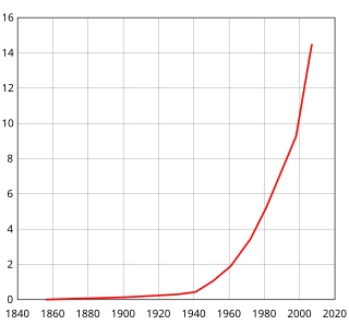
Karachi is the largest and most populous city in Pakistan. The population of Karachi is estimated to be around 16 million (16,093,786) in 2020. The population and demographic distribution in the megacity has undergone numerous changes over the past 150 years. On 14 August 1947, when it became the capital city of Pakistan, its population was about 450,000 inhabitants However, the population rapidly grew with large influx of Muslim refugees after independence in 1947. By 1951, the city population had crossed one million mark. in the following decade, the rate of growth of Karachi was over 80 percent. Today, the city has grown 60 times its size in 1947 when it became the country's first capital. Although, Islamabad remains the nation's capital since the 1960s, the city's population continues to grow at about 5% per annum, largely thanks to its strong economic base.

Kharadar is a neighbourhood in District South of Karachi, Pakistan. Kharadar and the adjacent communities of Mithadar and Jodia Bazaar together form what is regarded as the original core of Karachi.

The demographic history of Karachi of Sindh, Pakistan. The city of Karachi grew from a small fishing village to a megacity in the last 175 years.