
Caernarfon Bay is an inlet of the Irish Sea defined by the Llŷn peninsula and Anglesey.

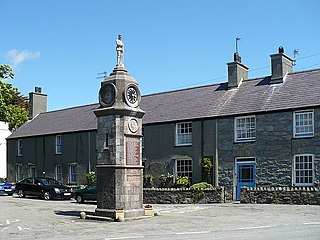
Llangoed is a small village, community and electoral ward just north of Beaumaris, on the Isle of Anglesey, at grid reference SH609793. The Royal Mail postcode begins LL58. Llangoed ward has a population of 1,275 (2001), falling at the 2011 census to 1,229.
The Rothsay Castle was a paddle steamer built in 1816 for service on the River Clyde, Scotland, and was later transferred to Liverpool, England, where she was used for day trips along the coast of North Wales. She was shipwrecked on the Lavan Sands at the eastern end of the Menai Strait, North Wales, in 1831, with the loss of 130 lives.

Puffin Island is an uninhabited island off the eastern tip of Anglesey, Wales. It was formerly known as Priestholm in English and Ynys Lannog in Welsh. A hermitage was established here around the 6th century, and there are remains of a 12th-century monastery on the island. The island is also a Special Protection Area for wildlife.
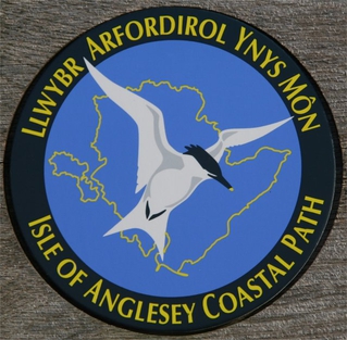
The Anglesey Coastal Path is a 200-kilometre (124 mi) long-distance footpath around the island of Anglesey in North Wales. The route is part of the Wales Coast Path.
Penmon is a promontory, village and ecclesiastical parish on the eastern tip of the Isle of Anglesey in Wales, about 3 miles (4.8 km) east of the town of Beaumaris. It is in the community of Llangoed. The name comes from Welsh: pen and Môn, which is the Welsh word for Anglesey. It is the site of a historic monastery and associated 12th-century church. Walls near the well next to the church may be part of the oldest remaining Christian building in Wales. Penmon also has an award-winning beach and the Anglesey Coastal Path follows its shores. Quarries in Penmon have provided stone for many important buildings and structures, including Birmingham Town Hall and the two bridges that cross the Menai Strait. The area is popular with locals and visitors alike for its monuments, tranquillity, bracing air and fine views of Snowdonia to the south across the Menai Strait.

The mediaeval Welsh cantref of Arfon in north-west Wales was the core of the Kingdom of Gwynedd. Later it was included in the new county of Caernarfonshire, together with Llŷn and Arllechwedd under the terms of the Statute of Rhuddlan in 1284. The island of Anglesey faced it across the Menai Strait; to the east was the cantref of Arllechwedd, to the south the cantref of Eifionydd, and to the west was the cantref of Llŷn.
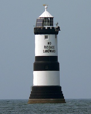
Trwyn Du Lighthouse, also known as Penmon Lighthouse, is a lighthouse between Black Point near Penmon and Ynys Seiriol, or Puffin Island, at the eastern extremity of Anglesey, marking the passage between the two islands.
The Battle of Moel-y-don was a battle fought in 1282 war during the conquest of Wales by Edward I. Also known as the Battle of the Bridge of Boats, it is now considered unlikely the battle site was near Moel-y-don, but farther north.
Dindaethwy was in medieval times one of two commotes of the cantref of Rhosyr, in the south-east of the Isle of Anglesey. It was between the Menai Strait and Conwy Bay, and the Irish Sea and Red Wharf Bay.

Wales, a country that is part of the United Kingdom, contains protected areas under various designations. The largest designation by land area is Wales' three national parks, followed by the five Areas of Outstanding Natural Beauty.
Llanfechell is a village in Anglesey, Wales. It is the largest of several small villages and dispersed settlements that make up Mechell Community Council area. It is 11 miles (18 km) east of Holyhead, and 5.6 miles (9 km) west of Amlwch, in the north of the island.
A clas was a native Christian church in early medieval Wales. Unlike later Norman monasteries, which were made up of a main religious building supported by several smaller buildings, such as cloisters and kitchens, a clas was normally a single building. The building was run by a community of clergy and headed by an abod. Clasau were autonomous and were administered locally.

Arfordir Gogleddol Penmon is a site of special scientific interest (SSSI) on the island of Anglesey, Wales, comprising about 103Ha of land along some 7 km of coastline at the south-east tip of the island.

Rhosybol is a village and community in Anglesey, Wales. The community population at the 2011 census was 1,078. Located 2.5 miles (4.0 km) south of the town of Amlwch, the village is close to both Llyn Alaw, the largest body of water on the island, and Parys Mountain, the site of the historic copper mines which lies just to the north. It is to the mines that the village owes its existence as it was one of several built to house the miners. During the 1960s noted painter Kyffin Williams produced an oil painting of the village.

The Menai Strait fish weirs are historically important fishing traps used in the fast-flowing tidal waters of the Menai Strait, which separates Anglesey from the rest of North Wales. The strait was particularly well suited to utilising fish weirs. The tidal waters pull huge volumes of water past the coastline with every tide, and the weirs and traps enabled fish to be concentrated into small holding areas from which they can be readily caught. Such methods are thought to have been used from earliest times, but the submerged and standing remains along both the Anglesey and Gwynedd coasts are from medieval and post-medieval periods, and in some cases were still in use into the 20th century.
Mechell is a community in the north of the Isle of Anglesey, Wales. Llanfechell is the largest village within the community area. Tregele, Llanfflewyn, Mynydd Mechell, Bodewryd, Rhosbeirio and Carreglefn have a more dispersed settlement pattern. The antiquity of these settlements is shown by the presence of 6 medieval churches and some 16 more ancient sites dating back into prehistory.

Lavan Sands is an intertidal sandbank found in the Menai Strait between Bangor, Gwynedd and Llanfairfechan, Wales. Totally underwater at high tide, at extreme low tides it measures 5.5-mile (8.9 km) east-west and 3.25-mile (5.23 km) north-south. At the western end is found another sandbank Bangor Flats and just north is the sandbank Dutchman's Bank. At low tide the Lavan Sands make the narrowest part of the Menai Straits, at Beaumaris, a mere 237 m (778 ft). The area is designated as an SSSI due in part to the large numbers of Eurasian oystercatchers that migrate there due to the freshwater streams that flow across it.
