Fenny Bentley

Last updated

Fenny Bentley
Fenny Bentley OHall.jpg
Cherry Orchard Farm was once the family home of the Beresfords and known as Bentley Hall. The tower is 15th century.
Derbyshire UK location map.svg
Red pog.svg
Fenny Bentley
Location within Derbyshire
Population305 (2009) [1]
OS grid reference SK178501
  London 145 miles.
Civil parish
  • Fenny Bentley
District
Shire county
Region
Country England
Sovereign state United Kingdom
Post town Ashbourne
Postcode district DE6
Dialling code 01335
Police Derbyshire
Fire Derbyshire
Ambulance East Midlands
UK Parliament
List of places
UK
England
Derbyshire
53°02′52″N1°44′05″W / 53.04783°N 1.73465°W / 53.04783; -1.73465

Fenny Bentley is a small village and civil parish located close to Dovedale in the Derbyshire Dales district of Derbyshire, England. The population in 2009 was 305 reducing to 183 at the 2011 Census. [2] It lies two miles north of Ashbourne, on the A515 Buxton to Ashbourne Road. [3] It is one of the most southerly villages in the Peak District. [4]

Contents

History

Population change in Fenny Bentley Population change in Fenny Bentley.png
Population change in Fenny Bentley

Records show that a settlement has existed at Fenny Bentley since being mentioned in The Domesday Book in 1086, when it was known as Benedlege. Early records of The Church of St. Edmund date back as far as 1240, with much of the available historical data that provides information on the village being associated with the church and the information recorded here. The introduction of the census in the United Kingdom in 1801 means that more consistent information on the parish and how it has developed over time is now available. The population of the village has fluctuated slightly since the 19th century, with a peak in 1841 of 343 people living there. [5] [ failed verification ]

St Edmund's Church

Located in the centre of the village, St Edmunds is an Anglican church that has been heavily restored since being built. Early records of The Church of St. Edmund date back as far as 1240, which show that Fenny Bentley was one of six chapelries attached to St Oswald's Church, Ashbourne [6] The north aisle was added in 1850, and in 1864, the spire was added to the original tower. It has seating for around 200 people. Some interesting features of the building are its 16th-century traceried screens as well as the alabaster Beresford tomb located there, which holds the bodies of Sir Thomas Beresford, his wife Agnes and their 21 children, all shrouded. [5]

Beresford family name

Sir Thomas Beresford, who died in 1473, is buried with his family in St Edmunds Church in the village. They were from a prolific family who lived in the area for generations, and owned much of the property and land there. It is suggested that everyone with the surname Beresford is descended from them and there are still reunions held in Fenny Bentley every spring as it is now the meeting place for the Beresford Family Society. [5]

Cherry Orchard Farm

Cherry Orchard farm is located opposite St Edmunds Church. Previously known as Bentley Hall, it was once the home of the Beresford Family and at the end of the 14th and beginning of the 15th century it was the home of Thomas Beresford as well as his wife and children.

Tattersall Cotton Mill

Many of the residents of Fenny Bentley in the past worked at Tattersell Cotton Mill, which was located in Woodeaves, a nearby hamlet approximately 1 mile from Fenny Bentley. The mill was built in 1784 by John Cooper, and was originally powered by the Bentley Brook. Around 100 people were employed there, mainly for the Nottingham lace and cotton trade. In 1886, the mill was brought by Manchester cotton merchant Cornelius Tattersell, father of John Lincoln Tattersall who was also employed there; he established a home in nearby village Thorpe, Derbyshire with his wife Lizzie Harland in 1893. In 1908, the mill ceased production but the warehouse was taken over in 1910 by William Nuttall. Originally from Melton Mowbray, he was the brother of John Nuttall, who was the owner of the Harlington Cheese Factory. Stilton cheese was produced there until 1930. [7]

On the outskirts of the village is the Leatherbritches Bentley Brook Inn and Fenny's Restaurant, a traditional busy country Inn with its own brewery. The brew house is established in the old washhouse and coal store at the back of the Inn where real ales are brewed two or three times each week.

Geography

Fenny Bentley lies on the southern edge of the Peak District, within the Derbyshire Dales, East Midlands. It lies approximately 3 miles from Dovedale, a Dale that features riverside paths accessible for walkers. Dovedale is centred on the River Dove in a Limestone valley. [8] The site is owned by the National Trust, and the area is very popular with tourists, with the Peak District claiming to be the second most visited National Park in the world with 22 million visitors per year, behind Mount Fuji National Park in Japan. [9] Tourism plays an important role for the few businesses that have been established in Fenny Bentley, such as the Coach and Horses inn which lies on the main route through the village, appealing to visitors to the area who may pass through on the A515 Buxton to Ashbourne Road.

Much of the agricultural land around Fenny Bentley is pasture, the growing of crops being rare. It is suggested that arable farming was never widely practised in the area although this has suggestion has been challenged, with fossilised traces of ridge and furrow being discovered beneath grass covered meadows, in fields around Fenny Bentley, Thorpe and Tissington.

The Peak District Boundary Walk runs through the village. [10]

Demography

Early census reports show that many of the people living in Fenny Bentley in the past worked locally. The majority of males worked in agricultural professions in the area, whilst the majority of females were distributed between having no known profession or being employed in the textiles industry, most likely to be the Tattersall Cotton Mill and other similar locations within the region.

More recently, the population of Fenny Bentley is seen as generally a little older, with a mix of families with older children and retired households. The income in this area is generally above average and residents typically work in managerial positions, are well educated and are likely to have paid off their mortgages. The average house price in the area has decreased more recently, with the average price for a detached house in 2010 being £344,290, compared to an average in the first quarter of 2012 of just £267,833. [11]

Transport

Fenny Bentley has very few transport connections, although being within easy reach of cities such as Derby and Sheffield by road, this is the only transport access to the village. The nearest alternative transport connections are slightly further afield, Matlock Bath railway station is located 8.98 miles away, whilst East Midlands Airport is 22.98 miles from the village. The nearest port is located in Liverpool, approximately 57 miles from Fenny Bentley. [12]

See also

Related Research Articles

<span class="mw-page-title-main">Ashbourne, Derbyshire</span> Market town in Derbyshire, England

Ashbourne is a market town in the Derbyshire Dales district in Derbyshire, England. Its population was measured at 8,377 in the 2011 census and was estimated to have grown to 9,163 by 2019. It has many historical buildings and independent shops. The town offers a historic annual Shrovetide football match. Its position near the southern edge of the Peak District makes it the closest town to Dovedale, to which Ashbourne is sometimes referred to as the gateway.

<span class="mw-page-title-main">Hartington, Derbyshire</span> Human settlement in England

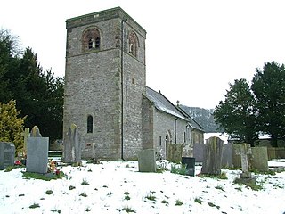
Hartington is a village in the centre of the White Peak area of the Derbyshire Peak District, England, lying on the River Dove which is the Staffordshire border. According to the 2001 census, the parish of Hartington Town Quarter, which also includes Pilsbury, had a population of 345 reducing to 332 at the 2011 Census. Formerly known for cheese-making and the mining of ironstone, limestone and lead, the village is now popular with tourists.

<span class="mw-page-title-main">River Dove, central England</span> River in Derbyshire and Staffordshire, England

The River Dove is the principal river of the southwestern Peak District, in the Midlands of England, and is around 45 miles (72 km) in length. It rises on Axe Edge Moor near Buxton and flows generally south to its confluence with the River Trent at Newton Solney. From there, its waters reach the North Sea via the Humber Estuary. For almost its entire course it forms the boundary between the counties of Staffordshire and Derbyshire. The river meanders past Longnor and Hartington and cuts through a set of deep limestone gorges, Beresford Dale, Wolfscote Dale, Milldale and Dovedale.

<span class="mw-page-title-main">Dovedale</span> Valley in the Peak District, England

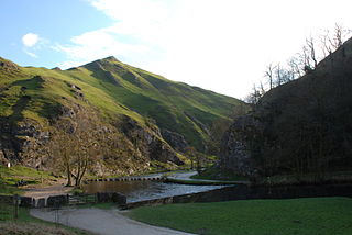
Dovedale is a valley in the Peak District of England. The land is owned by the National Trust and attracts a million visitors annually. The valley was cut by the River Dove and runs for just over 3 miles (5 km) between Milldale in the north and a wooded ravine, near Thorpe Cloud and Bunster Hill, in the south. In the wooded ravine, a set of stepping stones cross the river and there are two caves known as the Dove Holes.

<span class="mw-page-title-main">Tissington Trail</span> Bridleway in the English Peak District

The Tissington Trail is a bridleway, footpath and cycleway in Derbyshire, England, along part of the trackbed of the former railway line connecting Ashbourne to Buxton. It takes its name from the village of Tissington, which it skirts. Opened in 1971, and now a part of the National Cycle Network, it stretches for 13 miles (21 km) from Parsley Hay (53.1706°N 1.7828°W) in the north to Ashbourne (53.0196°N 1.7397°W) in the south.

<span class="mw-page-title-main">Alsop en le Dale</span> Human settlement in England

Alsop en le Dale is a village in Derbyshire, England about 5 miles (8.0 km) north of Ashbourne close to the Staffordshire border, and a mile from Dovedale, a popular tourist location within the Peak District national park. It is within the civil parish of Eaton and Alsop.

The Ashbourne line was a 33+12 mi (53.9 km) railway from Buxton via Ashbourne to Uttoxeter. It was built by the London and North Western Railway using a section of the Cromford and High Peak Railway (C&HPR) and it joined the North Staffordshire Railway at Ashbourne, proceeding to Uttoxeter with a junction onto the main line at Rocester.

Thorpe Cloud railway station was opened in 1899 between the villages of Thorpe and Fenny Bentley in Derbyshire, south east of Buxton.

<span class="mw-page-title-main">Wetton, Staffordshire</span> Human settlement in England

Wetton is a village in the Peak District National Park, North Staffordshire, at the top of the east side of the Manifold Valley. The population recorded in the 2001 Census was 157. At the time of the 2011 Census the population was recorded under Ilam. This article describes the location, some of the main features of the village, and a number of places of historical or general interest in or near the village. These include Long Low, Wetton, a prehistoric burial site unique to England.

<span class="mw-page-title-main">Dovedale cheese</span> British blue cheese from the Peak District

Dovedale, sold as Dovedale Blue, is a blue cheese. It is named after the Dovedale valley in the Peak District, near where it is produced.

John Lincoln Tattersall was an English cotton merchant and Liberal Party politician.

<span class="mw-page-title-main">A515 road</span> Road in England

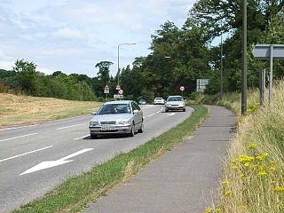
The A515 is a primary route in England, which runs from Lichfield in Staffordshire to Buxton in Derbyshire.

<i>Dovedale by Moonlight</i> Painting by Joseph Wright of Derby

Dovedale by Moonlight, 1784, is one of five paintings by Joseph Wright of Derby which uses the picturesque valley of Dovedale as its subject. These paintings were sometimes made as pairs with one showing the view by day and the other by moonlight. Wright admitted that he had not observed this scene directly, "Moon lights & fire lights are but a sort of work with me for I cant with impunity go out at night and study the former, & the latter I have seen but once, and at a time too, when I thought not of painting such effects."

<span class="mw-page-title-main">Bentley Brook, Bradbourne</span> River in England

The Bentley Brook or Bradbourne Brook is a small tributary of the River Dove in Derbyshire, England, and is 14.5 kilometres long

The Hundreds of Derbyshire were the geographic divisions of the historic county of Derbyshire for administrative, military and judicial purposes. They were established in Derbyshire some time before the Norman conquest. In the Domesday Survey of 1086 AD the hundreds were called wapentakes. By 1273 the county was divided into 8 hundreds with some later combined, becoming 6 hundreds over the following centuries. The Local Government Act 1894 replaced hundreds with districts. Derbyshire is now divided into 8 administrative boroughs within the Derbyshire County Council area.

<span class="mw-page-title-main">Hartington Middle Quarter</span> Civil parish in Derbyshire, England

Hartington Middle Quarter is a civil parish within the Derbyshire Dales district, which is in the county of Derbyshire, England. Formerly a part of Hartington parish, for which it is named, it has a mix of a number of villages and hamlets amongst a mainly rural and undulating landscape, and is wholly within the Peak District National Park. It had a population of 379 residents in 2011. The parish is 130 miles (210 km) north west of London, 20 miles (32 km) north west of the county city of Derby, and 5 miles (8.0 km) south east of the nearest market town of Buxton. Being on the edge of the county border, it shares a boundary with the parishes of Chelmorton, Flagg, Hartington Town Quarter, Hartington Upper Quarter, Middleton and Smerrill, Monyash in Derbyshire, as well as Hollinsclough, Longnor and Sheen in Staffordshire.

<span class="mw-page-title-main">Offcote and Underwood</span> Civil parish in Derbyshire, England

Offcote and Underwood is a civil parish within the Derbyshire Dales district, in the county of Derbyshire, England. Largely rural, in 2011 the parish had a population of 526. It is 125 miles (201 km) north west of London, 13 miles (21 km) north west of the county city of Derby, and 1 mile north east of the market town of Ashbourne. Offcote and Underwood borders the Peak District, and touches the parishes of Ashbourne, Bradley, Clifton and Compton, Fenny Bentley, Kniveton, Mapleton and Okeover. There are 12 listed buildings in Offcote and Underwood.

<span class="mw-page-title-main">Eaton and Alsop</span> Civil parish in England

Eaton and Alsop is a civil parish within the Derbyshire Dales district, in the county of Derbyshire, England. Largely rural, in 2021 Eaton and Alsop had a population of only 80 residents. It is 130 miles (210 km) north west of London, 17 miles (27 km) north west of the county city of Derby, and 6 miles (9.7 km) north of the market town of Ashbourne. Eaton and Alsop is wholly within the Peak District national park, and touches the parishes of Alstonefield, Hartington Nether Quarter, Newton Grange and Parwich. There are five listed buildings in Eaton and Alsop.

<span class="mw-page-title-main">Tissington and Lea Hall</span> Civil parish in Derbyshire, England

Tissington and Lea Hall is a civil parish within the Derbyshire Dales district, which is in the county of Derbyshire, England. Named for its settlements and sparsely built up with much rural expanse, its population was 134 residents in the 2021 census. The parish is 125 miles (201 km) north west of London, 15 miles (24 km) north west of the county town of Derby, and 3 miles (4.8 km) north of the nearest market town of Ashbourne. It shares a boundary with the parishes of Ballidon, Bradbourne, Fenny Bentley, Kniveton, Newton Grange, Parwich and Thorpe. The parish is wholly within the Peak District National Park.

References

  1. "Visionofbritain.org.uk (2001) Vision of Britain. Credits and Copyright" . Retrieved 3 April 2012..
  2. "Civil Parish population 2011". Neighbourhood Statistics. Office for National Statistics. Archived from the original on 20 September 2016. Retrieved 24 March 2016.
  3. "Landslide on the B5056 Fenny Bentley". Bgs.ac.uk (2010). British Geological Survey (BGS). Retrieved 20 April 2012.
  4. "Rogerandsally.co.uk (2009) A brief history of Fenny Bentley". Archived from the original on 20 May 2012. Retrieved 3 April 2012.
  5. 1 2 3 "Fenny Bentley". Derbyshire UK: Guide to Derbyshire & the Peak District. Retrieved 23 June 2023.
  6. Derbyshireheritage.co.uk (2012). St Edmund's Church at Fenny Bentley. [online] Available at: http://www.derbyshireheritage.co.uk/Menu/Buildings/Churches/St-Edmunds.php [Accessed: 22 April 2012].].
  7. Hartingtoncheeseshop.co.uk The Hartington Cheese and Wine Company – a history of Hartington and Stilton Cheese. [online] Available at: http://www.hartingtoncheeseshop.co.uk/hartington_cheeseshop.asp Archived 22 February 2012 at the Wayback Machine [Accessed: 31 April 2012].
  8. Peakdistrict.nationaltrust.org.uk (2011) Dovedale | Peak District | The National Trust. [online] Available at: http://www.peakdistrict.nationaltrust.org.uk/dovedale [Accessed: 30 April 2012].
  9. Roachestearooms.co.uk (n.d.) The Peak District National Park, Tea Rooms, Holiday Cottage. [online] Available at: http://www.roachestearooms.co.uk/the_peak_district.html [Accessed: 1 May 2012].
  10. McCloy, Andrew (2017). Peak District Boundary Walk: 190 Miles Around the Edge of the National Park. Friends of the Peak District. ISBN   978-1909461536.
  11. Upmystreet.com (2009) 2012 Property Price in DE6 1LB. [online] Available at: http://www.upmystreet.com/properties/house-prices/de6-1lb.html [Accessed: 30 April 2012].
  12. Localities [ permanent dead link ],