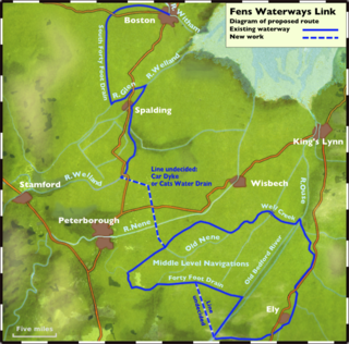
Fens Waterways Link

Last updated

Boston to Peterborough Wetland Corridor
River Glen near the confluence with the River Welland (Geograph 435558).jpg
The new Fens Waterways Link route to Spalding is from the River Glen (foreground) right into the River Welland (middle distance)
Specifications
StatusPartially constructed
Navigation authority Environment Agency
History
Former namesFens Waterways Link
Geography
Start point Boston
End point Peterborough
Connects to River Witham, River Glen, River Welland, River Nene
Boston to Peterborough
Wetland Corridor
BSicon uCONTg.svg
River Witham
BSicon uSTOPLOCK.svg
Grand Sluice
BSicon uSTR+FEATURE@l.svg
Boston
BSicon uSTR+l.svg
BSicon uHSTOPLOCK.svg
BSicon uFABZgr+r.svg
South Forty-Foot Drain
BSicon uSTR.svg
BSicon uENDE.svg
Boston Barrage
BSicon uSTR.svg
BSicon uSTRl.svg
BSicon uCONTfq.svg
The Haven
BSicon uSTR.svg
BSicon uSKRZ-Au.svg
A52 Donington High Bridge
BSicon uexSTR.svg
Start of Phase 3
BSicon uexSTR.svg
BSicon uLSTRl.svg
BSicon uLSTR+r.svg
Fens Link (Route 11)
BSicon uexSTR.svg
BSicon uLLock5.svg
New lock (Route 11)
BSicon uxSLUICEbl.svg
BSicon uLSTR.svg
Black Hole Drove PS
BSicon uexSKRZ-Au.svg
BSicon uLSKRZ-Au.svg
A151 Bourne Road bridge
BSicon uexSTR.svg
BSicon uLLock5.svg
New lock (Route 11)
BSicon uexCONTgq.svg
BSicon uLSTR.svg
BSicon uexSTRr.svg
BSicon uLSTR.svg
Fens Link (Route 1 and 11)
BSicon uexCONTgq.svg
BSicon uSTRq.svg
BSicon uLSTRl.svg
BSicon uSTRq.svg
BSicon uLSTRl.svg
BSicon uSTR+r.svg
River Glen
BSicon uSTR.svg
BSicon uLSTR+l.svg
BSicon uLSTRr.svg
BSicon uSTR.svg
new route via Vernatt's Drain
BSicon uLSTR.svg
BSicon uSLUICEbl.svg
Surfleet Seas End sluice
BSicon uLSTR.svg
BSicon uABZl+l.svg
BSicon uCONTfq.svg
River Welland
BSicon uLSTR.svg
BSicon uSLUICEbl.svg
Possible new sluice on R Welland
BSicon uLSTRl.svg
BSicon uLSTR+r.svg
BSicon uSTR.svg
BSicon uSTOPLOCK.svg
Fulney Lock
BSicon uSTR.svg
River Welland
BSicon uSTR.svg
BSicon uSTR+FEATURE@l.svg
Crowland
BSicon uexCONTgq.svg
BSicon uFABZq+lr.svg
BSicon uLSTR.svg
BSicon uSTRr.svg
BSicon POINTERg@fq.svg
BSicon uLSTR.svg
BSicon uLSTR.svg
Folly Drain and Car Dyke route
BSicon uLSTR.svg
BSicon POINTERg@fq.svg
BSicon uLSTR.svg
Cat's Water Drain route
BSicon uLSTR+l.svg
BSicon uLSTRq.svg
BSicon uLSTR.svg
BSicon uLSTRr.svg
Welland to Nene Link
BSicon uLSTR.svg
BSicon uLSTR.svg
BSicon uLSTR.svg
BSicon uSTR+l.svg
BSicon uSTRq.svg
BSicon uLABZqlr.svg
BSicon uFABZq+lr.svg
BSicon uCONTfq.svg
River Nene
BSicon uSTR+FEATURE@r.svg
BSicon uLock5.svg
Peterborough
BSicon uCONTgq.svg
BSicon uSTRr.svg
BSicon uLock5.svg
Stanground and Ashline Locks
BSicon uSTR.svg
BSicon uSTR+l.svg
BSicon uFABZqlr.svg
BSicon uSTR+r.svg
River Nene old course
BSicon uCONTgq.svg
BSicon uFABZq+lr.svg
BSicon uSTRq.svg
BSicon uSTRr.svg
BSicon uSTR.svg
Middle Level Navigations
BSicon uSTR.svg
BSicon uSTOPLOCK.svg
Salters Lode Lock
BSicon uSTR.svg
BSicon uSTR+l.svg
BSicon uSTRq.svg
BSicon uFABZqlr.svg
BSicon uCONTfq.svg
River Great Ouse
BSicon uSTR.svg
BSicon uABZg2.svg
BSicon uSTRc3.svg
BSicon uSTR.svg
BSicon uSTRc1.svg
BSicon uSTOPLOCK.svg
BSicon uABZ4+2f.svg
BSicon uSTRc3.svg
Old Bedford River sluice
BSicon uSTR.svg
BSicon uSTR.svg
BSicon uSTR+c1.svg
BSicon uSTR+4.svg
New Bedford River
BSicon uSTR.svg
BSicon uSTR.svg
BSicon uSTR.svg
BSicon uSTOPLOCK.svg
Denver Sluice
BSicon uLSTR+l.svg
BSicon uLSTRr.svg
BSicon uSTR.svg
BSicon uSTR.svg
BSicon uSTR.svg
BSicon uSTR.svg
New route through Chatteris
BSicon uLSTR.svg
BSicon uLSTR.svg
BSicon uSTRl.svg
BSicon uHSTOPLOCK.svg
BSicon uFABZgr+r.svg
BSicon uSTR.svg
BSicon uSTR.svg
Welches Dam (rebuild lock)
BSicon uLSTR.svg
BSicon uLSTRl.svg
BSicon uLHSTOPLOCK.svg
BSicon uLKRZqo.svg
BSicon uLSTR+r.svg
BSicon uSTR.svg
BSicon uSTR.svg
New lock and aqueduct
BSicon uLSTR.svg
BSicon uexSTRc2.svg
BSicon uexSTRc2.svg
BSicon uexSTR3.svg
BSicon uSTR3.svg
BSicon uSTR.svg
BSicon uLSTR.svg
BSicon uexSTR+1.svg
BSicon uexSTRc4.svg
BSicon uSTR+1.svg
BSicon uSTRc4.svg
BSicon uSTR.svg
BSicon uLSTRl.svg
BSicon uLSTRq.svg
BSicon uLSTR+r.svg
BSicon uexSTR.svg
BSicon uSTR.svg
BSicon uSTR.svg
BSicon uLSTR+l.svg
BSicon uLSTRr.svg
BSicon uexSTR.svg
BSicon uSTR.svg
BSicon uSTR.svg
BSicon uLSTOPLOCK.svg
BSicon uxWEIRf.svg
BSicon uSTR.svg
BSicon uSTR.svg
Earith Sluice and new bypass
BSicon uLSTRl.svg
BSicon uLSTR+r.svg
BSicon uxABZg+l.svg
BSicon uFABZqlr.svg
BSicon uHSTOPLOCK.svg
BSicon uSTRr.svg
Hermitage Sluice
BSicon uCONTf.svg
River Great Ouse

The Fens Waterways Link is a project to improve recreational boating opportunities in the counties of Cambridgeshire and Lincolnshire, England. [1] By a combination of improvements to existing waterways and the construction of new links a circular route between Lincoln, Peterborough, Ely and Boston is planned. The project is being organised by the Environment Agency and financed from the Regional Development Agency and the European Union.

Contents

A separate, complementary waterway is the Bedford and Milton Keynes Waterway, opening up a route for broader beam boats between The Fens and the rest of Britain's canal network.

History

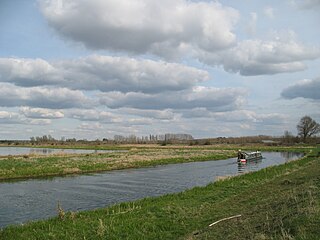
The idea of creating a navigable waterway between Boston and Peterborough was promoted in 2005. It was described by the Environment Agency as the biggest project for the enhancement of waterways in Europe at the time, and would make 150 miles (240 km) of waterways accessible to inland boats, without them having to venture into the Wash. Lincolnshire has a greater length of rivers than the Norfolk Broads, but whereas the Broads are hugely popular with boaters, Lincolnshire's rivers were much less so. [1]

Initially, the main focus was on navigation, and to move the ideas forwards, Lincolnshire County Council, the Environment Agency and British Waterways formed the Lincolnshire Waterways Partnership. This acted as an umbrella organisation, with each of the partners working on projects to achieve the aim of a better connected waterways infrastructure. Schemes with a total value exceeding £20 million were implemented, [2] the first of which was the reconnection of the South Forty-Foot Drain to The Haven by the construction of a new lock beside the Black Sluice pumping station. [3] The schemes enabled new businesses to thrive, and resulted in significant private sector investment in related projects. [2]

Lincolnshire County Council's involvement was outlined in a ten-year plan entitled Lincolnshire Waterways for the Future, covering the period from 2008 to 2018. As that period came to an end, they produced a Waterways Development Strategy, covering 2018 to 2028. The objectives were slightly different. While they were still trying to make the waterways more viable economically, the new strategy had a wider remit, and seeks to work with others who are also working on water-related projects. One possible collaboration is with Anglian Water, who are looking for solutions to providing an adequate public water supply as the population grows. This might include water transfers between the Trent, the Witham and the South Forty-Foot Drain to one or more new reservoirs. If these transfers use open channels, rather than pipelines, they could create waterways corridors, which would provide both habitat and navigation. [4] By working together, such projects can address issues of the environment, flood mitigation and water security, with the costs shared so that one project meets the objectives of several organisations. The Fens Waterways Link has been rebranded as the Boston to Peterborough Wetland Corridor to reflect this change of emphasis, but navigation will still be part of the aim. The Inland Waterways Association will lead future development, working with Lincolnshire County Council and the Environment Agency. [5]

By 2018, the scheme had been divided into six phases. Phases 1 and 2 covered the reconnection of the South Forty-Foot Drain to the Haven, and upgrading of the South Forty-Foot Drain as far a Donington High Bridge, These were completed in 2009. Phase 3 covers the 17-mile (27 km) link from Donington High Bridge to Surfleet Seas End sluice. This includes a new channel between the South Forty-Foot Drain and the River Glen. Surfleet Seas End sluice is close to where the River Glen joins the River Welland. Phase 4 is 14 miles (23 km) long, and covers the section between Surfleet and Crowland on the River Welland. Crowland is towards the upper end of the navigable Welland. Phase 5 is a new 9-mile (14 km) link between the Welland at Crowland and the River Nene near Peterborough. The Middle Level Navigations also join the Nene near Peterborough, and Phase 6 covers modifications to link them to the Old Bedford River or the New Bedford River and therefore into the River Great Ouse system. Lincolnshire's plan is not clear on how this could work, as it is outside of their administrative area, but their map shows either the re-establishment of the link through the closed Welches Dam lock, or a new channel to join the Great Ouse at Earith. [6] They believe that the Boston to Peterborough corridor can be delivered in the short to medium term, whereas the route beyond Peterborough is more problematic. [7]

Northern route

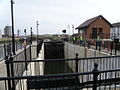
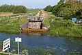
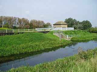
Starting from the north, the first development was the provision of a new tidal lock from the Haven in Boston to the South Forty-Foot Drain at the Black Sluice, opened to traffic on 20 March 2009 by Michaela Strachan. The cost of the project was £8.5 million, of which £4 million came from Lincolnshire County Council, £2.5 million from the European Regional Development Fund and £2 million from the East Midlands Regional Development Agency. [8] At the time, phase two of the project involved widening of the South Forty-Foot Drain from Donington to a new road crossing under the A151 road, a new lock and a junction with the River Glen, a tributary of the River Welland, at Guthram Gowt. It was easier to get funding for the actual project, but more difficult to get funding to cover the preparatory work, but this problem was recognised by the East Midlands Development Agency, who funded the early stages up to and including obtaining planning permission. [9]

The Lincolnshire Waterways Partnership originally thought that the preparatory work could be completed by March 2010. However, as the route options, the engineering challenges, the environmental considerations and the costs were considered, the scope of the project grew. It became clear that the March 2010 deadline would not be met, and so only part of the East Midlands Development Agency funding was used before their deadline ran out. The Environment Agency then began to look at whether the project could be delivered in conjunction with a flood risk management scheme for the South Forty-Foot Drain. [10] By late 2011, eight possible routes were being considered for the link into the River Glen. The adoption of the Water Framework Directive also meant that the project needed to ensure that water quality improved, and a £150,000 grant was received, to consider how the link might create improved habitat and better water supplies. [11] Eventually, eleven routes were considered, of which two were shortlisted. Route 1 was the original route, with a lock to get round Black Hole Drove pumping station, continuing along a widened South Forty-Foot Drain to Guthram Gowt, and then a lock into the River Glen. Route 11 also had a lock near the pumping station, but then used a new channel to reach the A151 road and a lock into the Glen. Route 1 was then discarded when a landowner changed their support for that route. [12]

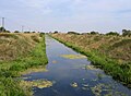
Navigation between the Glen and the Welland is currently possible, but involves passing through Surfleet sluices, which can only be done at certain limited states of the tide, making a sharp turn on a tidal river where the two rivers converge, and passage through Fulney Lock on the Welland to reach Spalding. The lock is tidal and in need of refurbishment or replacement. One possibility is the construction of a new lock and sluice structure at Surfleet, and improving Fulney Lock. A second solution is the construction of a new sluice on the Welland, 2.8 miles (4.5 km) below Fulney Lock. This would allow Fulney lock to be decommissioned, with a short new channel constructed from the Welland into Vernatt's Drain, and a second short link from Vernatt's Drain into the Glen above Surfleet Sluices. Vernatt's Drain is currently owned by the Welland and Deepings Internal Drainage Board, and so negotiation would be required to use this route. However, it is the preferred choice, as it would also reduce the amount of flood defence work required on the Welland in this locality. [13]

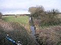
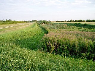
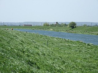
In order to reach Peterborough, a new cut will be required between the Welland and the River Nene downstream of the city, near Flag Fen. Two routes are under consideration. The first would start near Peakirk pumping station, where the Folly River joins the Welland. A lock would be required to bypass the pumping station, as the water levels of the two waterways are not the same. [14] After about 1.9 miles (3 km) the Folly River joins the Car Dyke, which follows the north-eastern edge of Peterborough to the village of Eye. [15] [16] An alternative route would leave the Welland at Postland pumping station, further downstream and nearer to Crowland, and follow the course of Kennulph's Drain to Kennulph Farm. From there a new section of canal would carry the route around the hamlet of Nene Terrace and link into Cat's Water Drain, which also passes close to Eye. [17] The final part of the link would either be a new canal or would follow the remainder of Cat's Water Drain and a drainage ditch to reach Padholme pumping station. [18] While the Folly River and Car Dyke look to be more suitable for navigation, some dredging and widening of Car Dyke would be required, and as much of this section is a scheduled monument it is thought that English Heritage would not want any work to take place on it. The preferred route therefore follows the much smaller Cat's Water Drain. [19]

Southern route

Access to the Middle Level Navigations is along King's Dyke, which leaves the Nene a short distance downstream of where the northern route would end. Kings Dyke passes through Stanground Lock and Ashline Lock, after which Whittlesey Dyke can be used to access the old course of the River Nene at Floods Ferry. Initial plans for the Fens Waterways Link included creating a circular cruising route to the south, which would include parts of the Middle Level Navigations and of the River Great Ouse. For this to work well, some work would be required on King's Dyke, as water levels are sometimes too low for navigation. [20] The recommended route for boats crossing the Middle Level from the Nene to the Great Ouse follows the old course of the Nene to Upwell and Outwell, and then continues along Well Creek to Salters Lode Lock. [21] To reach the Great Ouse, boats must use Salters Lode Lock to enter the tidal section of the Great Ouse, and then use Denver Sluice to reach the non-tidal section. This transition is not easy, due to tidal levels, frequent silation below the sluice making access difficult, and the poor state of Salters Lode Lock. In order to mitigate this, one proposal was to create a short new section of canal from Well Creek and ascend through a couple of locks, to cross over the New Bedford River on an aqueduct. More locks would then drop the level so that boats could join the Great Ouse above Denver Sluice. This would avoid the need to refurbish Salters Lode Lock, and would not require boaters to negotiate the tidal river. [22]

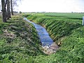
The Great Ouse from Denver Sluice up to Ely is not thought to need any attention, as it is wide and deep and there are no navigation structures on that length. [23] The next section from the Fish and Duck Inn near Stretham to Hermitage Lock at Earith needs more attention, as it has suffered from a lack of funding, due to its catchment being very small. The channel is narrow in places, the banks suffer from erosion, and water levels are at times quite shallow. This would be addressed by a programme of dredging. [24] To complete a circular route would require some way to get from Earith back to the old course of the Nene. Currently, the Forty Foot Drain, which is also known as Vermuyden's Drain, runs from Welches Dam and Horseway Lock through Chatteris to join the old course of the Nene near Ramsey. [25] The channel between Welches Dam and Horseway Lock was always shallow, and access was restricted to certain weekends, but in 2006 the Environment Agency closed the lock at Welches Dam, and the channel has since become overgrown with reeds. [26] [27]

Three options were proposed to complete the circular route. One was to build an aqueduct to carry boats from Welches Dam over the Old Bedford River and into the tidal New Bedford River, which joins the Great Ouse above Hermitage Lock. The second was to build a new lock between Welches Dam and the Old Bedford River. The section above Welches Dam to the sluice at Earith would be enlarged so that it became navigable, and a new lock structure would be built to bypass Earith Sluice. The third option involved making the Twenty Foot River navigable towards Chatteris. This then becomes Fenton's Lode, and the new route would follow Fenton's Lode to High Fen pumping station. A new section of canal would run from the pumping station to a drainage ditch called Cranbrook Drain, which would be enlarged and join the Old Bedford River below Earith Sluice. Upgrading of the final section of the Old Bedford River would be required, and again, a lock structure to bypass Earith Sluice would be needed. The second route was the preferred option in 2003, [28] although Lincolnshire County Council still showed all three routes on their 2018 plan. [6]

The completion of the project would be the long-discussed Bedford and Milton Keynes Waterway canal between Bedford and Milton Keynes following the course of the Great Ouse and joining the Grand Union Canal, mooted as the "first new canal in over a century". The funding for this is slowly appearing and as well as providing for the first time an inland route for broader boats—up to 3.2 metres (10 ft 6 in) wide—between the north and south of England, it would also serve as a flood relief channel for new developments in the areas through which it is to pass. This extra benefit might release funding from wider sources. [29] Adaptation of existing locks and bridges would be necessary to increase the dimensions to Grand Union Canal gauge, both in width and air draft.

Precursors

Although using a slightly different route, there are echoes of plans made in 1809 to link the waterways. Two schemes were proposed, one which would have created a canal from Stamford to the Oakham Canal, 11 miles (18 km) due west, with a link from Stamford to the Nene at Peterborough, and a connection from near Market Deeping on the Welland, and a rival scheme to link Stamford to the Grand Junction Canal, both of which included a connection to the South Forty-Foot Drain. Both were put before Parliament in 1811, but neither met with any success. The idea was raised again in 1815 and 1828, but no further action was taken. [30]

See also

Related Research Articles

<span class="mw-page-title-main">River Witham</span> River in eastern England

The River Witham is a river almost entirely in the county of Lincolnshire in the east of England. It rises south of Grantham close to South Witham at SK8818, passes through the centre of Grantham, passes Lincoln at SK9771 and at Boston, TF3244, flows into The Haven, a tidal arm of The Wash, near RSPB Frampton Marsh. The name "Witham" seems to be extremely old and of unknown origin. Archaeological and documentary evidence shows the importance of the Witham as a navigable river from the Iron Age onwards. From Roman times it was navigable to Lincoln, from where the Fossdyke was constructed to link it to the River Trent. The mouth of the river moved in 1014 following severe flooding, and Boston became important as a port.

<span class="mw-page-title-main">River Welland</span> Lowland river in the east of England

The River Welland is a lowland river in the east of England, some 65 miles (105 km) long. It drains part of the Midlands eastwards to The Wash. The river rises in the Hothorpe Hills, at Sibbertoft in Northamptonshire, then flows generally northeast to Market Harborough, Stamford and Spalding, to reach The Wash near Fosdyke. It is a major waterway across the part of the Fens called South Holland, and is one of the Fenland rivers which were laid out with washlands. There are two channels between widely spaced embankments with the intention that flood waters would have space in which to spread while the tide in the estuary prevented free egress. However, after the floods of 1947, new works such as the Coronation Channel were constructed to control flooding in Spalding and the washes are no longer used solely as pasture, but may be used for arable farming.

<span class="mw-page-title-main">River Great Ouse</span> River in England

The River Great Ouse is a river in England, the longest of several British rivers called "Ouse". From Syresham in Northamptonshire, the Great Ouse flows through Buckinghamshire, Bedfordshire, Cambridgeshire and Norfolk to drain into the Wash and the North Sea near Kings Lynn. Authorities disagree both on the river's source and its length with one quoting 160 mi (260 km) and another 143 mi (230 km). Mostly flowing north and east, it is the fifth longest river in the United Kingdom. The Great Ouse has been historically important for commercial navigation, and for draining the low-lying region through which it flows; its best-known tributary is the Cam, which runs through Cambridge. Its lower course passes through drained wetlands and fens and has been extensively modified, or channelised, to relieve flooding and provide a better route for barge traffic. The unmodified river would have changed course regularly after floods.

<span class="mw-page-title-main">River Little Ouse</span> River in east England

The River Little Ouse is a river in the east of England, a tributary of the River Great Ouse. For much of its length it defines the boundary between Norfolk and Suffolk.

<span class="mw-page-title-main">The Fens</span> Natural region on the east coast of England

The Fens, also known as the Fenlands, in eastern England are a naturally marshy region supporting a rich ecology and numerous species. Most of the fens were drained centuries ago, resulting in a flat, dry, low-lying agricultural region supported by a system of drainage channels and man-made rivers and automated pumping stations. There have been unintended consequences to this reclamation, as the land level has continued to sink and the dykes have been built higher to protect it from flooding.

<span class="mw-page-title-main">Old Bedford River</span> Watercourse in Cambridgeshire, England

The Old Bedford River is an artificial, partial diversion of the waters of the River Great Ouse in the Fens of Cambridgeshire, England. It was named after the fourth Earl of Bedford who contracted with the local Commission of Sewers to drain the Great Level of the Fens beginning in 1630. It provided a steeper and shorter path for the waters of the Great Ouse, and was embanked to prevent them flooding the low ground of the South Fens. Throughout the project, the Earl and his Adventurers faced disruption from those who were opposed to drainage schemes. The project was deemed to have succeeded in draining the fens in 1637, but that decision was reversed in 1638. After a lull during the English Civil War, when much of the work was damaged, the Dutch engineer Cornelius Vermuyden worked with William Russell, the fifth Earl of Bedford to complete the drainage. Disruption and unrest continued while the work was carried out, resulting in the Adventurers employing armed guards. A second river, the New Bedford River, was cut parallel to the first channel, which then became the Old Bedford River. At some point, the Old Bedford River was split into two parts, when the upper section was diverted into the River Delph at Welches Dam, and the lower section was joined to the Counter Drain. Both parts retain the name, but are not connected to each other. The area between the two Bedford rivers acts as a large washland, which holds floodwater when the river channels cannot cope with the volume of water in them.

<span class="mw-page-title-main">New Bedford River</span> Watercourse in Cambridgeshire, England

The New Bedford River, also known as the Hundred Foot Drain because of the distance between the tops of the two embankments on either side of the river, is a navigable man-made cut-off or by-pass channel of the River Great Ouse in the Fens of Cambridgeshire, England. It provides an almost straight channel between Earith and Denver Sluices. It is tidal, with reverse tidal flow being clearly visible at Welney, some 19 miles (31 km) from the sea.

<span class="mw-page-title-main">River Glen, Lincolnshire</span> River in Lincolnshire and Rutland, England

The River Glen is a river in Lincolnshire, England with a short stretch passing through Rutland near Essendine.

Sir Cornelius Vermuyden was a Dutch engineer who introduced Dutch land reclamation methods to England. Vermuyden was commissioned by the Crown to drain Hatfield Chase in the Isle of Axholme, Lincolnshire, Vermuyden was knighted in 1629 for his work and became an English citizen in 1633. In the 1650s, he directed major projects to drain The Fens of East Anglia, introducing the innovation of constructing washes, to allow periodic flooding of the area by excess waters.

<span class="mw-page-title-main">South Forty-Foot Drain</span> Drainage canal in eastern England

The South Forty-Foot Drain, also known as the Black Sluice Navigation, is the main channel for the land-drainage of the Black Sluice Level in the Lincolnshire Fens. It lies in eastern England between Guthram Gowt and the Black Sluice pumping station on The Haven, at Boston. The Drain has its origins in the 1630s, when the first scheme to make the Fen land available for agriculture was carried out by the Earl of Lindsey, and has been steadily improved since then. Water drained from the land entered The Haven by gravity at certain states of the tide until 1946, when the Black Sluice pumping station was commissioned.

<span class="mw-page-title-main">Car Dyke</span> Ditch in the Fens in eastern England

The Car Dyke was, and to a large extent still is, an 85-mile (137 km) long ditch which runs along the western edge of the Fens in eastern England. It is generally accepted as being of Roman age and, for many centuries, to have been taken as marking the western edge of the Fens. There, the consensus begins to break down.

<span class="mw-page-title-main">Bourne Eau</span> River in Lincolnshire, England

Bourne Eau is a short river which rises from an artesian spring in the town of Bourne in Lincolnshire, England, and flows in an easterly direction to join the River Glen at Tongue End. Within the town, it once powered three water mills, one of which is now a heritage centre. At Eastgate, it becomes much wider as it was navigable in the 18th and 19th centuries, and this was the location of the terminal basin. Below the town it is an embanked river, as its normal level is higher than that of the surrounding Fens. Navigation ceased in the 1860s and the river now forms an important part of the drainage system that enables the surrounding fen land to be used for agriculture.

Lincolnshire is a large county in England with a sparse population distribution, which leads to problems funding all sorts of transport. The transport history is long and varied, with much of the road network still based on the Roman model, and the once extensive rail network a shadow of its former self.

<span class="mw-page-title-main">Stamford Canal</span> Canal in Lincolnshire, England

Stamford Canal, now disused, is one of the earliest post-Roman canals in England. It opened in 1670, around 100 years before the start of the Industrial Revolution which brought about the "golden age" for canals in Britain. Parts of the route can be traced on the ground, though only one lock survives intact. It was part of the Welland Navigation in Lincolnshire. First authorised in 1571, during the reign of Elizabeth I, construction did not start until 1664, under powers granted in 1620 and ratified by James I. It ran for 9.5 miles (15.3 km) from Stamford to Market Deeping and had 12 locks, two of which were on the river section at Deeping St James. No plans of its construction survive, although one of the locks was documented by a visiting water engineer in 1699. It contributed to the wealth of Stamford, allowing barley to be transported to the town for malting.

<span class="mw-page-title-main">Forty Foot Drain</span>

The Forty Foot or Forty Foot Drain is a name given to several of the principal channels in the drainage schemes of the Fens of Eastern England, the name being qualified when there is a need to distinguish between them. They are Vermuyden's Drain, South Forty Foot and North Forty Foot.

<span class="mw-page-title-main">Middle Level Navigations</span> Waterway network in eastern England

The Middle Level Navigations are a network of waterways in England, primarily used for land drainage, which lie in The Fens between the Rivers Nene and Great Ouse, and between the cities of Peterborough and Cambridge. Most of the area through which they run is at or below sea level, and attempts to protect it from inundation have been carried out since 1480. The Middle Level was given its name by the Dutch Engineer Cornelius Vermuyden in 1642, who subsequently constructed several drainage channels to make the area suitable for agriculture. Water levels were always managed to allow navigation, and Commissioners were established in 1754 to maintain the waterways and collect tolls from commercial traffic.

Earith is a village and civil parish in Cambridgeshire, England. Earith lies approximately 10 miles (16 km) east of Huntingdon. Earith is situated within Huntingdonshire which is a non-metropolitan district of Cambridgeshire as well as being a historic county of England. At Earith, two artificial diversion channels of the River Great Ouse, the Old Bedford River and the New Bedford River, leave the river on a course to Denver Sluice near Downham Market, where they rejoin the Great Ouse in its tidal part. At the 2001 census, the parish had a population of 1,677, reducing to 1,606 at the 2011 Census.

<span class="mw-page-title-main">Middle Level Commissioners</span>

The Middle Level Commissioners are a land drainage authority in eastern England. The body was formed in 1862, undertaking the main water level management function within the Middle Level following the breakup of the former Bedford Level Corporation.

<span class="mw-page-title-main">Fens and Anglian system</span>

The Fens and Anglian system is a collection of rivers in East Anglia in England that are navigable and for which the Environment Agency is the navigation authority.

<span class="mw-page-title-main">Guthram Gowt</span> Small settlement in the South Holland district of Lincolnshire, England

Guthram Gowt is a small settlement in the South Holland district of Lincolnshire, England. It is situated 5 miles (8 km) both east from Bourne and west from Spalding, and at a bend in the River Glen.

References

  1. 1 2 Staff (20 July 2005). "Project is 'answer to the Broads'". BBC News. Archived from the original on 23 April 2021. Retrieved 31 July 2008.
  2. 1 2 LCC 2018, p. 1.
  3. "New lock project officially open". BBC News. 20 March 2009. Archived from the original on 8 April 2018.
  4. LCC 2018, p. 3.
  5. LCC 2018, p. 5.
  6. 1 2 LCC 2018, p. 6.
  7. LCC 2018, p. 7.
  8. "Ten years ago ... TV presenter helps open £8.5m waterways project in Boston". Lincolnshire World. 30 March 2019. Archived from the original on 7 December 2021.
  9. Powell 2008, p. 6.
  10. Jee 2010, p. 3.
  11. Witcomb-Vos 2011, p. 4.
  12. Separovic & McLoughlin 2014, p. 7.
  13. Atkins 2003, pp. A25–A27.
  14. Atkins 2003, p. A22.
  15. Historic England. "Section of the Car Dyke between Whitepost Road and Fen Bridg (1021133)". National Heritage List for England .
  16. Ordnance Survey, 1:25,000 map
  17. Atkins 2003, p. A23.
  18. Atkins 2003, pp. A19–A20.
  19. Atkins 2003, pp. A22, A30.
  20. Atkins 2003, p. A12.
  21. Cumberlidge 2009, p. 193.
  22. Atkins 2003, pp. A8–A10.
  23. Atkins 2003, pp. A8–A9.
  24. Atkins 2003, pp. A7–A8.
  25. Atkins 2003, p. A13.
  26. "Lock at Welches Dam". Geograph project.
  27. "Navigation Notes for 2013" (PDF). Middle Level Commissioners. p. 12. Archived from the original (PDF) on 23 April 2013.
  28. Atkins 2003, pp. A13–A15.
  29. Sutton 2004, p. 284.
  30. Hadfield 1970, p. 97.

Bibliography

  • Adams, John. "Fens Waterways Link". Environment Agency. Archived from the original on 31 August 2010. Retrieved 13 December 2008.
  • Atkins (24 October 2003). "Fens Waterways Link Supporting Report 3: Engineering" (PDF). Environment Agency. Archived from the original (PDF) on 10 July 2011.
  • Cumberlidge, Jane (2009). Inland Waterways of Great Britain (8th Ed.). Imray Laurie Norie and Wilson. ISBN   978-1-84623-010-3.
  • Hadfield, Charles (1970). The Canals of the East Midlands. David and Charles. ISBN   978-0-7153-4871-0.
  • Jee, Andy (July 2010). "Waterways X". Newsletter 22. Lincolnshire Waterways Partnership.
  • LCC (November 2018). "Strategy for Waterways Development". Lincolnshire County Council. Archived from the original on 27 November 2020.
  • Powell, Mary (March 2008). "Funding Bids". Newsletter 16. Lincolnshire Waterways Partnership.
  • Separovic, Paul; McLoughlin, Phillip (Summer 2014). "Work continuing to develop Donington to Surfleet Link". Newsletter 31. Lincolnshire Waterways Partnership.
  • Sutton, Roy (December 2004). "Water Management on Inland Waterways" (PDF). Technical Restoration Handbook. Inland Waterways Association. Archived (PDF) from the original on 7 December 2021.
  • Witcomb-Vos, Erin (October 2011). "Donington to Surfleet Link". Newsletter 26. Lincolnshire Waterways Partnership.