
Spryfield is an unincorporated suburban community in Halifax, Nova Scotia, Canada. It was founded about 1770, by Captain William Spry, who purchased land there and established the settlement with the aid of stationed soldiers from the nearby Halifax garrison. In 1783, he sold the property and returned to England. The name "Spryfield" is also sometimes used to refer to the general area of Halifax's South Mainland, which includes a number of communities along the Herring Cove and Purcell's Cove Roads.
Mainland Halifax is a community and planning area in central Nova Scotia, Canada that refers to the central-eastern part of the Chebucto Peninsula in the Halifax Regional Municipality. It contrasts with Halifax Peninsula, which lies across the Northwest Arm.

The Halifax Peninsula is a community and planning area located in the urban core of municipal Halifax, Nova Scotia. Halifax Peninsula is home to Downtown Halifax, the financial and economic heart of the municipality, which was also the site of the original settlement and town of Halifax. The town of Halifax was founded by the British government under the direction of the Board of Trade and Plantations under the command of Governor Edward Cornwallis in 1749. Geographically, the Halifax Peninsula is a Canadian peninsula in central Nova Scotia.
Armdale is a neighbourhood of Halifax, Nova Scotia, Canada.

Halifax Harbour is a large natural harbour on the Atlantic coast of Nova Scotia, Canada, located in the Halifax Regional Municipality.

Halifax, Nova Scotia, was originally inhabited by the Mi'kmaq. The first European settlers to arrive in the future Halifax region were French, in the early 1600s, establishing the colony of Acadia. The British settled Halifax in 1749, which sparked Father Le Loutre's War. To guard against Mi'kmaw, Acadian, and French attacks on the new Protestant settlements, British fortifications were erected in Halifax (1749), Bedford (1749), Dartmouth (1750), and Lawrencetown (1754). St. Margaret's Bay was first settled by French-speaking Foreign Protestants at French Village, Nova Scotia, who migrated from Lunenburg, Nova Scotia, during the American Revolution. All of these regions were amalgamated into the Halifax Regional Municipality (HRM) in 1996. While all of the regions of HRM developed separately over the last 250 years, their histories have also been intertwined.
Nova Scotia Route 253 is a collector road in the Canadian province of Nova Scotia.
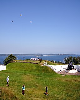
York Redoubt is a redoubt situated on a bluff overlooking the entrance to Halifax Harbour at Ferguson's Cove, Nova Scotia, Canada, originally constructed in 1793. It was designated a National Historic Site of Canada in 1962.
Purcell's Cove or Purcells Cove is a community within the Halifax Regional Municipality, Nova Scotia, Canada, on the west side of Halifax Harbour from the Northwest Arm to Fergusons Cove along Route 253.
Terence Bay is a rural fishing community on the Chebucto Peninsula in the Halifax Regional Municipality, Nova Scotia. It is located on the shore of the Atlantic Ocean, 10 km off the Prospect Road, off Route 333, 21.2 kilometers from Halifax.
Duncan's Cove is a small rural community on the Chebucto Peninsula in the Halifax Regional Municipality on the shore of the Atlantic Ocean on the Ketch Harbour Road, 19 kilometers from Halifax. The community is located beside Chebucto Head, the prominent coastal headland.
West Pennant is a rural community located at the head of Pennant Harbour near Sambro on the Chebucto Peninsula in the Halifax Regional Municipality Nova Scotia on Route 349 West Pennant is an old fishing community that sits on Fawson and Long Coves that open into Pennant Harbour. There are nearby islands: Martin Island, Powers Island, and Pennant Island. Powers Island is privately owned. Once Mi'k Maq hunting and fishing grounds, West Pennant has been occupied by three dominant colonial families since the mid 1700s: the Marriotts, Grays, and Toughs. Just 25 minutes from Halifax, West Pennant is evolving into a suburb of Halifax with many local residents moving in from other parts of Canada and overseas. Until the 1970s most families earned their living fishing, now most families have one or more members who work in Halifax-Dartmouth. West Pennant is also home to cottagers. The local corner store is Mishoo's Right Stop. West Pennant is only a few kilometres from Crystal Crescent Beach Provincial park, a unique beach flanked with granite outcrops and white sand beaches. West Pennant also borders Terrance Bay Wilderness area. Local wildlife include porcupines, deer, coyotes, bobcat, black bear, pheasant, partridge, bald eagles, golden eagles, herring gulls, osprey, beaver, moles, shrew, monarch butterfly (seasonal), raccoon, mink, muskrat, otter, harbour seals, blue jays, american goldfinch, american robin, hummingbirds (seasonal), bobcat, and possibly cougar, and right whale. Fishing is a common occupation and hobby. The dominant species caught in Pennant Harbour are Atlantic Cod, Mackerel, Boston Blue Fish, and further out, Halibut, Swordfish, and Haddock. Squid can be caught off of the government wharf in Sambro during summer nights. There is also a commercial fishery for lobster. Once the poor man's food, lobster is now a local delicacy.
Cowie Hill is a subdivision of Mainland Halifax in the Halifax Regional Municipality, Nova Scotia. The hill on which it is situated was originally called "Cowie's Hill", named after one of the original owners of the land, Robert Cowie. Cowie was a British merchant, who was granted the land in 1752 by Governor Edward Cornwallis. Over time, the apostrophe 's' in "Cowie's Hill" was dropped.
Ketch Harbour is a rural fishing and residential community on the Chebucto Peninsula in the Halifax Regional Municipality on the shore of the Atlantic Ocean on Route 349, 17 kilometers from Halifax. It is currently inhabited by people who, for the most part, commute to Halifax and its surrounding areas to work. The community attained ownership of the government wharf in 1999 and since that time have worked to maintain public access to the harbour for the community. Ketch Harbour established a residents association at the same time to ensure its long term sustainability.

The Chebucto Community Net (CCN) is a Canadian FreeNet operating in Nova Scotia's Halifax Regional Municipality (HRM). It is registered as a non-profit society under Nova Scotia's Registry of Joint Stocks using the name Chebucto Community Net Society. The name "Chebucto" comes from the local l'nu word for Halifax Harbour meaning "big water".
Chebucto Head is a Canadian headland on Nova Scotia's Chebucto Peninsula located within the community of Duncan's Cove.
Hackett's Cove is a rural community of the Halifax Regional Municipality in the Canadian province of Nova Scotia on the Chebucto Peninsula.
Herring Cove is a Canadian suburban and former fishing community in Nova Scotia's Halifax Regional Municipality. It is situated on the eastern shore of the Chebucto Peninsula, 15 km (9.3 mi) south of Downtown Halifax. It is near the western approaches to Halifax Harbour, and can be reached both via Purcell's Cove along the coastal road and from inland via the Herring Cove Road through Spryfield. There are two schools in Herring Cove, William King Elementary and Herring Cove Junior High. The community is also home to a small variety of small businesses and programs.
CIRP-FM is a non-profit radio station which broadcasts a Christian radio format from Spryfield, Nova Scotia, and serving the Halifax, Nova Scotia market. The station is owned by City Church of Halifax on Herring Cove Road. CIRP-FM plays Light Christian Contemporary music in the morning and Southern Gospel music later in the day.
Connaught Battery is a World War I era harbour defence battery located north of York Redoubt at Ferguson's Cove, Nova Scotia, Canada. It took its name from the then Governor General of Canada, the Duke of Connaught, who was Queen Victoria's third son.

