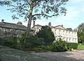
Field House, Sowerby

Last updated

Field House
Field House, Sowerby (4571526211).jpg
Field House, Sowerby
General information
TypePrivate Residence
Architectural stylePalladian
Town or city Sowerby Bridge
CountryEngland
Coordinates 53°42′01″N1°56′19″W / 53.7002°N 1.9385°W / 53.7002; -1.9385
Designations
Listed Building – Grade II*
Official nameField House, Sowerby
Designated15 November 1966
Reference no. 1313736
Listed Building – Grade II
Official nameField House Old Hall, Sowerby
Designated15 November 1966
Reference no. 1134527

Field House is a Grade II* listed privately owned historic house in Sowerby Bridge, West Yorkshire, England. [1] [2]

Contents

History

Field House (Old Hall) is mentioned as being in the possession of William Brig in 1533 and it passed to other owners during the 17th century but by the 1740s was owned by George Stansfeld (1725–1805) of Sowerby, a descendant of the Stansfeld family of Stansfield, Yorkshire. He built a new house (Field House) in 1749, and this estate later passed to his cousin Robert Stansfeld (1771–1855), then his son, Col. Robert Stansfeld (1805–85), to his second son, John Stansfeld (1840–1928) who married Eliza Arkley of Dunninald Castle, and then passed to a cousin, George Reginald Stansfeld (1870–1964). [3]

Architecture

Field House Old Hall

This Grade II listed house, dating from the early 17th century and with 19th century alterations, is now 2 dwellings. It has hollow-moulded double-chamfered mullion windows and a heavily-moulded Tudor-arched doorway amongst other features. [4]

Field House

This Grade II* listed house is in a Palladian style, with some 19th century additions and incorporating earlier elements (a 16th century Perpendicular style transomed 5-light pointed-arch window, and 2 columns supporting a cupola-style bellcote with tripled columns and finials) from St Peter's Church, Sowerby when it was rebuilt in 1762. [5]

Other listed aspects of the site include:

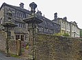
The Grade II listed Stables, which probably dates from the mid-18th century with mid-19th century additions and a reused seventeenth century 6-light double-chamfered mullion window. [6] [7]

The Grade II listed Workshop and Barn Range (incorporating 4 cottages) which probably dates from the mid 18th century but with late 16th and early 17th century features (such as reused hollow-moulded double-chamfered mullion windows) and 19th century alterations. [8] [9]

The Grade II listed Orangery (dating from 1749 but in character probably c.1874). [10] [11] Also, a 19th century Fountain, [12] [13] some pairs of mid-18th century Gate Piers, [14] [15] mid-19th century Gate Piers, [16] [17] and late 19th century Gate Piers (dated 1749 rebuilt 1874). [18] [19]

See also

Related Research Articles

<span class="mw-page-title-main">Ripponden</span> Village and civil parish in West Yorkshire, England

Ripponden is a village and civil parish on the River Ryburn near Halifax in West Yorkshire, England. Historically it was part of the West Riding of Yorkshire. Its population was 6,412 at the time of the 2001 Census, and 7,421 in 2011.

<span class="mw-page-title-main">Sowerby Bridge</span> Market town in West Yorkshire, England

Sowerby Bridge is a market town in the Upper Calder Valley in Calderdale in West Yorkshire, England. The Calderdale Council ward population at the 2011 census was 11,703.

<span class="mw-page-title-main">Lyme Park</span> Grade I listed building in Cheshire East, UK

Lyme Park is a large estate south of Disley, Cheshire, England, managed by the National Trust and consisting of a mansion house surrounded by formal gardens and a deer park in the Peak District National Park. The house is the largest in Cheshire, and is recorded in the National Heritage List for England as a designated Grade I listed building.

<span class="mw-page-title-main">Packhorse bridge</span> Type of bridge

A packhorse bridge is a bridge intended to carry packhorses across a river or stream. Typically a packhorse bridge consists of one or more narrow masonry arches, and has low parapets so as not to interfere with the panniers borne by the horses. Multi-arched examples sometimes have triangular cutwaters that are extended upward to form pedestrian refuges.

<span class="mw-page-title-main">Dunham Massey</span> English civil parish

Dunham Massey is a civil parish in the Metropolitan Borough of Trafford, Greater Manchester, England. The parish includes the villages of Sinderland Green, Dunham Woodhouses and Dunham Town, along with Dunham Massey Hall and Park, formerly the home of the last Earl of Stamford and owned by the National Trust since 1976. Dunham Massey is in the historic county of Cheshire, but since 1974 has been part of Trafford Metropolitan Borough; the nearest town is Altrincham. At the 2001 census, the parish had a population of 475.

<span class="mw-page-title-main">Sowerby, West Yorkshire</span> Village in West Yorkshire, England

Sowerby is a village in the Metropolitan Borough of Calderdale, in West Yorkshire, England. It lies in the Pennines, contiguous with Sowerby Bridge, 3.7 miles (6.0 km) west-southwest of Halifax.

<span class="mw-page-title-main">Tregarden</span>

Tregarden is a Grade II* listed large house built by the Barrett family in the late 16th century in the parish of St Mabyn, Cornwall, England.

<span class="mw-page-title-main">Dodington Park</span>

Dodington Park is a country house and estate in Dodington, South Gloucestershire, England. The house was built by James Wyatt for Christopher Bethell Codrington. The family had made their fortune from sugar plantations in the Caribbean and were significant owners of slaves. It remained in the Codrington family until 1980; it is now owned by the British businessman James Dyson.

<span class="mw-page-title-main">Barkisland</span> Village in West Yorkshire, England

Barkisland is a village in Calderdale, West Yorkshire, England. Historically part of the West Riding of Yorkshire, it is 1 mile (1.6 km) east of Ripponden, 2 miles (3.2 km) south of Sowerby Bridge and 4 miles (6.4 km) south-west of Halifax town centre.

<span class="mw-page-title-main">Bratton Court</span> Building in England

Bratton Court in the hamlet of Bratton within the parish of Minehead Without, Somerset, England was built as a manor house, with a 14th-century open hall and 15th-century solar hall. It is within the Exmoor National Park and has been designated as a Grade I listed building. It was enlarged in the 17th century and extensively altered in the late 19th and early 20th centuries. It is now a farmhouse divided into 2 dwellings. The gatehouse and the barn at the west end of the courtyard date from the fifteenth century and are also listed as Grade I buildings.

<span class="mw-page-title-main">Crowe Hall</span> Historic site

Crowe Hall is a Georgian house in Widcombe, Bath, Somerset, England. It is a Grade II listed building, and the gardens are on the Register of Historic Parks and Gardens of special historic interest in England.

<span class="mw-page-title-main">Frampton Court</span> English estate

Frampton Court is a Grade I listed country house and estate of about 1,500 acres (610 ha) in Frampton-on-Severn, Gloucestershire, England. It has been owned by the Clifford family since the 11th century. The main buildings are the 18th century Frampton Court and, on the opposite side of the village green, Manor Farm. The gardens at Frampton Court have a Gothic orangery and ornamental canal in the style of William Halfpenny. The two houses, barn and orangery are all Grade I listed buildings in their own right, while the Gatepiers and Gates are Grade II* listed.

Temple Sowerby is a civil parish in the Eden District, Cumbria, England. It contains 42 listed buildings that are recorded in the National Heritage List for England. Of these, one is listed at Grade I, the highest of the three grades, one is at Grade II*, the middle grade, and the others are at Grade II, the lowest grade. The parish contains the village of Temple Sowerby and the surrounding countryside. Most of the listed buildings are in the village, and consist of houses and associated structures, farmhouses and farm buildings. Also in the village and listed are a public house, a telephone kiosk and a maypole. Outside the village, and listed, are Acorn Bank House and a water mill, both with associated structures.

Ryburn is a ward to the southwest of Halifax in the metropolitan borough of Calderdale, West Yorkshire, England. It contains 84 listed buildings that are recorded in the National Heritage List for England. Of these, two are listed at Grade I, the highest of the three grades, three are at Grade II*, the middle grade, and the others are at Grade II, the lowest grade. The largest settlement in the ward is the village of Sowerby. There are some smaller settlements, including Mill Bank, but the rest of the ward is essentially rural. There is an industrial complex to the southeast of Sowerby around a former mill, Mill House Estate, and some of the buildings in this complex are listed. The River Ryburn runs through the ward, and a bridge crossing it is listed. Most of the listed buildings are houses and associated structures, cottages, farmhouses and farm buildings. The other listed buildings include churches, items in a churchyard, a public house, a milepost, former mills, a mill chimney, and a former chapel.

Sowerby Bridge is a market town and a ward to the southwest of Halifax in the metropolitan borough of Calderdale, West Yorkshire, England. It contains 67 listed buildings that are recorded in the National Heritage List for England. Of these, three are at Grade II*, the middle of the three grades, and the others are at Grade II, the lowest grade. The ward contains the town of Sowerby Bridge, the smaller settlement of Friendly, and the surrounding area. Industries developed in the area from the later 18th century following the building of the Calder and Hebble Navigation and the Rochdale Canal. Most of the industrial buildings have gone, but some mills remain that have been converted for other uses and are listed. In addition to the canals, the River Calder and the River Ryburn run through the area, and the listed buildings associated with these waterways are bridges, locks, warehouses, and other structures. The other listed buildings include houses and associated structures, road and railway bridges, shops, civic buildings, churches and associated structures, a former Sunday school, farmhouses and farm buildings, a milepost, a milestone, public houses and hotels, and a folly in the form of a tower.

Stansfield Hall is a privately owned historic and Grade II* listed building, in Stansfield, Todmorden, West Yorkshire, England, which was once the residence of the Yorkshire MP Joshua Fielden and is now divided into private residential apartments.

<span class="mw-page-title-main">Dunninald Castle</span> Privately owned castle in Angus, Scotland, UK

Dunninald Castle is a privately owned country house south of Montrose in Angus, Scotland, which was listed as Category A by Historic Scotland in 1971.

<span class="mw-page-title-main">Handle Hall</span> Grade II listed privately owned historic house in Calderbrook, Littleborough, Greater Manchester

Handle Hall is a Grade II listed privately owned historic house in Calderbrook, Littleborough, Greater Manchester.

<span class="mw-page-title-main">Stansfield, West Yorkshire</span> Human settlement in Todmorden, West Yorkshire, England

Stansfield is a place and township in the civil parish of Todmorden and Metropolitan Borough of Calderdale, in West Yorkshire, England, which gave its name to Stansfield Hall, Stansfield Hall Railway Station, and an electoral ward in Todmorden, Calderdale.

<span class="mw-page-title-main">Kebroyd</span> Human settlement in England

Kebroyd is a small hamlet in the civil parish of Ripponden, in the Calderdale district, in West Yorkshire, England, within the valley of the River Ryburn, between Sowerby Bridge and Ripponden. Kebroyd has an approximate population of 548 people as per the UK 2011 Census.

References

  1. Historic England. "Field House, Calderdale (1313736)". National Heritage List for England . Retrieved 2 April 2021.
  2. "Field House, Ryburn, Calderdale". britishlistedbuildings.co.uk. Retrieved 2 April 2021.
  3. Stansfeld, J. (1885). History of the Family of Stansfeld of Stansfield in the Parish of Halifax and its numerous branches. Leeds. pp. 213–17.{{cite book}}: CS1 maint: location missing publisher (link)
  4. "Field House old Hall, Ryburn, Calderdale". britishlistedbuildings.co.uk. Retrieved 2 April 2021.
  5. Kendall, H. P. (1902). "Antiquarians at Sowerby. A Pleasant Ramble". Transactions of the Halifax Antiquarian Society. 1.
  6. "Stable Range to North East of Field House, Ryburn, Calderdale". britishlistedbuildings.co.uk. Retrieved 2 April 2021.
  7. Historic England. "STABLE RANGE TO NORTH EAST OF FIELD HOUSE, Calderdale (1134528)". National Heritage List for England . Retrieved 2 April 2021.
  8. Historic England. "WORKSHOP AND BARN RANGE TO WEST AND NORTH OF FIELD HOUSE, Calderdale (1313737)". National Heritage List for England . Retrieved 2 April 2021.
  9. "Workshop and Barn Range to West and North of Field House, Ryburn, Calderdale". britishlistedbuildings.co.uk. Retrieved 2 April 2021.
  10. Historic England. "ORANGERY APPROXIMATELY 50 METRES TO NORTH OF WORKSHOP AND BARN RANGE AT FIELD HOUSE, Calderdale (1183971)". National Heritage List for England . Retrieved 2 April 2021.
  11. "Orangery Approximately 50 Metres to North of Workshop and Barn Range at Field House, Ryburn, Calderdale". britishlistedbuildings.co.uk. Retrieved 2 April 2021.
  12. "Fountain Approximately 25 Metres to North East of Field House, Ryburn, Calderdale". britishlistedbuildings.co.uk. Retrieved 2 April 2021.
  13. Historic England. "FOUNTAIN APPROXIMATELY 25 METRES TO NORTH EAST OF FIELD HOUSE, Calderdale (1183978)". National Heritage List for England . Retrieved 2 April 2021.
  14. "Gatepiers to South of Field House, Ryburn, Calderdale". britishlistedbuildings.co.uk. Retrieved 2 April 2021.
  15. Historic England. "GATEPIERS TO SOUTH OF FIELD HOUSE, Calderdale (1134462)". National Heritage List for England . Retrieved 2 April 2021.
  16. "Gate Piers to Back Yard at Field House, Ryburn, Calderdale". britishlistedbuildings.co.uk. Retrieved 2 April 2021.
  17. Historic England. "GATE PIERS TO BACK YARD AT FIELD HOUSE, Calderdale (1134529)". National Heritage List for England . Retrieved 2 April 2021.
  18. "Gate Piers with Gates Approximately 70 Metres to East of Field House, Ryburn, Calderdale". britishlistedbuildings.co.uk. Retrieved 2 April 2021.
  19. Historic England. "GATE PIERS WITH GATES APPROXIMATELY 70 METRES TO EAST OF FIELD HOUSE, Calderdale (1134526)". National Heritage List for England . Retrieved 2 April 2021.