
Wolverhampton Civic Hall is a music venue in Wolverhampton, West Midlands, England. It has been one of the most notable live music venues in the county for several decades. It is part of a complex branded as University of Wolverhampton at The Halls, Wolverhampton including University of Wolverhampton at The Civic Hall, University of Wolverhampton at Wulfrun Hall and the Slade Rooms. The complex is owned by City of Wolverhampton Council, operated by AEG Presents and is a Grade II listed building.

Oldbury is a market town in the metropolitan borough of Sandwell, in the county of the West Midlands, England. It is the administrative centre of the borough. At the 2011 census, the town had a population of 13,606, while the 2017 population of the wider built-up area was estimated at 25,488. Sandwell Metropolitan Borough Council, which defines Oldbury Town as consisting of the wards of Bristnall, Langley, Oldbury, and Old Warley, gave the population as 50,641 in 2011.
Compton is a suburb of Wolverhampton, West Midlands, England. It is located to the west of Wolverhampton city centre on the A454, within the Tettenhall Wightwick ward.

Tettenhall is a historic village within the City of Wolverhampton, in the county of the West Midlands, England. Tettenhall became part of Wolverhampton district in 1966, along with Bilston, Wednesfield and parts of Willenhall, Coseley and Sedgley.
Oxley is a suburb of Wolverhampton, West Midlands, and a ward of the City of Wolverhampton Council. Its area code is WV10. It is situated in the north of the city, bordering South Staffordshire and the Bushbury North, Bushbury South and Low Hill, St Peter's and Tettenhall Regis wards. It forms part of the Wolverhampton West constituency.

Bushbury is a suburban village and ward in the City of Wolverhampton in the West Midlands, England. It lies two miles north-east of Wolverhampton city centre, divided between the Bushbury North and Bushbury South and Low Hill wards. Bushbury also lies near to the villages of Coven, Featherstone and Four Ashes which are in South Staffordshire.

Whitmore Reans is in Wolverhampton, West Midlands, England. It is situated to the north-west of the city centre, in the city council's Park and St Peter's wards.

Merry Hill is a suburb of Wolverhampton, West Midlands and a ward of Wolverhampton City Council. It is situated in the south-west of the city, bordering South Staffordshire and the Tettenhall Wightwick, Park, Graiseley and Penn wards. It forms part of the Wolverhampton West constituency.
Castlecroft is a suburb of Wolverhampton, West Midlands, located on the edge of the city, WSW of the city centre. It is situated where the Merry Hill, and Tettenhall Wightwick wards meet, and also borders South Staffordshire.
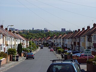
Park, or Park Ward, is a ward of Wolverhampton City Council, West Midlands. It is located to the west of the city centre, and covers parts of the suburbs Bradmore, Compton, Finchfield, Merridale, Newbridge and Whitmore Reans. It borders the St Peter's, Graiseley, Merry Hill, Tettenhall Wightwick and Tettenhall Regis wards. It forms part of the Wolverhampton West constituency.
Tettenhall Wightwick is a ward of Wolverhampton City Council, West Midlands. The population of this ward taken at the 2011 census was 10,872.
Aldersley is a suburb of Wolverhampton, West Midlands, England. It is north-west of Wolverhampton city centre, within the Tettenhall Regis ward. Aldersley is a relatively modern part of Wolverhampton, with most of the housing stock – both private and council – dating from after World War II.
Claregate is a suburb of Wolverhampton, West Midlands, England. It is north west of Wolverhampton city centre, within the Tettenhall Regis ward.
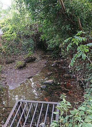
Tettenhall Wood is a suburb of Wolverhampton, West Midlands, England. It is west of Wolverhampton city centre, within the Tettenhall Wightwick ward. It sits high on a relatively steep hill and it is claimed that the Malvern Hills can be seen from some of the houses located in the area. To its west lies Wightwick, to its south Compton to its east Tettenhall. Also to its north lies the boundary of the West Midlands conurbation and also that of Wolverhampton metropolitan authority with South Staffordshire. The River Penk rises in the area, at Penk Rise Park.
The Express & Star is a regional evening newspaper in Britain. Founded in 1889, it is based in Wolverhampton, England, and covers the West Midlands county and Staffordshire.

Wolverhampton is a city and metropolitan borough in the West Midlands, England, 13 miles (21 km) northwest of Birmingham. The population in 2021 was 263,700.
Bentley Bridge Leisure Park is an extensive modern leisure/retail park located in the village of Wednesfield,Wolverhampton in the West Midlands. It has been developed since the late 1990s, to the south of Wednesfield town centre.
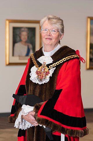
Claire Darke is a British politician who served as Mayor of Wolverhampton from 2019 to 2021, holding the distinction of being the longest continuously serving female mayor in the city's history. First elected the councillor for Park Ward in 2008 as a Liberal Democrat before switching to the Labour Party in 2011, she currently serves as an Independent, having resigned from the Labour Party in 2024.


