
Escambia County is the westernmost and oldest county in the U.S. state of Florida. It is in the state's northwestern corner. At the 2020 census, the population was 321,905. Its county seat and largest city is Pensacola. Escambia County is included within the Pensacola-Ferry Pass-Brent, Florida, Metropolitan Statistical Area. The county population has continued to increase as the suburbs of Pensacola have developed.

Santa Rosa County is a county located in the northwestern portion of the U.S. state of Florida. As of 2020, the population is 184,313. The county seat is Milton, which lies in the geographic center of the county. Other major communities within Santa Rosa County are Navarre, Pace, and Gulf Breeze. Navarre is the most populated community with a population of approximately 45,000 residents. Santa Rosa County is included in the Pensacola Metropolitan Statistical Area, which also includes Escambia County.
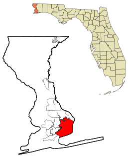
Pensacola is the westernmost city in the Florida Panhandle, and the county seat and only incorporated city of Escambia County, Florida, United States. As of the 2020 United States census, the population was 54,312. Pensacola is the principal city of the Pensacola Metropolitan Area, which had an estimated 502,629 residents as of 2019.

The Florida Panhandle is the northwestern part of the U.S. state of Florida; it is a strip of land roughly 200 miles (320 km) long and 50 to 100 miles wide, lying between Alabama on the north and the west, Georgia on the north, and the Gulf of Mexico to the south. Its eastern boundary is arbitrarily defined. In terms of population, major communities include Tallahassee, Pensacola, and Navarre.

Navarre is a census-designated place and unincorporated community in Santa Rosa County in the northwest Florida Panhandle. It is a major bedroom community for mostly U.S. military personnel, federal civil servants, local population, retirees and defense contractors. Due to Navarre Beach and the 4 miles (6.4 km) of beach front on the Gulf of Mexico thereof, as well as several miles of beaches within the Navarre Beach Marine Park and the Gulf Islands National Seashore, it has a small, but rapidly growing community of nature enthusiasts and tourists. Navarre has grown from being a small town of around 1,500 in 1970 to a town with a population estimated at 41,940 as of 2020, if including both the Navarre and Navarre Beach Census Designated Places.

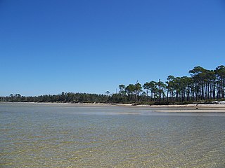
Gulf Islands National Seashore offers recreation opportunities and preserves natural and historic resources along the Gulf of Mexico barrier islands of Florida and Mississippi. The protected regions include mainland areas and parts of seven islands. Some islands along the Alabama coast were originally considered for inclusion, but none are part of the National Seashore.
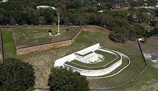
Fort Barrancas (1839) or Fort San Carlos de Barrancas is a United States military fort and National Historic Landmark in the former Warrington area of Pensacola, Florida, located physically within Naval Air Station Pensacola, which was developed later around it.
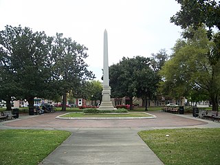
The Plaza Ferdinand VII is an outdoor garden and park in the Historic Pensacola Village area of downtown Pensacola, Florida. It is located on Palafox Street between Government and Zaragoza Streets. It was named after Ferdinand VII of Spain, the King of Spain between 1813 and 1833. A National Historic Landmark, it is the site of the formal transfer of Florida to United States jurisdiction in 1821.
The Fairpoint Peninsula is located in northwest Florida between Santa Rosa Sound and Pensacola Bay.

The Newnansville Town Site was where the former town of Newnansville, Florida was located. Originally within Alachua County, in 1832 it became part of the newly formed Columbia County, but in 1839 it was restored as the county seat of Alachua. When it was realized that the Florida Railroad would bypass Newnansville, the county voted in 1854 to move the county seat to Gainesville, a newly founded railroad town. Bypassed again by another railroad in the late 1880s, Newnansville could not survive the competition. It was abandoned in the 20th century.
Oriole Beach is an unincorporated community located in Santa Rosa County, Florida, United States on Santa Rosa Sound. It lies east of Gulf Breeze on the Fairpoint Peninsula, and about three miles north of Pensacola Beach. Oriole Beach is part of the Pensacola–Ferry Pass–Brent Metropolitan Statistical Area.

The Pensacola metropolitan area is the metropolitan area centered on Pensacola, Florida. It is also known as the Pensacola-Ferry Pass-Brent Metropolitan Statistical Area, a metropolitan statistical area (MSA) used for statistical purposes by the United States Census Bureau and other agencies. The Pensacola Standard Metropolitan Statistical Area was first defined after the 1960 United States Census, with Pensacola as the principal city, and included Escambia and Santa Rosa counties. Ferry Pass and Brent, which are unincorporated census-designated places in Escambia County, were added as principal cities after the 2000 Census. The population of the MSA in the 2020 census was 511,502.
The Naval Live Oaks Reservation is part of the Gulf Islands National Seashore, and is near Gulf Breeze, Florida. It was purchased by U.S. government in 1828 as the first federal tree farm and began operations January 18, 1829. It serves today as part of the Gulf Islands National Seashore forest community preserved by the National Park Service on January 8, 1971, and added to the U.S. National Register of Historic Places on September 28, 1998.

The Lloyd Railroad Depot is a historic depot building in Lloyd, Florida in the United States. Built in 1858 by the Pensacola and Georgia Railroad, it is the oldest brick railroad station in Florida and one of only three surviving railroad depots in the state built prior to the start of the American Civil War. The building closed in 1966 after its owner at the time, the Seaboard Air Line Railroad, discontinued service there and donated it to the Jefferson County Historical Society. A few years later, ownership was transferred to the Gulf Wind Chapter of the National Railway Historical Society, who own it to this day. On December 2, 1974, it was added to the U.S. National Register of Historic Places. The structure is located near the junction of SR 59 and Lester Lawrence Road. It is currently used as a post office.
The Third Gulf Breeze, (8SR8), is a Santa Rosa-Swift Creek culture archaeological site near Gulf Breeze, Florida. On September 28, 1998, it was added to the U.S. National Register of Historic Places.
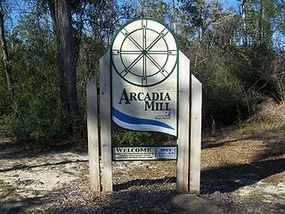
The Arcadia Sawmill and Arcadia Cotton Mill is a historic site a mile southwest of Milton, Florida, United States. On August 3, 1987, it was added to the U.S. National Register of Historic Places.
The Naval Live Oaks Cemetery is a prehistoric cemetery associated with the Pensacola culture, a regional variant of the Mississippian culture. It is located near Gulf Breeze, Florida. On September 28, 1998, it was added to the U.S. National Register of Historic Places.
The history of Pensacola, Florida, begins long before the Spanish claimed founding of the modern city in 1698. The area around present-day Pensacola was inhabited by Native American peoples thousands of years before the historical era.

The following is an alphabetical list of articles related to the U.S. state of Florida.

The Bellamy Road was the first major U.S. federal highway in early territorial Florida.


