Fair Haven is a village located on the southern shore of Lake Ontario in Cayuga County, New York, United States. As of the 2020 census, its population was 760. Fair Haven is within the town of Sterling and is northwest of Syracuse. The village is on Little Sodus Bay, an arm of Lake Ontario.

Little Falls is a city in Herkimer County, New York, United States. The population was 4,946 at the time of the 2010 census, which is the second-smallest city population in the state, ahead of only the city of Sherrill. The city is built on both sides of the Mohawk River, at a point at which rapids had impeded travel upriver. Transportation through the valley was improved by construction of the Erie Canal, completed in 1825 and connecting the Great Lakes with the Hudson River.
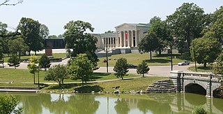
Delaware Park–Front Park System is a historic park system and national historic district in the northern and western sections of Buffalo in Erie County, New York. The park system was designed by Frederick Law Olmsted and Calvert Vaux and developed between 1868 and 1876.
Purcell & Elmslie (P&E) was the most widely know iteration of a progressive American architectural practice. P&E was the second most commissioned firm of the Prairie School, after Frank Lloyd Wright. The firm in all iterations was active from 1907 to 1921, with their most famous work being done between 1913 and 1921.

48 Wall Street, formerly the Bank of New York & Trust Company Building, is a 32-story, 512-foot-tall (156 m) skyscraper on the corner of Wall Street and William Street in the Financial District of Lower Manhattan in New York City. Built in 1927–1929 in the Neo-Georgian and Colonial Revival styles, it was designed by Benjamin Wistar Morris.

The Chamber of Commerce Building is a commercial building on 65 Liberty Street, between Liberty Place and Broadway, in the Financial District of Manhattan in New York City. Designed by architect James Barnes Baker, the four-story Beaux-Arts building was constructed between 1901 and 1902 as the first headquarters to be built specifically for the Chamber of Commerce of the State of New York.

Newtown Battlefield State Park, formerly known as Newtown Battlefield Reservation, was the site of the Battle of Newtown fought in August 1779, during the American Revolutionary War. It was the only major battle of the Sullivan Expedition, an armed offensive led by General John Sullivan that was ordered by the Continental Congress to end the threat of the Iroquois who had sided with the British in the American Revolutionary War. In the battle, the Iroquois were defeated decisively. A portion of the battlefield is today managed as a 372-acre (1.51 km2) state park. The entire battlefield was declared a National Historic Landmark in 1965. The American Battlefield Trust and its partners have acquired and preserved more than 68 acres adjacent to the state park.

Edna G is a tugboat which worked the Great Lakes and is now preserved as a museum ship. Edna G was built by the Cleveland Shipbuilding Company in 1896 for the Duluth and Iron Range Railroad at a cost $35,397.50. She was named for the daughter of J. L. Greatsinger, president of the railroad.

The Edna E. Lockwood is a Chesapeake Bay bugeye, the last working oyster boat of her kind. She is located at the Chesapeake Bay Maritime Museum in Saint Michaels, Maryland. She was built in 1889 at Tilghman Island, Maryland by John B. Harrison and is of nine-log construction, similar to the smaller log canoe, and was launched on October 5, 1889 for Daniel Haddaway, at a cost of $2,200. She worked for at least seven sets of owners from 1899 until 1967, and was then sailed as a yacht until donated to the museum in 1973. The museum undertook an extensive restoration of the Lockwood from 1975 through 1979, which restored the bugeye to its 1910 appearance with the "patent stern" that had been added sometime prior to that year. She is the last bugeye retaining the sailing rig and working appearance of the type. Her length is 53.5 feet (16.3 m), with a 15.25 feet (4.65 m) beam and a draft of 2.58 feet (0.79 m) with the centerboard up, and a maximum sail area of approximately 1700 square feet.

49 Chambers, formerly known as the Emigrant Industrial Savings Bank Building and 51 Chambers Street, is a residential building at 49–51 Chambers Street in the Civic Center neighborhood of Manhattan in New York City. It was built between 1909 and 1912 and was designed by Raymond F. Almirall in the Beaux-Arts style. The building occupies a slightly irregular lot bounded by Chambers Street to the south, Elk Street to the east, and Reade Street to the north.

The current Graham County Courthouse is a courthouse located at 800 W. Main St. in Safford, Arizona that is listed on the National Register of Historic Places. It is a two-story red brick building above a concrete foundation that includes a raised basement. The main part of the east-facing building is 83 feet (25 m) by 62 feet (19 m), and there is a one-story 17 feet (5.2 m) by 49 feet (15 m) north wing made of brick, and a small ell in the back.

The Raphael Semmes House, also known as the Horta–Semmes House, is a historic residence in Mobile, Alabama. It is best known for having been the home of Admiral Raphael Semmes, captain of the Confederate sloop-of-war CSS Alabama. The house was added to the National Register of Historic Places on February 26, 1970.
The Pioneer State Bank No. 36 is a bank building located at 4046 Huron Street (M-90) in the village of North Branch in North Branch Township in northern Lapeer County, Michigan. The bank stands as the oldest bank institution in North Branch. It was designated as a Michigan State Historic Site on October 23, 1979 and later added to the National Register of Historic Places on April 22, 1982.

The Beckley Furnace Industrial Monument is a state-owned historic site preserving a 19th-century iron-making blast furnace on the north bank of the Blackberry River in the town of North Canaan, Connecticut. The site became a 12-acre (4.9 ha) state park in 1946; it was added to the National Register of Historic Places in 1978.

The Waterman Covered Bridge was an historic covered bridge in Johnson, Vermont that carried Waterman Road across Waterman Creek. Built in 1868, it was one of three surviving 19th-century bridges in the town. It was listed on the National Register of Historic Places in 1974, and collapsed in January 1982.
Scott Covered Bridge is a covered bridge spanning the West River in Townshend, Vermont. Built in 1870, it is at 277 feet (84 m) one of the longest covered bridges in the state, exhibiting three different forms of support: a Town lattice truss, kingpost trusses, and laminated arches. The bridge was listed on the National Register of Historic Places in 1973. It is closed to all traffic.

The Iron Bridge at Howard Hill Road is a modern pony truss bridge, carrying Howard Hill Road across the Black River in southeastern Cavendish, Vermont. It is a replacement for an historic 1890 Pratt through truss bridge, which is now in storage. The historic bridge was listed on the National Register of Historic Places in 1982.

The Flynn–Griffin Building, also known as the Flynn Block, Peoples' Savings Bank Building, and the Edna M. Griffin Building, is a historic building located in Des Moines, Iowa, United States. It was listed on the National Register of Historic Places in 2016.

Poydras Street is a street that serves as the main artery of the New Orleans Central Business District, in New Orleans, Louisiana. The street is named for Julien de Lallande Poydras. Many of the city of New Orleans' and the state of Louisiana's tallest buildings have been built on the street since it was widened in the mid 1960s. The street also hosts several historic structures and is the boundary between two United States National Register of Historic Places districts.

